
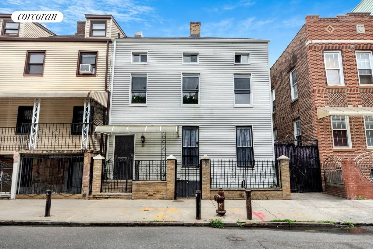
29 Cedar St
Brooklyn, NY 11221
-
Bedrooms
2
-
Bathrooms
1
-
Square Feet
--
-
Available
Available Now
Highlight
- Controlled Access

About This Home
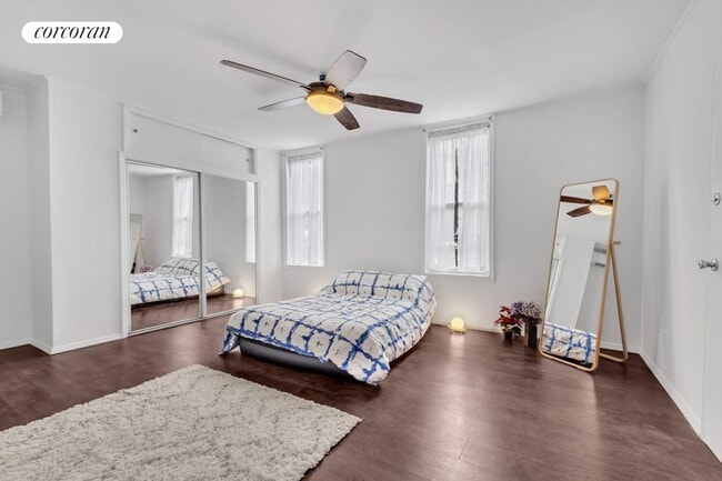
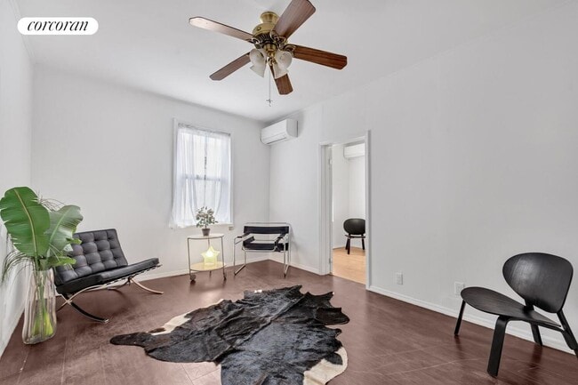
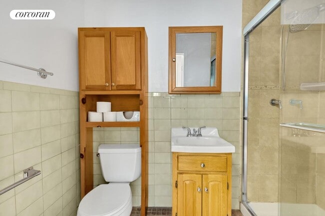
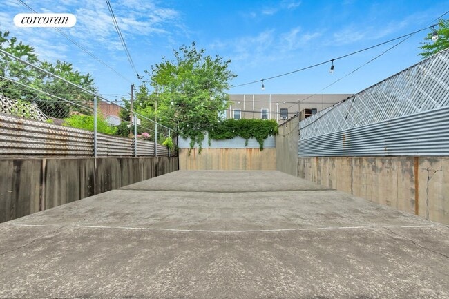
Two-bedroom apartment with a 1300 SF private back yard, located three blocks from Myrtle & Broadway. Available early August. Pets are case by case but generally welcome.29 Cedar St Apt 1 is a garden level 2 bedroom, 1 bath, approx 750 SF interior and 1300 SF exterior. Unit features HVAC mini-splits, and a washer-dryer laundry center. The layout is somewhat flexible and features windows facing predominantly northwest and southeast. But with such a big outdoor space why stay inside? Invite some friends over for a BBQ and cornhole! (...grill and cornhole not included)Located 1 block east of Bushwick Ave and less than 2 blocks south of Myrtle, 29 Cedar St is a short walk to the JMZ lines (Myrtle Ave / Central Ave / & Kosciuszko stations). A long list of local eateries and hang out spots abound including Wonderville, Nene's Deli Taqueria, Zatar's, BK Bagels, and Mad Tropical to name just a few.NOTES: Pets case by case. Two pet limitNo smoking inside the buildingAvailable early August, 12 month minimumAll square footage is approximate (see floor plan)Some photos may be virtually staged or retouchedNo fees except the credit reportGuarantors and shares are okayFirst month's rent, one month deposit due at lease signingUtilities are not included
29 Cedar St is an apartment community located in Kings County and the 11221 ZIP Code.
Features
- Air Conditioning
- Package Service
- Laundry Facilities
- Controlled Access
Fees and Policies
The fees below are based on community-supplied data and may exclude additional fees and utilities.
- Dogs Allowed
-
Fees not specified
-
Weight limit--
-
Pet Limit--
Details
Lease Options
-
12 Months
Contact
- Website View Property Website
- Contact
-
Source
- Air Conditioning
- Package Service
- Laundry Facilities
- Controlled Access
Neighboring Williamsburg to the east, Bushwick is a vibrant Brooklyn neighborhood known for its incredible street art, local shops, and diverse cuisine. Bushwick has historically served as a haven for immigrants, and now attracts scores of creative types to its many galleries and converted loft spaces.
In addition to a host of new local businesses, Bushwick offers residents exciting nightlife options and easy subway access. Colorful apartment buildings line quiet residential streets in Bushwick as well, providing plenty of rental opportunities to the community. Numerous neighborhood parks offer a tranquil reprieve from the big-city bustle.
Learn more about living in Bushwick| Colleges & Universities | Distance | ||
|---|---|---|---|
| Colleges & Universities | Distance | ||
| Drive: | 7 min | 2.2 mi | |
| Drive: | 8 min | 2.4 mi | |
| Drive: | 9 min | 3.1 mi | |
| Drive: | 12 min | 3.6 mi |
Transportation options available in Brooklyn include Central Avenue, located 0.2 mile from 29 Cedar St. 29 Cedar St is near LaGuardia, located 8.4 miles or 17 minutes away, and John F Kennedy International, located 11.6 miles or 20 minutes away.
| Transit / Subway | Distance | ||
|---|---|---|---|
| Transit / Subway | Distance | ||
|
|
Walk: | 3 min | 0.2 mi |
|
|
Walk: | 6 min | 0.3 mi |
|
|
Walk: | 7 min | 0.4 mi |
|
|
Walk: | 10 min | 0.5 mi |
|
|
Walk: | 14 min | 0.8 mi |
| Commuter Rail | Distance | ||
|---|---|---|---|
| Commuter Rail | Distance | ||
|
|
Drive: | 6 min | 2.5 mi |
|
|
Drive: | 8 min | 2.6 mi |
|
|
Drive: | 10 min | 3.6 mi |
|
|
Drive: | 12 min | 4.1 mi |
|
|
Drive: | 12 min | 4.3 mi |
| Airports | Distance | ||
|---|---|---|---|
| Airports | Distance | ||
|
LaGuardia
|
Drive: | 17 min | 8.4 mi |
|
John F Kennedy International
|
Drive: | 20 min | 11.6 mi |
Time and distance from 29 Cedar St.
| Shopping Centers | Distance | ||
|---|---|---|---|
| Shopping Centers | Distance | ||
| Drive: | 3 min | 1.3 mi | |
| Drive: | 6 min | 2.0 mi | |
| Drive: | 7 min | 2.7 mi |
| Parks and Recreation | Distance | ||
|---|---|---|---|
| Parks and Recreation | Distance | ||
|
Maria Hernandez Park
|
Walk: | 11 min | 0.6 mi |
|
Martinez Playground
|
Drive: | 4 min | 1.5 mi |
|
Sternberg Park
|
Drive: | 4 min | 1.6 mi |
|
Hattie Carthan Garden
|
Drive: | 6 min | 1.8 mi |
|
St. John's Park
|
Drive: | 7 min | 1.9 mi |
| Hospitals | Distance | ||
|---|---|---|---|
| Hospitals | Distance | ||
| Walk: | 15 min | 0.8 mi | |
| Walk: | 16 min | 0.8 mi | |
| Drive: | 7 min | 2.0 mi |
| Military Bases | Distance | ||
|---|---|---|---|
| Military Bases | Distance | ||
| Drive: | 19 min | 7.2 mi | |
| Drive: | 29 min | 11.5 mi |
You May Also Like
What Are Walk Score®, Transit Score®, and Bike Score® Ratings?
Walk Score® measures the walkability of any address. Transit Score® measures access to public transit. Bike Score® measures the bikeability of any address.
What is a Sound Score Rating?
A Sound Score Rating aggregates noise caused by vehicle traffic, airplane traffic and local sources
29 Cedar St
Brooklyn, NY 11221