
$2,400
/ Month
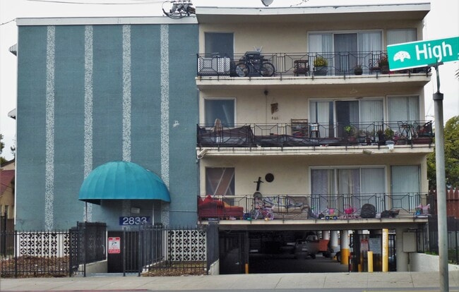
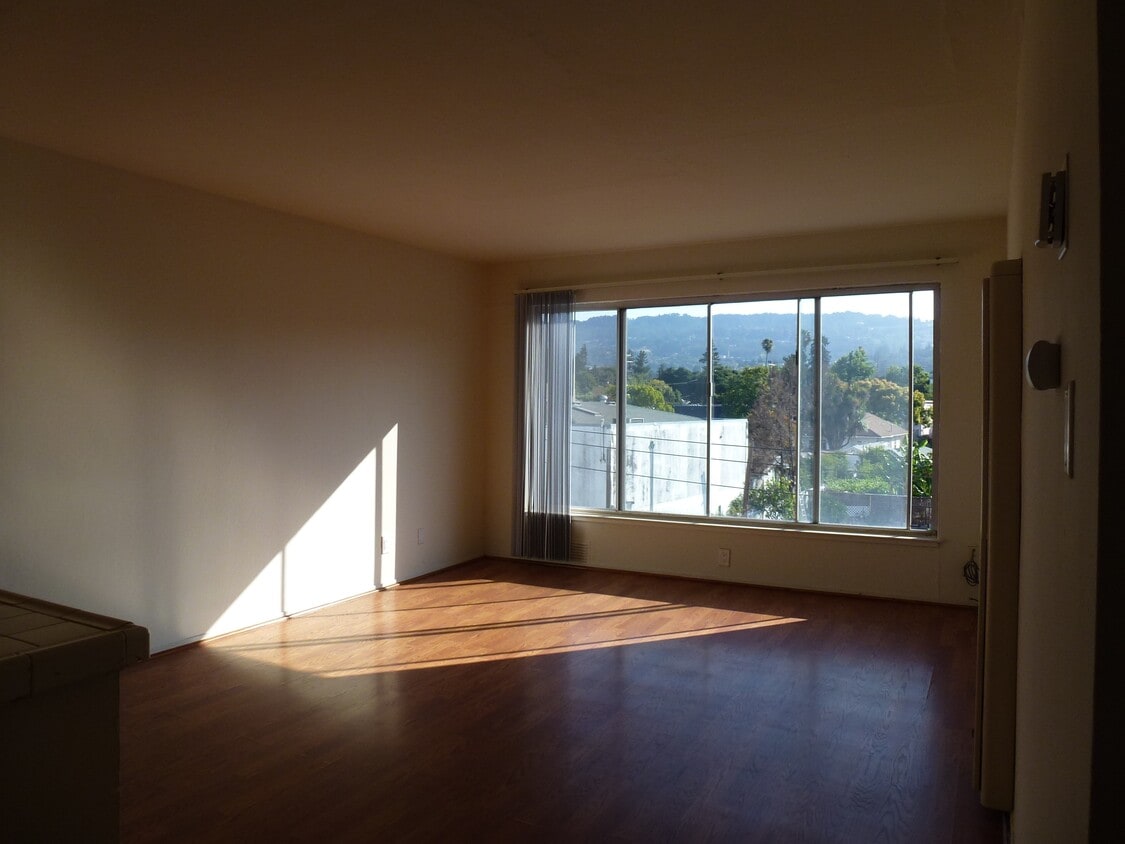
2833 High St Unit 312
Oakland, CA 94619
2 Weeks Ago
|
Edit
Favorites
2833 High St Unit 312

Favorites
Check Back Soon for Upcoming Availability
| Beds | Baths | Average SF |
|---|---|---|
| 2 Bedrooms 2 Bedrooms 2 Br | 1 Bath 1 Bath 1 Ba | 750 SF |
Fees and Policies
The fees below are based on community-supplied data and may exclude additional fees and utilities.
- Parking
-
Other$120/mo
Details
Utilities Included
-
Gas
-
Water
-
Heat
-
Trash Removal
-
Sewer
Property Information
-
39 units
About This Property
Gated Security Building Gated tuck under parking Security Cameras Elevator Located off the 580 Freeway and just below the popular Laurel District with restaurants, services, laundromats and amenities. Located on upper High St, and walking distance to Walgreens, other shopping opportunities and restaurants. Located just 15 minutes from San Francisco and 5 minutes from Alameda, Lake Merritt, Jack London Square and the Oakland International Airport.
2833 High St is an apartment community located in Alameda County and the 94619 ZIP Code.
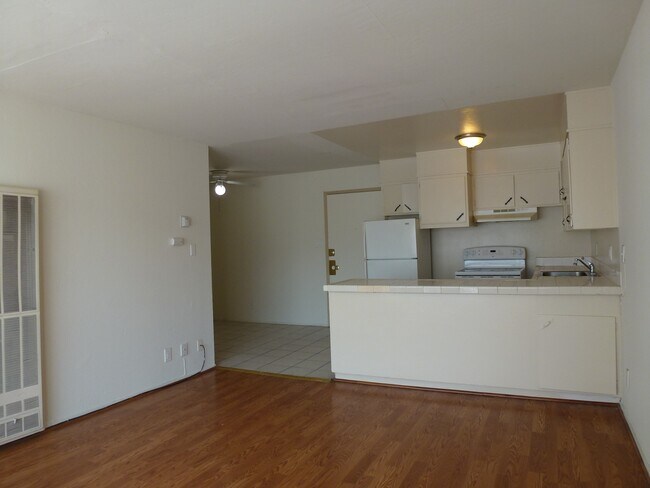
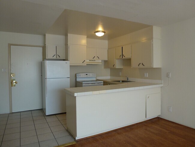
Apartment Features
Hardwood Floors
Refrigerator
Tile Floors
Security System
- Heating
- Smoke Free
- Cable Ready
- Security System
- Eat-in Kitchen
- Kitchen
- Refrigerator
- Hardwood Floors
- Tile Floors
- Views
- Elevator
- Gated
Location
Get Directions
Allendale is a mostly residential community just off the MacArthur Freeway. Residents enjoy a walkable landscape with a wide array of local amenities: Allendale Elementary School’s location in the north-central portion of the neighborhood gives students the option to walk to class safely; small grocers, cafes, and specialty businesses in the neighborhood keep folks well-fed and well-supplied; and Allendale Recreation Center provides a terrific venue for enjoying the sunshine with friends and neighbors.
A more diverse selection restaurants and shops can be found along MacArthur Boulevard just a few blocks to the northeast, and many more public parks surround Allendale on all sides. Numerous healthcare facilities in and around the neighborhood make it a great spot for medical professionals. Mills College is only a few blocks to the east, and of course the close proximity to the freeway makes it easy to reach anywhere in the Bay Area and beyond.
Learn more about living in AllendaleBelow are rent ranges for similar nearby apartments
Amenities
- Heating
- Smoke Free
- Cable Ready
- Security System
- Eat-in Kitchen
- Kitchen
- Refrigerator
- Hardwood Floors
- Tile Floors
- Views
- Elevator
- Gated
Expenses
Recurring
Unassigned Other Parking
$120
Utilities Included
Gas, Water, Heat, Trash Removal, Sewer
Included
Education
| Colleges & Universities | Distance | ||
|---|---|---|---|
| Colleges & Universities | Distance | ||
| Drive: | 5 min | 1.5 mi | |
| Drive: | 7 min | 4.2 mi | |
| Drive: | 9 min | 5.6 mi | |
| Drive: | 12 min | 6.8 mi |
2833 High St Unit 312 is within 5 minutes or 1.5 miles from Mills College. It is also near Laney College and Lincoln University, Oakland.
Transportation options available in Oakland include Fruitvale Station, located 1.7 miles from 2833 High St Unit 312. 2833 High St Unit 312 is near Metro Oakland International, located 6.6 miles or 11 minutes away, and San Francisco International, located 27.0 miles or 39 minutes away.
| Transit / Subway | Distance | ||
|---|---|---|---|
| Transit / Subway | Distance | ||
|
|
Drive: | 3 min | 1.7 mi |
|
|
Drive: | 5 min | 2.9 mi |
|
|
Drive: | 8 min | 4.9 mi |
|
|
Drive: | 8 min | 5.5 mi |
|
|
Drive: | 8 min | 5.5 mi |
| Commuter Rail | Distance | ||
|---|---|---|---|
| Commuter Rail | Distance | ||
|
|
Drive: | 8 min | 4.9 mi |
|
|
Drive: | 11 min | 8.0 mi |
|
|
Drive: | 14 min | 10.1 mi |
|
|
Drive: | 17 min | 11.8 mi |
| Drive: | 17 min | 11.8 mi |
| Airports | Distance | ||
|---|---|---|---|
| Airports | Distance | ||
|
Metro Oakland International
|
Drive: | 11 min | 6.6 mi |
|
San Francisco International
|
Drive: | 39 min | 27.0 mi |
Time and distance from 2833 High St Unit 312.
| Shopping Centers | Distance | ||
|---|---|---|---|
| Shopping Centers | Distance | ||
| Walk: | 16 min | 0.9 mi | |
| Walk: | 20 min | 1.0 mi | |
| Drive: | 3 min | 2.1 mi |
2833 High St Unit 312 has 3 shopping centers within 2.1 miles, which is about a 3-minute walk. The miles and minutes will be for the farthest away property.
| Parks and Recreation | Distance | ||
|---|---|---|---|
| Parks and Recreation | Distance | ||
|
Roberts Regional Recreation Area
|
Drive: | 9 min | 4.2 mi |
|
Redwood Regional Park
|
Drive: | 9 min | 4.4 mi |
|
Chabot Space & Science Center
|
Drive: | 12 min | 4.8 mi |
|
Joaquin Miller Park
|
Drive: | 12 min | 5.0 mi |
|
Martin Luther King Jr. Regional Shoreline
|
Drive: | 10 min | 5.6 mi |
2833 High St Unit 312 has 5 parks within 5.6 miles, including Joaquin Miller Park, Roberts Regional Recreation Area, and Martin Luther King Jr. Regional Shoreline.
| Hospitals | Distance | ||
|---|---|---|---|
| Hospitals | Distance | ||
| Drive: | 4 min | 2.3 mi | |
| Drive: | 4 min | 2.8 mi | |
| Drive: | 9 min | 3.7 mi |
2833 High St Unit 312 has 3 hospitals within 3.7 miles, the nearest is Telecare Heritage Psychiatric Health Facility which is 2.3 miles away and a 4 minute drive.
| Military Bases | Distance | ||
|---|---|---|---|
| Military Bases | Distance | ||
| Drive: | 16 min | 8.3 mi | |
| Drive: | 16 min | 8.5 mi |
2833 High St Unit 312 is 8.3 miles from Alameda/US Naval Air Station Alameda, and is convenient to other military bases, including Oakland Army Base.
You May Also Like
Similar Rentals Nearby


What Are Walk Score®, Transit Score®, and Bike Score® Ratings?
Walk Score® measures the walkability of any address. Transit Score® measures access to public transit. Bike Score® measures the bikeability of any address.
What is a Sound Score Rating?
A Sound Score Rating aggregates noise caused by vehicle traffic, airplane traffic and local sources
2833 High St
Oakland, CA 94619