$2,450
/ Month
283 Malcolm X Blvd
Brooklyn, NY 11233
2 Weeks Ago
|
Edit
Favorites
283 Malcolm X Blvd

Favorites
Check Back Soon for Upcoming Availability
| Beds | Baths | Average SF |
|---|---|---|
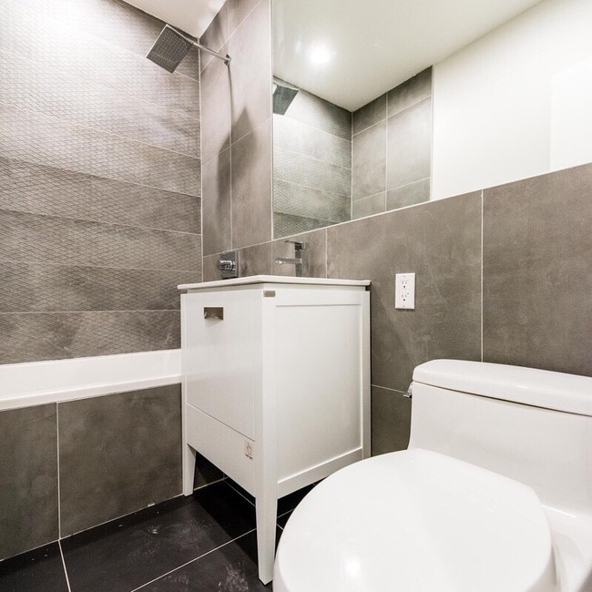
| 3 Bedrooms 3 Bedrooms 3 Br | 1 Bath 1 Bath 1 Ba | 950 SF |
About This Property
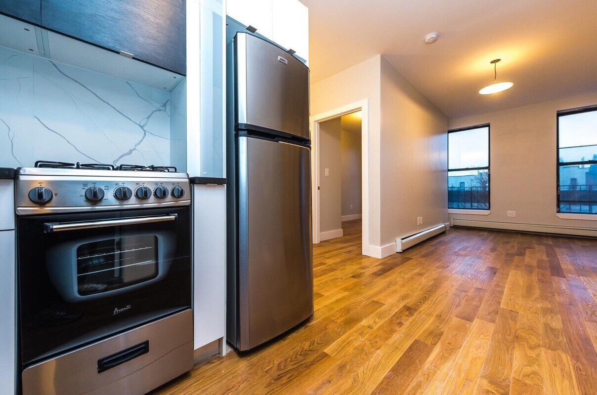
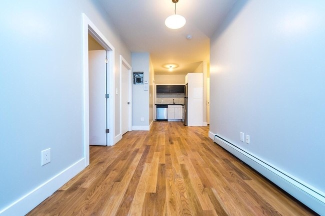
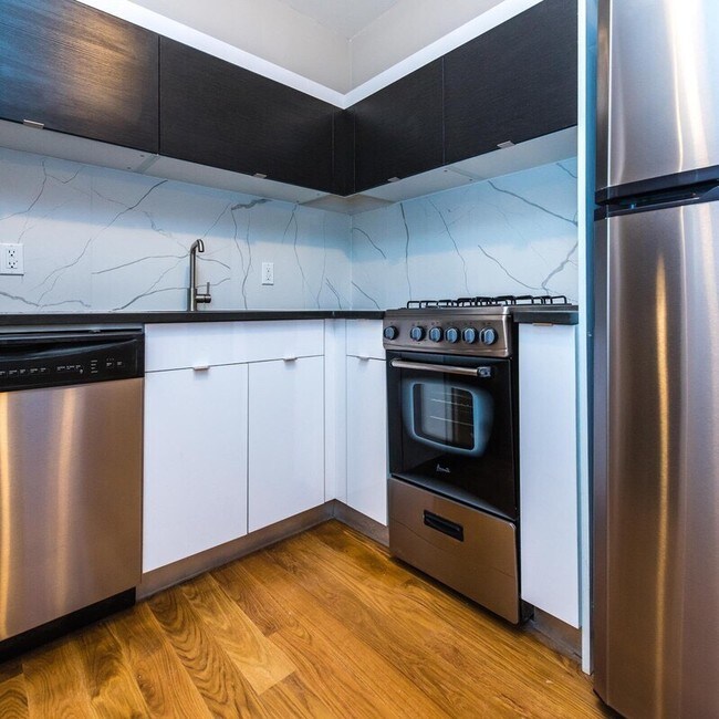
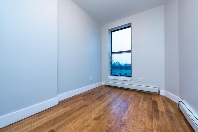
Located on a picturesque block lined with trees and beautiful brownstones. Drenched in light the apartment showcases high beamed ceilings, strip hardwood floors, and a kitchen that features stainless steel appliances including microwave with granite counter tops and maple wood cabinets. The bedrooms can easily fit queens and have closets. You are a short jaunt from major transportation and get to midtown is less than 30 minutes. Get out an explore the hidden gems like Peaches, Hothouse, David's Brisket and Eugene and Co. Schedule now for an exclusive viewing.
283 Malcolm X Blvd is a condo located in Kings County and the 11233 ZIP Code. This area is served by the New York City Geographic District #16 attendance zone.
283 Malcolm X Blvd,
Brooklyn,
NY
11233
Bedford-Stuyvesant, often shortened to Bed-Stuy, sits in north central Brooklyn, touting plenty of classic brownstones along tree-lined streets. Bed-Stuy is revered for its historic architecture, containing one of the highest concentrations of Victorian properties in all of New York City.
Residents enjoy a strong sense of community in Bed-Stuy along with an array of diverse eateries, cafes, and bodegas. Herbert Von King Park lies at the center of the neighborhood, exuding a lively town-square atmosphere with an outdoor amphitheater, Cultural Arts Center, and athletic facilities. Convenience to public transportation and I-278 makes commuting and traveling from Bed-Stuy a breeze.
Learn more about living in Bedford-StuyvesantBelow are rent ranges for similar nearby apartments
| Beds | Average Size | Lowest | Typical | Premium |
|---|---|---|---|---|
| Studio Studio Studio | 1019 Sq Ft | $1,250 | $2,327 | $3,995 |
| 1 Bed 1 Bed 1 Bed | 809-813 Sq Ft | $1,200 | $3,175 | $5,110 |
| 2 Beds 2 Beds 2 Beds | 1201 Sq Ft | $1,450 | $3,243 | $6,057 |
| 3 Beds 3 Beds 3 Beds | 564 Sq Ft | $1,400 | $2,554 | $5,995 |
| 4 Beds 4 Beds 4 Beds | 251 Sq Ft | $1,060 | $1,657 | $10,750 |
Education
| Colleges & Universities | Distance | ||
|---|---|---|---|
| Colleges & Universities | Distance | ||
| Drive: | 7 min | 2.5 mi | |
| Drive: | 8 min | 2.6 mi | |
| Drive: | 7 min | 2.7 mi | |
| Drive: | 8 min | 3.2 mi |
283 Malcolm X Blvd is within 8 minutes or 2.6 miles from Medgar Evers College, CUNY. It is also near Pratt Institute and Saint Joseph's Coll, Brooklyn.
Schools


Public Elementary School
Grades PK-5
Attendance Zone
Public High School
Grades 9-12
Nearby
Private Elementary, Middle & High School
Grades PK-12
Nearby
School data provided by
 The GreatSchools Rating helps parents compare schools within a state based on a variety of school quality indicators and provides a helpful picture of how effectively each school serves all of its students. Ratings are on a scale of 1 (below average) to 10 (above average) and can include test scores, college readiness, academic progress, advanced courses, equity, discipline and attendance data. We also advise parents to visit schools, consider other information on school performance and programs, and consider family needs as part of the school selection process.
View GreatSchools Rating Methodology
Data provided by GreatSchools.org © 2026. All rights reserved.
View GreatSchools Rating Methodology
Data provided by GreatSchools.org © 2026. All rights reserved.
Transportation options available in Brooklyn include Utica Avenue, located 0.3 mile from 283 Malcolm X Blvd. 283 Malcolm X Blvd is near LaGuardia, located 9.2 miles or 20 minutes away, and John F Kennedy International, located 10.3 miles or 20 minutes away.
| Transit / Subway | Distance | ||
|---|---|---|---|
| Transit / Subway | Distance | ||
|
|
Walk: | 6 min | 0.3 mi |
|
|
Walk: | 11 min | 0.6 mi |
|
|
Walk: | 13 min | 0.7 mi |
|
|
Walk: | 16 min | 0.8 mi |
|
|
Walk: | 16 min | 0.8 mi |
| Commuter Rail | Distance | ||
|---|---|---|---|
| Commuter Rail | Distance | ||
|
|
Drive: | 4 min | 1.4 mi |
|
|
Drive: | 5 min | 1.9 mi |
|
|
Drive: | 7 min | 2.8 mi |
|
|
Drive: | 15 min | 4.9 mi |
|
|
Drive: | 16 min | 5.2 mi |
| Airports | Distance | ||
|---|---|---|---|
| Airports | Distance | ||
|
LaGuardia
|
Drive: | 20 min | 9.2 mi |
|
John F Kennedy International
|
Drive: | 20 min | 10.3 mi |
Walkability Near 283 Malcolm X Blvd Brooklyn, NY 11233
Getting Around
 What do Walkability, Transit, Drivability, and Bikeability mean?
Walkability measures the walking distance to day-to-day needs.
Transit measures access to public transportation.
Drivability measures congestion, parking availability, and access to major roads.
Bikeability measures the suitability for cycling.
How It Works
What do Walkability, Transit, Drivability, and Bikeability mean?
Walkability measures the walking distance to day-to-day needs.
Transit measures access to public transportation.
Drivability measures congestion, parking availability, and access to major roads.
Bikeability measures the suitability for cycling.
How It Works
Exceptionally Walkable
Walkability
100
/ 100
Exceptional Public Transit
Transit
100
/ 100
Somewhat Drivable
Drivability
30
/ 100
Moderately Bikeable
Bikeability
70
/ 100
Scores provided by
-
Soundscore™
-
/ 100
Traffic
-Airport
-Businesses
-Scores provided by
HowLoud What is a Sound Score Rating? A Sound Score Rating aggregates noise caused by vehicle traffic, airplane traffic and local sources. How It WorksTime and distance from 283 Malcolm X Blvd.
| Shopping Centers | Distance | ||
|---|---|---|---|
| Shopping Centers | Distance | ||
| Drive: | 4 min | 1.5 mi | |
| Drive: | 6 min | 2.1 mi |
283 Malcolm X Blvd has 2 shopping centers within 2.1 miles, which is about a 6-minute drive. The miles and minutes will be for the farthest away property.
| Parks and Recreation | Distance | ||
|---|---|---|---|
| Parks and Recreation | Distance | ||
|
St. John's Park
|
Walk: | 15 min | 0.8 mi |
|
Brooklyn Children's Museum
|
Drive: | 4 min | 1.3 mi |
|
Crispus Attucks Playground
|
Drive: | 4 min | 1.7 mi |
|
Maria Hernandez Park
|
Drive: | 6 min | 1.8 mi |
|
Hattie Carthan Garden
|
Drive: | 7 min | 2.4 mi |
283 Malcolm X Blvd has 5 parks within 2.4 miles, including St. John's Park, Brooklyn Children's Museum, and Hattie Carthan Garden.
| Hospitals | Distance | ||
|---|---|---|---|
| Hospitals | Distance | ||
| Walk: | 13 min | 0.7 mi | |
| Drive: | 5 min | 1.5 mi | |
| Drive: | 5 min | 1.8 mi |
283 Malcolm X Blvd has 3 hospitals within 1.8 miles, the nearest is Interfaith Medical Center which is 0.7 mile away and a 13 minute walk.
| Military Bases | Distance | ||
|---|---|---|---|
| Military Bases | Distance | ||
| Drive: | 20 min | 7.9 mi | |
| Drive: | 25 min | 9.5 mi |
283 Malcolm X Blvd is 7.9 miles from Governors Island Support Center, and is convenient to other military bases, including US Coast Guard Heliport.
You May Also Like
Similar Rentals Nearby


What Are Walk Score®, Transit Score®, and Bike Score® Ratings?
Walk Score® measures the walkability of any address. Transit Score® measures access to public transit. Bike Score® measures the bikeability of any address.
What is a Sound Score Rating?
A Sound Score Rating aggregates noise caused by vehicle traffic, airplane traffic and local sources.

283 Malcolm X Blvd
Brooklyn, NY 11233