
$1,750
/ Month
2820 S Smedley St
Philadelphia, PA 19145
Today
Favorites
215-292-3519
-
Bedrooms
2
-
Bathrooms
1
-
Square Feet
838 sq ft
-
Available
Available Now
Highlights
- Traditional Architecture
- 90% Forced Air Heating and Cooling System
- Cats Allowed
2820 S Smedley St

Favorites
About This Home
Available Now
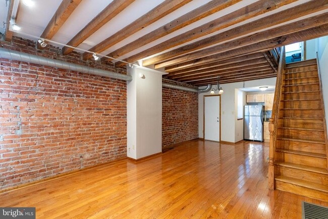
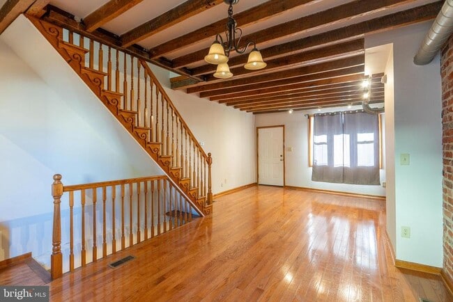
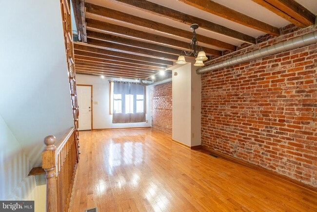
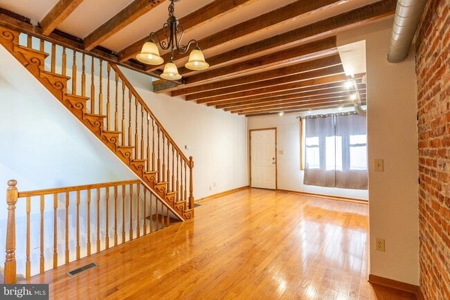
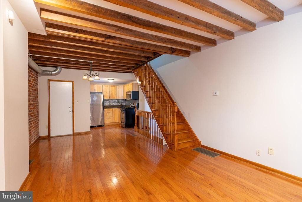
Wow don't miss this beauty!! Location, Location, Location! Central air washer dryer Stainless appliances and a beautiful brick wall too. This two bedroom with a larger main bedroom has what you need. Don't wait set your showing today.
2820 S Smedley St is a townhome located in Philadelphia County and the 19145 ZIP Code. This area is served by the The School District of Philadelphia attendance zone.
* Price shown is base rent. Excludes user-selected optional fees and variable or usage-based fees and required charges due at or prior to move-in or at move-out. Price, availability, fees, and any applicable rent special are subject to change without notice.
* Square footage definitions vary. Displayed square footage is approximate.
Home Details
Home Type
Interior Unit Townhome
Year Built
Built in 1920
Bedrooms and Bathrooms
2 Main Level Bedrooms
1 Full Bathroom
Home Design
Traditional Architecture
Masonry
Brick Foundation
Interior Spaces
838 Sq Ft Home
Property has 2 Levels
Listing and Financial Details
Security Deposit $1,750
12-Month Min and 24-Month Max Lease Term
Available 9/10/25
$50 Application Fee
Assessor Parcel Number 261348200
No Smoking Allowed
Coming Soon on 9/10/25
Residential Lease
Lot Details
741 Sq Ft Lot
Lot Dimensions are 14.00 x 52.00
Utilities
90% Forced Air Heating and Cooling System
Natural Gas Water Heater
No Septic System
Community Details
Overview
Marconi Park West Subdivision
Pet Policy
Cats Allowed
Limit on the number of pets
Pet Deposit $250
$25 Monthly Pet Rent
Contact
- Listed by Maria S Rosetti | Mercury Real Estate Group
- Phone Number
- Contact
-
Source
 Bright MLS, Inc.
Copyright © 2025 Bright MLS, Inc.
Location
Get Directions
Amenities
- Basement
If it's cheesesteaks and sports that piqued your interest in Philadelphia, you're looking for the neighborhood of South Philadelphia West. At its southeastern tip, this area borders the Wells Fargo Center and the Lincoln Financial Field, home of the Flyers and Phillies respectively. Located south of Moore Street, between busy Broad St. and the Schuykill River, the area offers a range of densely packed urban shopping districts and a riverfront oasis, all within minutes of Center City.
Bordered by Interstate 76 and 95, South Philly West encompasses several neighborhoods and entertainment hotspots. There’s a little something for everyone here, from the urban amenities of Melrose and South Philly, to FDR Park and the nearby Philadelphia International Airport.
Learn more about living in South Philadelphia West
Education
| Colleges & Universities | Distance | ||
|---|---|---|---|
| Colleges & Universities | Distance | ||
| Drive: | 8 min | 3.1 mi | |
| Drive: | 9 min | 3.4 mi | |
| Drive: | 7 min | 3.6 mi | |
| Drive: | 8 min | 3.8 mi |
2820 S Smedley St is within 8 minutes or 3.1 miles from The Art Inst. of Philadelphia. It is also near Thomas Jefferson University and University of Pennsylvania.
Schools


Public High School
Grades PK & 9-12
611 Students
Attendance Zone
Public Elementary & Middle School
Grades PK-8
248 Students
Attendance Zone
Private Elementary & Middle School
Grades PK-8
262 Students
Nearby
Private High School
Grades 9-12
690 Students
Nearby
School data provided by
 The GreatSchools Rating helps parents compare schools within a state based on a variety of school quality indicators and provides a helpful picture of how effectively each school serves all of its students. Ratings are on a scale of 1 (below average) to 10 (above average) and can include test scores, college readiness, academic progress, advanced courses, equity, discipline and attendance data. We also advise parents to visit schools, consider other information on school performance and programs, and consider family needs as part of the school selection process.
View GreatSchools Rating Methodology
Data provided by GreatSchools.org © 2025. All rights reserved.
View GreatSchools Rating Methodology
Data provided by GreatSchools.org © 2025. All rights reserved.
Transportation options available in Philadelphia include Oregon, located 0.2 mile from 2820 S Smedley St. 2820 S Smedley St is near Philadelphia International, located 6.5 miles or 14 minutes away, and Trenton Mercer, located 37.5 miles or 55 minutes away.
| Transit / Subway | Distance | ||
|---|---|---|---|
| Transit / Subway | Distance | ||
|
|
Walk: | 4 min | 0.2 mi |
|
|
Walk: | 14 min | 0.8 mi |
|
|
Walk: | 16 min | 0.8 mi |
|
|
Drive: | 4 min | 1.6 mi |
|
|
Drive: | 5 min | 1.9 mi |
| Commuter Rail | Distance | ||
|---|---|---|---|
| Commuter Rail | Distance | ||
|
|
Drive: | 9 min | 3.2 mi |
|
|
Drive: | 9 min | 3.4 mi |
| Drive: | 7 min | 3.5 mi | |
|
|
Drive: | 8 min | 3.7 mi |
|
|
Drive: | 7 min | 4.1 mi |
| Airports | Distance | ||
|---|---|---|---|
| Airports | Distance | ||
|
Philadelphia International
|
Drive: | 14 min | 6.5 mi |
|
Trenton Mercer
|
Drive: | 55 min | 37.5 mi |
Time and distance from 2820 S Smedley St.
| Shopping Centers | Distance | ||
|---|---|---|---|
| Shopping Centers | Distance | ||
| Walk: | 10 min | 0.5 mi | |
| Walk: | 13 min | 0.7 mi | |
| Walk: | 17 min | 0.9 mi |
2820 S Smedley St has 3 shopping centers within 0.9 mile, which is about a 17-minute walk. The miles and minutes will be for the farthest away property.
| Parks and Recreation | Distance | ||
|---|---|---|---|
| Parks and Recreation | Distance | ||
|
Franklin D. Roosevelt Park
|
Drive: | 5 min | 1.5 mi |
|
Thaddeus Kosciuszko National Memorial
|
Drive: | 8 min | 2.9 mi |
|
Gloria Dei Church National Historic Site
|
Drive: | 8 min | 2.9 mi |
|
Schuylkill River Park
|
Drive: | 8 min | 3.2 mi |
|
Bartram's Garden
|
Drive: | 9 min | 3.9 mi |
2820 S Smedley St has 5 parks within 3.9 miles, including Franklin D. Roosevelt Park, Gloria Dei Church National Historic Site, and Thaddeus Kosciuszko National Memorial.
| Hospitals | Distance | ||
|---|---|---|---|
| Hospitals | Distance | ||
| Walk: | 13 min | 0.7 mi | |
| Drive: | 9 min | 3.0 mi | |
| Drive: | 10 min | 3.6 mi |
2820 S Smedley St has 3 hospitals within 3.6 miles, the nearest is New Hanover Regional Medical Center which is 0.7 mile away and a 13 minute walk.
| Military Bases | Distance | ||
|---|---|---|---|
| Military Bases | Distance | ||
| Drive: | 5 min | 2.0 mi |
2820 S Smedley St is 2.0 miles and a 5 minute drive from Philadelphia Naval Busi Center.
You May Also Like
Similar Rentals Nearby


What Are Walk Score®, Transit Score®, and Bike Score® Ratings?
Walk Score® measures the walkability of any address. Transit Score® measures access to public transit. Bike Score® measures the bikeability of any address.
What is a Sound Score Rating?
A Sound Score Rating aggregates noise caused by vehicle traffic, airplane traffic and local sources
2820 S Smedley St
Philadelphia, PA 19145