
Vanguard
1001 Marshall Ave,
Cincinnati, OH 45219
Studio - 5 Beds $683 - $1,479
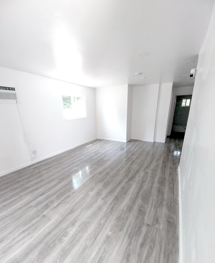

Be the first to live in something practically brand new! Discover your next home in Cincinnati, OH, a fully renovated 5-unit building nestled in the vibrant Westwood suburb. In 2023 everything was taken all the way down to the wood studs and renovated with all new electric, new plumbing, new drywall, new flooring, new everything! Each unit, designed with modern living in mind, offers a comfortable one-bedroom, one-bathroom. The building features brick construction ensuring a cozy and secure environment for all tenants. Located in the Cincinnati City School District, residents have access to several educational institutions, including Roll Hill School, and high schools like Western Hills, catering to a broad range of academic and extracurricular interests. The area boasts a convenient lifestyle with a mix of grocery stores, 22 restaurants, and 4 parks nearby, making daily errands and leisure activities easily accessible. Travel Times to Popular Destinations: • Cincinnati Children's Hospital Medical Center: • University of Cincinnati: 3.9 Miles / 8 Mins • Downtown Cincinnati: 5.4 Miles / 10 Mins • Over-the-Rhine District: 4.3 Miles / 11 Mins • Cincinnati Zoo & Botanical Garden: 5.2 Miles / 12 Mins • Cincinnati/Northern Kentucky International Airport (CVG): 17 Miles / 21 Mins
2751 Faber Ave is an apartment community located in Hamilton County and the 45211 ZIP Code. This area is served by the Cincinnati Public Schools attendance zone.
Aire acondicionado
Patio
Nevera
Bañera/Ducha
Situated about five miles northwest of Downtown Cincinnati, Westwood is the largest neighborhood in the city. Residents flock to Westwood for its many affordable historic homes and modern apartments available for rent in addition to its close proximity to I-74, I-75, and all that Downtown Cincinnati has to offer.
While Westwood is a predominantly residential neighborhood, it is also home to a slew of convenient stores and restaurants. Shopping opportunities abound in Westwood, with plenty of national retailers in Western Hills Plaza and local shops in the growing Town Hall District. Numerous neighborhood parks provide ample space to enjoy the outdoors in town as well as the sprawling 1,400-acre Mount Airy Forest, which is partially located in Westwood.
Learn more about living in Westwood| Colleges & Universities | Distance | ||
|---|---|---|---|
| Colleges & Universities | Distance | ||
| Drive: | 13 min | 4.5 mi | |
| Drive: | 11 min | 4.7 mi | |
| Drive: | 13 min | 5.2 mi | |
| Drive: | 15 min | 6.4 mi |


Transportation options available in Cincinnati include Brewery District Station, Elm & Henry, located 3.8 miles from 2751 Faber Ave. 2751 Faber Ave is near Cincinnati/Northern Kentucky International, located 18.1 miles or 33 minutes away.
| Transit / Subway | Distance | ||
|---|---|---|---|
| Transit / Subway | Distance | ||
| Drive: | 9 min | 3.8 mi | |
| Drive: | 9 min | 4.0 mi | |
| Drive: | 9 min | 4.1 mi | |
| Drive: | 9 min | 4.2 mi | |
| Drive: | 10 min | 4.3 mi |
| Commuter Rail | Distance | ||
|---|---|---|---|
| Commuter Rail | Distance | ||
|
|
Drive: | 9 min | 4.1 mi |
| Airports | Distance | ||
|---|---|---|---|
| Airports | Distance | ||
|
Cincinnati/Northern Kentucky International
|
Drive: | 33 min | 18.1 mi |
Time and distance from 2751 Faber Ave.
| Shopping Centers | Distance | ||
|---|---|---|---|
| Shopping Centers | Distance | ||
| Drive: | 5 min | 2.0 mi | |
| Drive: | 5 min | 2.3 mi | |
| Drive: | 6 min | 2.4 mi |
| Parks and Recreation | Distance | ||
|---|---|---|---|
| Parks and Recreation | Distance | ||
|
Imago Earth Center
|
Drive: | 10 min | 3.7 mi |
|
Mt. Airy Forest
|
Drive: | 10 min | 3.8 mi |
|
Wilson Commons
|
Drive: | 10 min | 4.0 mi |
|
Museum of Natural History and Science
|
Drive: | 9 min | 4.1 mi |
|
Cincinnati History Museum
|
Drive: | 9 min | 4.1 mi |
| Hospitals | Distance | ||
|---|---|---|---|
| Hospitals | Distance | ||
| Drive: | 10 min | 4.0 mi | |
| Drive: | 11 min | 4.5 mi | |
| Drive: | 12 min | 4.9 mi |
| Military Bases | Distance | ||
|---|---|---|---|
| Military Bases | Distance | ||
| Drive: | 74 min | 56.1 mi | |
| Drive: | 81 min | 61.1 mi | |
| Drive: | 83 min | 64.4 mi |
What Are Walk Score®, Transit Score®, and Bike Score® Ratings?
Walk Score® measures the walkability of any address. Transit Score® measures access to public transit. Bike Score® measures the bikeability of any address.
What is a Sound Score Rating?
A Sound Score Rating aggregates noise caused by vehicle traffic, airplane traffic and local sources
2751 Faber Ave
Cincinnati, OH 45211


