
$3,200
/ Month
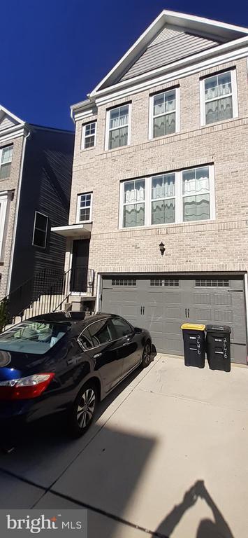
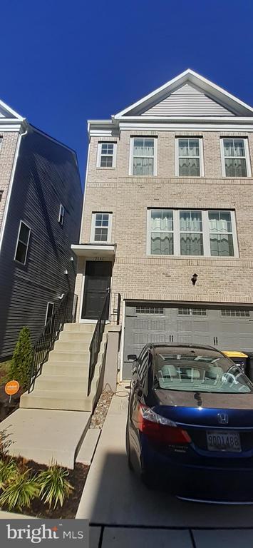
2646 Sierra Nevada Ave
Upper Marlboro, MD 20774
Today
Favorites
301-500-8670
-
Bedrooms
3
-
Bathrooms
3.5
-
Square Feet
--
-
Available
Available Now
Highlights
- Traditional Architecture
- 2 Car Direct Access Garage
- Level Entry For Accessibility
- Central Air
- ENERGY STAR Qualified Equipment for Heating
- Heating Available
2646 Sierra Nevada Ave

Favorites
About This Home
Available Now
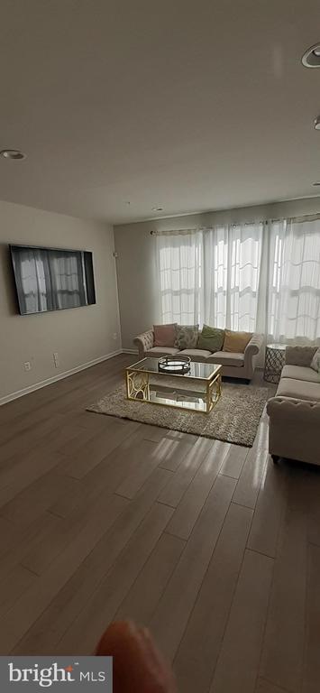
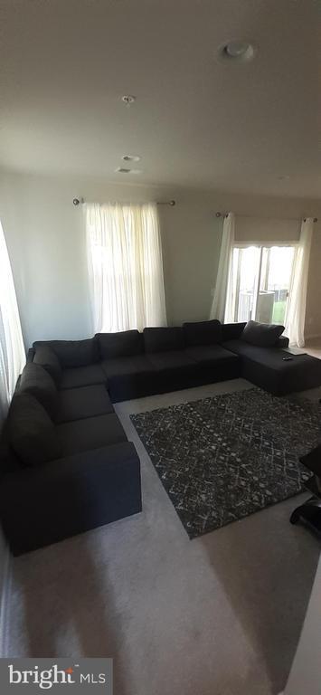
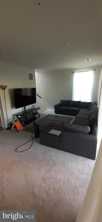
Spacious 3 Bedroom / 3.5 Bathroom Townhouse in Westphalia! This bright townhome boasts an oversized living room, fully modernized open kitchen and dining room, lower level rec room, 2 car garage and plenty accommodation. Sorry, no pets. Easy access to 495 and Suitland Parkway. Show anytime.
2646 Sierra Nevada Ave is a townhome located in Prince George's County and the 20774 ZIP Code. This area is served by the Prince George's County Public Schools attendance zone.
* Price shown is base rent and may not include non-optional fees and utilities. Price, availability, fees, and any applicable rent special are subject to change without notice.
* Square footage definitions vary. Displayed square footage is approximate.
Home Details
Home Type
End Unit Townhome
Year Built
Built in 2020
Accessible Home Design
Level Entry For Accessibility
Bedrooms and Bathrooms
3.5 Bathrooms
3 Bedrooms
Eco-Friendly Details
ENERGY STAR Qualified Equipment for Heating
Finished Basement
Rear Basement Entry
Home Design
Traditional Architecture
Brick Exterior Construction
Block Foundation
Interior Spaces
1,800 Sq Ft Home
Property has 3 Levels
Listing and Financial Details
Security Deposit $3,200
12-Month Min and 24-Month Max Lease Term
Available 9/1/25
Assessor Parcel Number 17065642830
Tenant pays for cable TV, internet, all utilities, minor interior maintenance
The owner pays for association fees, personal property taxes
No Smoking Allowed
Residential Lease
Lot Details
1,400 Sq Ft Lot
Parking
2 Car Direct Access Garage
Front Facing Garage
Utilities
Central Air
Heating Available
Natural Gas Water Heater
Cooling System Utilizes Natural Gas
Community Details
Overview
$70 Monthly HOA Fees
Westridge At Westphalia Subdivision
Pet Policy
No Pets Allowed
Contact
- Listed by STEVEN M NWAMKPA | Sold 100 Real Estate, Inc.
- Phone Number
- Contact
-
Source
 Bright MLS, Inc.
Copyright © 2025 Bright MLS, Inc.
Location
Get Directions
Amenities
- Basement
Moving to Upper Marlboro? You’ll be grateful for the close distance to nearby attractions and the sense of pride throughout the community. Located in Prince George’s County, the city is fused with urban and suburban amenities.
There’s much to enjoy about Upper Marlboro, and because it’s more intimate than other surrounding cities, it takes pride in putting on a series of events from homecoming games at local schools to show-stopping performances at the Show Place Arena. Darnall’s Chance House Museum is another city highlight that dates back to 1742.
Shopping in Upper Marlboro reflects the small, quaint ideology of the community. Fresh-baked goods and handmade crafts are purchased at the neighborhood Dutch Village Farmers Market. The distance to Washington D.C. gives residents a choice of either commuting into town by car or Metro rail.
Learn more about living in Upper Marlboro
Education
| Colleges & Universities | Distance | ||
|---|---|---|---|
| Colleges & Universities | Distance | ||
| Drive: | 11 min | 5.2 mi | |
| Drive: | 11 min | 5.7 mi | |
| Drive: | 23 min | 11.5 mi | |
| Drive: | 23 min | 12.3 mi |
2646 Sierra Nevada Ave is within 11 minutes or 5.2 miles from Prince George's Comm. Coll.. It is also near Univ. of Md. Univ. Coll. and Gallaudet University.
Schools


Public Elementary School
Grades PK-5
406 Students
Attendance Zone
Public Middle School
Grades 6-8
915 Students
Attendance Zone
Public High School
Grades 9-12
2,257 Students
Attendance Zone
Private Elementary & Middle School
Grades PK-8
26 Students
Nearby
Private High School
Grades 9-12
40 Students
Nearby
School data provided by
 The GreatSchools Rating helps parents compare schools within a state based on a variety of school quality indicators and provides a helpful picture of how effectively each school serves all of its students. Ratings are on a scale of 1 (below average) to 10 (above average) and can include test scores, college readiness, academic progress, advanced courses, equity, discipline and attendance data. We also advise parents to visit schools, consider other information on school performance and programs, and consider family needs as part of the school selection process.
View GreatSchools Rating Methodology
Data provided by GreatSchools.org © 2025. All rights reserved.
View GreatSchools Rating Methodology
Data provided by GreatSchools.org © 2025. All rights reserved.
Transportation options available in Upper Marlboro include Morgan Boulevard, located 4.4 miles from 2646 Sierra Nevada Ave. 2646 Sierra Nevada Ave is near Ronald Reagan Washington Ntl, located 15.9 miles or 30 minutes away, and Baltimore/Washington International Thurgood Marshall, located 30.7 miles or 47 minutes away.
| Transit / Subway | Distance | ||
|---|---|---|---|
| Transit / Subway | Distance | ||
|
|
Drive: | 10 min | 4.4 mi |
|
|
Drive: | 11 min | 5.1 mi |
|
|
Drive: | 11 min | 5.6 mi |
|
Capitol Heights, Blue/Silver Line Center Platform
|
Drive: | 13 min | 6.4 mi |
|
|
Drive: | 14 min | 7.0 mi |
| Commuter Rail | Distance | ||
|---|---|---|---|
| Commuter Rail | Distance | ||
| Drive: | 17 min | 9.5 mi | |
|
|
Drive: | 17 min | 9.5 mi |
|
|
Drive: | 17 min | 9.8 mi |
|
|
Drive: | 22 min | 11.7 mi |
|
|
Drive: | 23 min | 12.3 mi |
| Airports | Distance | ||
|---|---|---|---|
| Airports | Distance | ||
|
Ronald Reagan Washington Ntl
|
Drive: | 30 min | 15.9 mi |
|
Baltimore/Washington International Thurgood Marshall
|
Drive: | 47 min | 30.7 mi |
Time and distance from 2646 Sierra Nevada Ave.
| Shopping Centers | Distance | ||
|---|---|---|---|
| Shopping Centers | Distance | ||
| Drive: | 6 min | 2.4 mi | |
| Drive: | 8 min | 2.6 mi | |
| Drive: | 6 min | 2.6 mi |
2646 Sierra Nevada Ave has 3 shopping centers within 2.6 miles, which is about a 6-minute drive. The miles and minutes will be for the farthest away property.
| Parks and Recreation | Distance | ||
|---|---|---|---|
| Parks and Recreation | Distance | ||
|
Walker Mill Regional Park
|
Drive: | 7 min | 3.1 mi |
|
Suitland Bog
|
Drive: | 11 min | 5.1 mi |
|
Watkins Nature Center
|
Drive: | 11 min | 5.7 mi |
|
Old Maryland Farm
|
Drive: | 12 min | 5.8 mi |
|
Watkins Regional Park
|
Drive: | 16 min | 6.7 mi |
2646 Sierra Nevada Ave has 5 parks within 6.7 miles, including Walker Mill Regional Park, Suitland Bog, and Watkins Nature Center.
| Hospitals | Distance | ||
|---|---|---|---|
| Hospitals | Distance | ||
| Drive: | 18 min | 9.6 mi | |
| Drive: | 21 min | 10.7 mi | |
| Drive: | 20 min | 11.3 mi |
2646 Sierra Nevada Ave has 3 hospitals within 11.3 miles, the nearest is University of Maryland Prince George's Hospital Center which is 9.6 miles away and a 18 minute drive.
| Military Bases | Distance | ||
|---|---|---|---|
| Military Bases | Distance | ||
| Drive: | 12 min | 5.5 mi | |
| Drive: | 21 min | 10.7 mi |
2646 Sierra Nevada Ave is 5.5 miles from Andrews Airforce Base, and is convenient to other military bases, including Washington Navy Yard.
You May Also Like
Similar Rentals Nearby


What Are Walk Score®, Transit Score®, and Bike Score® Ratings?
Walk Score® measures the walkability of any address. Transit Score® measures access to public transit. Bike Score® measures the bikeability of any address.
What is a Sound Score Rating?
A Sound Score Rating aggregates noise caused by vehicle traffic, airplane traffic and local sources
2646 Sierra Nevada Ave
Upper Marlboro, MD 20774