
The Vitagraph
1277 E 14th St,
Brooklyn, NY 11230
$3,389 - $3,802
2-3 Beds

Building description is coming soon..
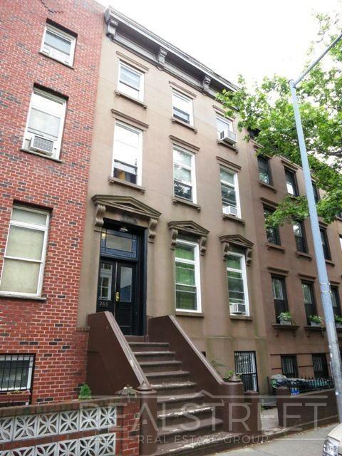
260 Union Street is an apartment community located in Kings County and the 11231 ZIP Code. This area is served by the New York City Geographic District #15 attendance zone.
Neighboring Boerum Hill and Cobble Hill in Brooklyn, Carroll Gardens is equal parts historic and hip. Classic brownstones and modern high-rise apartments comprise the bulk of the rental options in Carroll Gardens. While the neighborhood is distinctly urban, Carroll Gardens embraces the outdoors with lush tree-lined streets and numerous community parks.
Carroll Gardens is home to a close-knit community, which supports a thriving small business scene. Residents enjoy access to a host of popular restaurants, unique boutiques, cozy cafes, artisanal food shops, local pizzerias, hip bars, and great public schools in the neighborhood. Getting around from Carroll Gardens is easy with its walkable design and quick access to I-278, I-478, and multiple subway stations.
Learn more about living in Carroll Gardens| Colleges & Universities | Distance | ||
|---|---|---|---|
| Colleges & Universities | Distance | ||
| Walk: | 17 min | 0.9 mi | |
| Walk: | 19 min | 1.0 mi | |
| Drive: | 4 min | 1.3 mi | |
| Drive: | 5 min | 1.4 mi |


Transportation options available in Brooklyn include Carroll Street, located 0.3 mile from 260 Union Street. 260 Union Street is near LaGuardia, located 10.7 miles or 21 minutes away, and Newark Liberty International, located 15.4 miles or 27 minutes away.
| Transit / Subway | Distance | ||
|---|---|---|---|
| Transit / Subway | Distance | ||
|
|
Walk: | 5 min | 0.3 mi |
|
|
Walk: | 11 min | 0.6 mi |
|
|
Walk: | 14 min | 0.7 mi |
|
|
Walk: | 17 min | 0.9 mi |
|
|
Walk: | 19 min | 1.0 mi |
| Commuter Rail | Distance | ||
|---|---|---|---|
| Commuter Rail | Distance | ||
|
|
Drive: | 6 min | 1.8 mi |
|
|
Drive: | 9 min | 3.2 mi |
|
|
Drive: | 12 min | 5.0 mi |
|
|
Drive: | 17 min | 6.6 mi |
|
|
Drive: | 19 min | 7.1 mi |
| Airports | Distance | ||
|---|---|---|---|
| Airports | Distance | ||
|
LaGuardia
|
Drive: | 21 min | 10.7 mi |
|
Newark Liberty International
|
Drive: | 27 min | 15.4 mi |
Time and distance from 260 Union Street.
| Shopping Centers | Distance | ||
|---|---|---|---|
| Shopping Centers | Distance | ||
| Drive: | 5 min | 1.7 mi | |
| Drive: | 5 min | 1.9 mi | |
| Drive: | 9 min | 3.3 mi |
| Parks and Recreation | Distance | ||
|---|---|---|---|
| Parks and Recreation | Distance | ||
|
Cobble Hill Park
|
Walk: | 9 min | 0.5 mi |
|
Gowanus Canal
|
Walk: | 12 min | 0.7 mi |
|
Red Hook Park
|
Drive: | 2 min | 1.1 mi |
|
Coffey Park
|
Drive: | 4 min | 1.5 mi |
|
Cadman Plaza Park
|
Drive: | 4 min | 1.5 mi |
| Hospitals | Distance | ||
|---|---|---|---|
| Hospitals | Distance | ||
| Drive: | 5 min | 1.7 mi | |
| Drive: | 6 min | 2.2 mi | |
| Drive: | 11 min | 3.9 mi |
| Military Bases | Distance | ||
|---|---|---|---|
| Military Bases | Distance | ||
| Drive: | 10 min | 4.5 mi | |
| Drive: | 25 min | 12.8 mi |
What Are Walk Score®, Transit Score®, and Bike Score® Ratings?
Walk Score® measures the walkability of any address. Transit Score® measures access to public transit. Bike Score® measures the bikeability of any address.
What is a Sound Score Rating?
A Sound Score Rating aggregates noise caused by vehicle traffic, airplane traffic and local sources
260 Union St
Brooklyn, NY 11231


