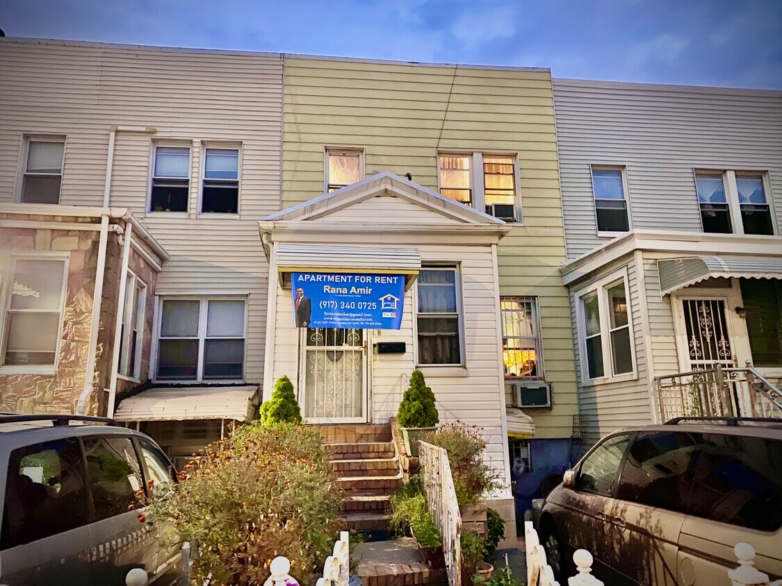
249 Dahill Rd
249 Dahill Rd,
Brooklyn,
NY
11218
2 Weeks Ago
Favorites
249 Dahill Rd

Favorites
Check Back Soon for Upcoming Availability
Fees and Policies
The fees below are based on community-supplied data and may exclude additional fees and utilities.
Details
Utilities Included
-
Water
-
Sewer
Lease Options
-
12 Months
Property Information
-
Furnished Units Available
About 249 Dahill Rd Brooklyn, NY 11218
Location! Location! Location! *First Fl and Lower Level* for rent in the heart of KENSINGTON, BROOKLYN! In a well maintained private home the apartment(s) include: 2 large bedrooms STUDIO, 2 FULL bathrooms, hardwood floors, tiled floors, a spacey kitchen, living room, and a usable BACKYARD! Adjacent to all transportation,(B35, B67, F and G Trains), restaurants, supermarkets, schools, parks, laundromats, and a busy yet amazing community, this apartment is truly a great deal for a family or a couple here in Brooklyn, NY.
249 Dahill Rd is an apartment community located in Kings County and the 11218 ZIP Code.
Apartment Features
- Smoke Free
- Furnished
Location
Get Directions
Borough Park offers a slightly quieter atmosphere in a scenic New York setting just west of Long Island. The area’s peaceful blocks are shared by renters of all types enjoying an easy-going Brooklyn lifestyle. The quiet streets and charming historic homes make planting roots in the area an attractive option. This classically Brooklyn area is home to dense blocks of brick apartments buildings and buzzing local businesses. Prospect Park is just a few blocks walk to the northeast. Subway service abounds in this exciting Brooklyn neighborhood, putting the rest of arguably NYC’s most exciting borough at your fingertips, with Manhattan just a 30-minute train ride away as well.
Learn more about living in Borough ParkBelow are rent ranges for similar nearby apartments
Amenities
- Smoke Free
- Furnished
Expenses
Utilities Included
Water, Sewer
Included
Education
| Colleges & Universities | Distance | ||
|---|---|---|---|
| Colleges & Universities | Distance | ||
| Drive: | 7 min | 2.3 mi | |
| Drive: | 7 min | 2.7 mi | |
| Drive: | 10 min | 4.3 mi | |
| Drive: | 10 min | 4.5 mi |
249 Dahill Rd is within 7 minutes or 2.3 miles from Brooklyn College. It is also near Medgar Evers College, CUNY and Saint Joseph's Coll, Brooklyn.
Transportation options available in Brooklyn include Church Avenue (F,G Line), located 0.2 mile from 249 Dahill Rd. 249 Dahill Rd is near John F Kennedy International, located 12.8 miles or 23 minutes away, and Newark Liberty International, located 18.5 miles or 30 minutes away.
| Transit / Subway | Distance | ||
|---|---|---|---|
| Transit / Subway | Distance | ||
|
|
Walk: | 4 min | 0.2 mi |
|
|
Walk: | 7 min | 0.4 mi |
|
|
Walk: | 17 min | 0.9 mi |
|
|
Drive: | 2 min | 1.3 mi |
|
|
Drive: | 3 min | 1.3 mi |
| Commuter Rail | Distance | ||
|---|---|---|---|
| Commuter Rail | Distance | ||
|
|
Drive: | 10 min | 3.9 mi |
|
|
Drive: | 9 min | 4.0 mi |
|
|
Drive: | 12 min | 5.5 mi |
|
|
Drive: | 21 min | 9.3 mi |
|
|
Drive: | 23 min | 9.9 mi |
| Airports | Distance | ||
|---|---|---|---|
| Airports | Distance | ||
|
John F Kennedy International
|
Drive: | 23 min | 12.8 mi |
|
Newark Liberty International
|
Drive: | 30 min | 18.5 mi |
Time and distance from 249 Dahill Rd.
| Shopping Centers | Distance | ||
|---|---|---|---|
| Shopping Centers | Distance | ||
| Walk: | 20 min | 1.0 mi | |
| Drive: | 5 min | 1.5 mi | |
| Drive: | 6 min | 1.5 mi |
249 Dahill Rd has 3 shopping centers within 1.5 miles, which is about a 6-minute walk. The miles and minutes will be for the farthest away property.
| Parks and Recreation | Distance | ||
|---|---|---|---|
| Parks and Recreation | Distance | ||
|
Sunset Park
|
Drive: | 4 min | 1.9 mi |
|
Prospect Park Audubon Center at the Boathouse
|
Drive: | 4 min | 2.0 mi |
|
Prospect Park Zoo
|
Drive: | 4 min | 2.1 mi |
|
Brooklyn Botanic Garden
|
Drive: | 5 min | 2.5 mi |
|
Prospect Park
|
Drive: | 8 min | 3.1 mi |
249 Dahill Rd has 5 parks within 3.1 miles, including Sunset Park, Prospect Park Zoo, and Prospect Park.
| Hospitals | Distance | ||
|---|---|---|---|
| Hospitals | Distance | ||
| Drive: | 4 min | 1.6 mi | |
| Drive: | 6 min | 2.3 mi | |
| Drive: | 6 min | 2.7 mi |
249 Dahill Rd has 3 hospitals within 2.7 miles, the nearest is Maimonides Medical Center which is 1.6 miles away and a 4 minute drive.
| Military Bases | Distance | ||
|---|---|---|---|
| Military Bases | Distance | ||
| Drive: | 11 min | 4.6 mi | |
| Drive: | 12 min | 7.0 mi |
249 Dahill Rd is 4.6 miles from Fort Hamilton, and is convenient to other military bases, including Governors Island Support Center.
You May Also Like
Similar Rentals Nearby


What Are Walk Score®, Transit Score®, and Bike Score® Ratings?
Walk Score® measures the walkability of any address. Transit Score® measures access to public transit. Bike Score® measures the bikeability of any address.
What is a Sound Score Rating?
A Sound Score Rating aggregates noise caused by vehicle traffic, airplane traffic and local sources