

$1,395
/ Month
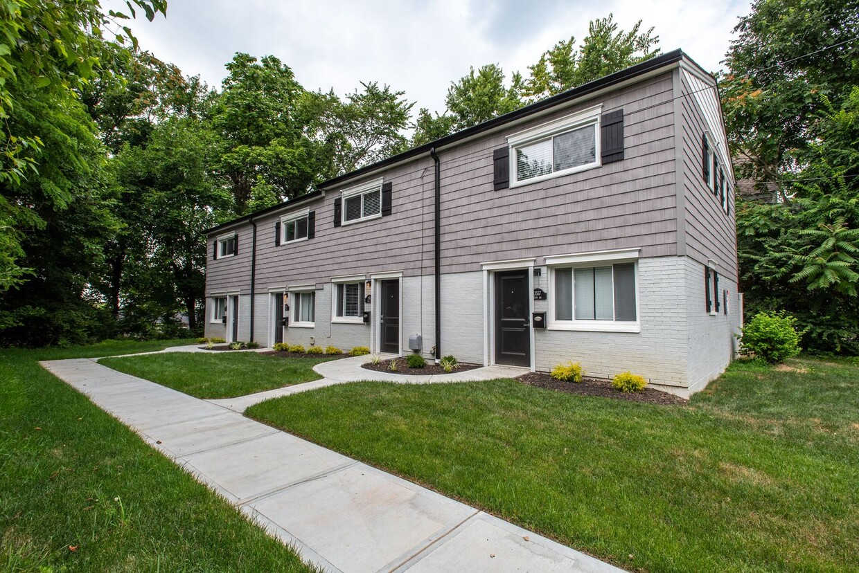
244 Irwin Pl
Cincinnati, OH 45229
2 Weeks Ago
|
Edit
Favorites
244 Irwin Pl

Favorites
Check Back Soon for Upcoming Availability
| Beds | Baths | Average SF |
|---|---|---|
| 2 Bedrooms 2 Bedrooms 2 Br | 1 Bath 1 Bath 1 Ba | 850 SF |
About This Property
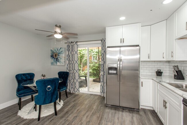
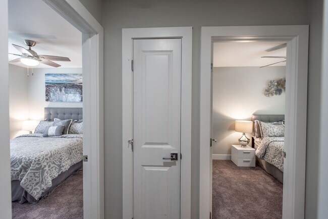
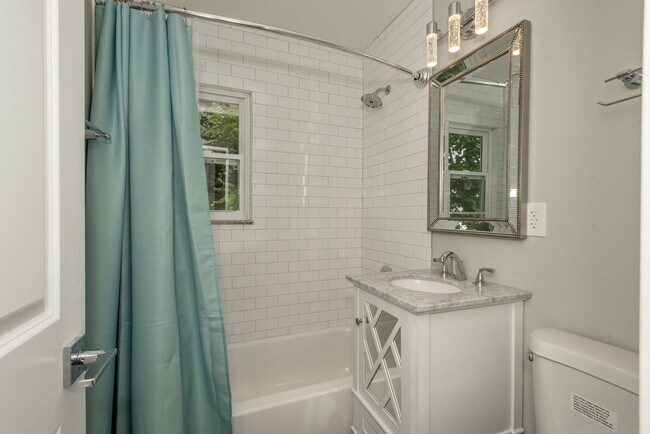
**ASK ABOUT OUR MOVE-IN SPECIAL** Minutes from UC hospital, Children's Hospital, Cincinnati Zoo University of Cincinnati and Xavier. 10 minutes to downtown. Come See Our Renovated 2 bdrm / 1 bth townhomes featuring High End Finishes thru-out, including Fully equipped kitchens w/granite countertops, stainless steel appliances and a sliding patio door to your private rear patio, 1st floor "all-in-one" washer/dryer hookup pantry is located off the Kitchen, the 2nd floor features 2 spacious bedrooms separated by a fully updated bathroom w/ additional linen storage. We also have off street parking. Request a tour today! Apply online via
244 Irwin Pl is a townhome located in Hamilton County and the 45229 ZIP Code. This area is served by the Cincinnati Public Schools attendance zone.
244 Irwin Pl,
Cincinnati,
OH
45229
Cincinnati sits on the northern bank of the Ohio River, where rolling hills meet a city that helped establish the Midwest long before other major metros existed. Settled in 1788, the Queen City sits west of the Appalachian Mountains and combines historic culture with urban living.
Today, neighborhoods like Over-the-Rhine, Hyde Park, and Mount Adams each bring a distinct character to city life. Over-the-Rhine is packed with restored 19th-century architecture, Findlay Market, and Music Hall. Mount Adams perches beside Eden Park with stunning river views, while Hyde Park Square draws locals and tourists alike with local cafes and walkable streets.
Renters will find a wide range of housing options across the city, from converted lofts and townhouses in Over-the-Rhine to sleek high-rise apartment communities along the riverfront at The Banks. Clifton and Oakley offer everything from charming older buildings to newer developments with modern amenities.
Learn more about living in CincinnatiBelow are rent ranges for similar nearby apartments
Education
| Colleges & Universities | Distance | ||
|---|---|---|---|
| Colleges & Universities | Distance | ||
| Drive: | 4 min | 1.3 mi | |
| Drive: | 4 min | 1.3 mi | |
| Drive: | 6 min | 2.0 mi | |
| Drive: | 9 min | 2.9 mi |
244 Irwin Pl is within 4 minutes or 1.3 miles from Univ. of Cincinnati, Medical. It is also near University of Cincinnati and Xavier University.
Schools


Public Elementary, Middle & High School
Grades K-12
Attendance Zone
Public Elementary School
Grades PK-5
Attendance Zone
Public Middle & High School
Grades 6-12
Attendance Zone
Private Elementary & Middle School
Grades PK-8
Nearby
Private Elementary & Middle School
Grades PK-8
Nearby
Private High School
Grades 9-12
Nearby
School data provided by
 The GreatSchools Rating helps parents compare schools within a state based on a variety of school quality indicators and provides a helpful picture of how effectively each school serves all of its students. Ratings are on a scale of 1 (below average) to 10 (above average) and can include test scores, college readiness, academic progress, advanced courses, equity, discipline and attendance data. We also advise parents to visit schools, consider other information on school performance and programs, and consider family needs as part of the school selection process.
View GreatSchools Rating Methodology
Data provided by GreatSchools.org © 2026. All rights reserved.
View GreatSchools Rating Methodology
Data provided by GreatSchools.org © 2026. All rights reserved.
Transportation options available in Cincinnati include Findlay Market-Race Station - Race & Elder, located 2.8 miles from 244 Irwin Pl. 244 Irwin Pl is near Cincinnati/Northern Kentucky International, located 18.4 miles or 35 minutes away.
| Transit / Subway | Distance | ||
|---|---|---|---|
| Transit / Subway | Distance | ||
| Drive: | 8 min | 2.8 mi | |
| Drive: | 8 min | 2.9 mi | |
| Drive: | 9 min | 2.9 mi | |
| Drive: | 9 min | 3.0 mi | |
| Drive: | 10 min | 3.3 mi |
| Commuter Rail | Distance | ||
|---|---|---|---|
| Commuter Rail | Distance | ||
|
|
Drive: | 12 min | 5.2 mi |
| Airports | Distance | ||
|---|---|---|---|
| Airports | Distance | ||
|
Cincinnati/Northern Kentucky International
|
Drive: | 35 min | 18.4 mi |
Walkability Near 244 Irwin Pl Cincinnati, OH 45229
Getting Around
 What do Walkability, Transit, Drivability, and Bikeability mean?
Walkability measures the walking distance to day-to-day needs.
Transit measures access to public transportation.
Drivability measures congestion, parking availability, and access to major roads.
Bikeability measures the suitability for cycling.
How It Works
What do Walkability, Transit, Drivability, and Bikeability mean?
Walkability measures the walking distance to day-to-day needs.
Transit measures access to public transportation.
Drivability measures congestion, parking availability, and access to major roads.
Bikeability measures the suitability for cycling.
How It Works
Moderately Walkable
Walkability
70
/ 100
Limited Public Transit
Transit
30
/ 100
Very Drivable
Drivability
80
/ 100
Fairly Bikeable
Bikeability
40
/ 100
Scores provided by
-
Soundscore™
-
/ 100
Traffic
-Airport
-Businesses
-Scores provided by
HowLoud What is a Sound Score Rating? A Sound Score Rating aggregates noise caused by vehicle traffic, airplane traffic and local sources. How It WorksTime and distance from 244 Irwin Pl.
| Shopping Centers | Distance | ||
|---|---|---|---|
| Shopping Centers | Distance | ||
| Walk: | 17 min | 0.9 mi | |
| Drive: | 6 min | 2.3 mi | |
| Drive: | 8 min | 2.7 mi |
244 Irwin Pl has 3 shopping centers within 2.7 miles, which is about a 8-minute drive. The miles and minutes will be for the farthest away property.
| Parks and Recreation | Distance | ||
|---|---|---|---|
| Parks and Recreation | Distance | ||
|
Cincinnati Zoo and Botanical Garden
|
Walk: | 14 min | 0.7 mi |
|
Burnet Woods
|
Drive: | 4 min | 1.4 mi |
|
Trailside Nature Center
|
Drive: | 6 min | 1.7 mi |
|
Avon Woods Natural Area/Preserve
|
Drive: | 6 min | 2.4 mi |
|
William H. Taft National Historic Site
|
Drive: | 8 min | 2.6 mi |
244 Irwin Pl has 5 parks within 2.6 miles, including Cincinnati Zoo and Botanical Garden, Burnet Woods, and Trailside Nature Center.
| Hospitals | Distance | ||
|---|---|---|---|
| Hospitals | Distance | ||
| Walk: | 14 min | 0.7 mi | |
| Walk: | 18 min | 1.0 mi | |
| Drive: | 3 min | 1.1 mi |
244 Irwin Pl has 3 hospitals within 1.1 miles, the nearest is Cincinnati Children's Hospital Medical Center which is 0.7 mile away and a 14 minute walk.
| Military Bases | Distance | ||
|---|---|---|---|
| Military Bases | Distance | ||
| Drive: | 67 min | 50.8 mi | |
| Drive: | 73 min | 55.9 mi | |
| Drive: | 76 min | 59.1 mi |
244 Irwin Pl has 3 military bases within 59.1 miles, the nearest is Gentile Air Force Station which is 50.8 miles away and a 67 minute drive.
You May Also Like
Similar Rentals Nearby


What Are Walk Score®, Transit Score®, and Bike Score® Ratings?
Walk Score® measures the walkability of any address. Transit Score® measures access to public transit. Bike Score® measures the bikeability of any address.
What is a Sound Score Rating?
A Sound Score Rating aggregates noise caused by vehicle traffic, airplane traffic and local sources.
244 Irwin Pl
Cincinnati, OH 45229