
24 State St Unit 2
24 State St Unit 2
Wellesley, MA 02482
2 Weeks Ago
Favorites
24 State St Unit 2

Favorites
Check Back Soon for Upcoming Availability
| Beds | Baths | Average SF |
|---|---|---|
| 3 Bedrooms 3 Bedrooms 3 Br | 2 Baths 2 Baths 2 Ba | — |
About This Property
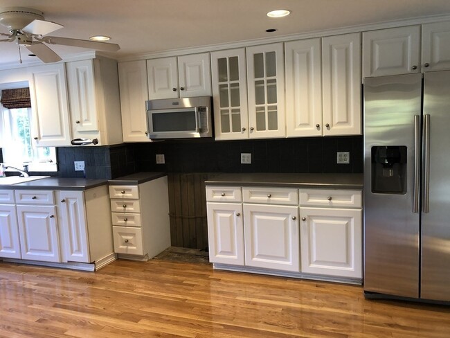
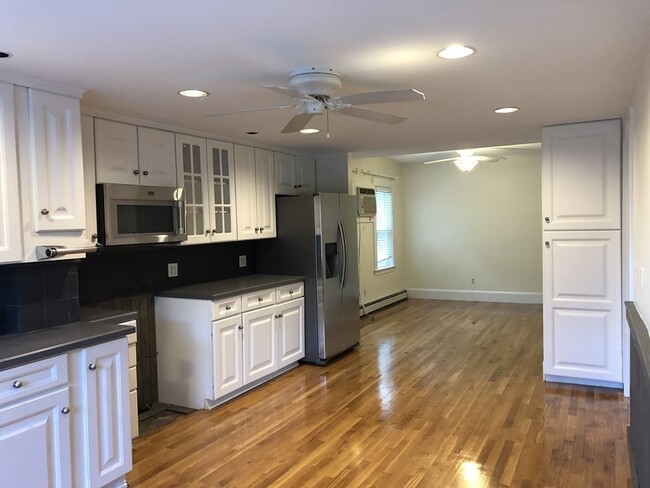
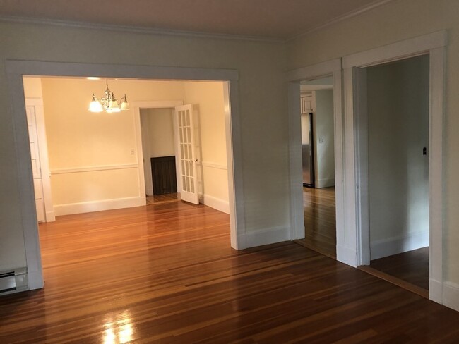
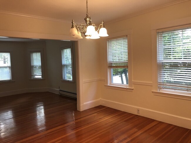
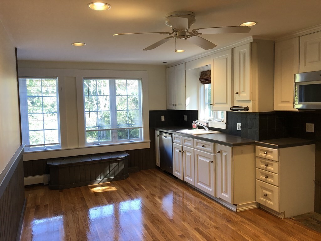
Terrific location! Walk to commuter rail. Whole Foods,restaurants shopping and more! The Wellesley Brook path is steps away. This is the second and third floor of a three family home. New carpeting in hallways. Recently remodeled kitchen overlooking the family room,stainless steel refrigerator,microwave,stove,plenty of cabinets. Open floor plan; front to back living in dining room. Bonus room,front facing with hardwood floors (extra den/library). Two car assigned driving parking. Tenant is responsible for heat,electricity,utilities and Internet. Water,landscaping and snow removal included don’t miss!
24 State St is an apartment community located in Norfolk County and the 02482 ZIP Code.
Location
Get Directions
Just west of Boston and East of Worcester sits Metro West, a region that houses a group of towns and cities with significant historical backgrounds. A total of 19 municipalities make up the core of this community, but other municipalities are considered to be a part of the Interstate 495/Metro West Corridor.
Learn more about living in Metro WestBelow are rent ranges for similar nearby apartments
| Beds | Average Size | Lowest | Typical | Premium |
|---|---|---|---|---|
| Studio Studio Studio | 609-611 Sq Ft | $1,125 | $2,221 | $3,630 |
| 1 Bed 1 Bed 1 Bed | 876-877 Sq Ft | $850 | $2,847 | $9,583 |
| 2 Beds 2 Beds 2 Beds | 1270-1271 Sq Ft | $1,775 | $3,569 | $17,713 |
| 3 Beds 3 Beds 3 Beds | 1552-1556 Sq Ft | $1,000 | $4,741 | $20,263 |
| 4 Beds 4 Beds 4 Beds | 3826 Sq Ft | $1,210 | $6,552 | $30,000 |
Education
| Colleges & Universities | Distance | ||
|---|---|---|---|
| Colleges & Universities | Distance | ||
| Drive: | 4 min | 1.4 mi | |
| Drive: | 5 min | 1.7 mi | |
| Drive: | 13 min | 5.9 mi | |
| Drive: | 15 min | 8.0 mi |
24 State St Unit 2 is within 4 minutes or 1.4 miles from Babson College. It is also near Wellesley College and Brandeis University.
Transportation options available in Wellesley include Woodland Station, located 3.4 miles from 24 State St Unit 2. 24 State St Unit 2 is near General Edward Lawrence Logan International, located 17.4 miles or 28 minutes away, and Worcester Regional, located 32.5 miles or 55 minutes away.
| Transit / Subway | Distance | ||
|---|---|---|---|
| Transit / Subway | Distance | ||
|
|
Drive: | 6 min | 3.4 mi |
|
|
Drive: | 8 min | 3.5 mi |
|
|
Drive: | 8 min | 4.1 mi |
|
|
Drive: | 9 min | 4.7 mi |
|
|
Drive: | 9 min | 4.9 mi |
| Commuter Rail | Distance | ||
|---|---|---|---|
| Commuter Rail | Distance | ||
|
|
Walk: | 16 min | 0.9 mi |
|
|
Walk: | 19 min | 1.0 mi |
|
|
Drive: | 5 min | 2.1 mi |
|
|
Drive: | 6 min | 3.1 mi |
|
|
Drive: | 8 min | 3.1 mi |
| Airports | Distance | ||
|---|---|---|---|
| Airports | Distance | ||
|
General Edward Lawrence Logan International
|
Drive: | 28 min | 17.4 mi |
|
Worcester Regional
|
Drive: | 55 min | 32.5 mi |
Time and distance from 24 State St Unit 2.
| Shopping Centers | Distance | ||
|---|---|---|---|
| Shopping Centers | Distance | ||
| Walk: | 2 min | 0.1 mi | |
| Walk: | 9 min | 0.5 mi | |
| Walk: | 13 min | 0.7 mi |
24 State St Unit 2 has 3 shopping centers within 0.7 mile, which is about a 13-minute walk. The miles and minutes will be for the farthest away property.
| Parks and Recreation | Distance | ||
|---|---|---|---|
| Parks and Recreation | Distance | ||
|
Whitin Observatory
|
Drive: | 3 min | 1.2 mi |
|
Wellesley College Botanic Gardens
|
Drive: | 2 min | 1.4 mi |
|
Weezie's Garden for Children
|
Drive: | 8 min | 2.9 mi |
|
Elm Bank Reservation
|
Drive: | 8 min | 2.9 mi |
|
Horticultural Society at Elm Bank
|
Drive: | 9 min | 3.1 mi |
24 State St Unit 2 has 5 parks within 3.1 miles, including Whitin Observatory, Wellesley College Botanic Gardens, and Horticultural Society at Elm Bank.
| Hospitals | Distance | ||
|---|---|---|---|
| Hospitals | Distance | ||
| Drive: | 5 min | 3.1 mi | |
| Drive: | 6 min | 3.3 mi | |
| Drive: | 13 min | 6.3 mi |
24 State St Unit 2 has 3 hospitals within 6.3 miles, the nearest is Newton - Wellesley Hospital which is 3.1 miles away and a 5 minute drive.
| Military Bases | Distance | ||
|---|---|---|---|
| Military Bases | Distance | ||
| Drive: | 8 min | 4.3 mi | |
| Drive: | 24 min | 13.3 mi |
24 State St Unit 2 is 4.3 miles from US Military Reservation, and is convenient to other military bases, including Hanscom Air Force Base.
You May Also Like
Similar Rentals Nearby
-
-
-
$4,809 - $5,533
Total Monthly Price3 Beds
1 Month FreePets Allowed Fitness Center Pool In Unit Washer & Dryer Clubhouse Stainless Steel Appliances EV Charging
-
-
-
-
-
-
-


What Are Walk Score®, Transit Score®, and Bike Score® Ratings?
Walk Score® measures the walkability of any address. Transit Score® measures access to public transit. Bike Score® measures the bikeability of any address.
What is a Sound Score Rating?
A Sound Score Rating aggregates noise caused by vehicle traffic, airplane traffic and local sources
24 State St
Wellesley, MA 02482