

$3,050 / Month
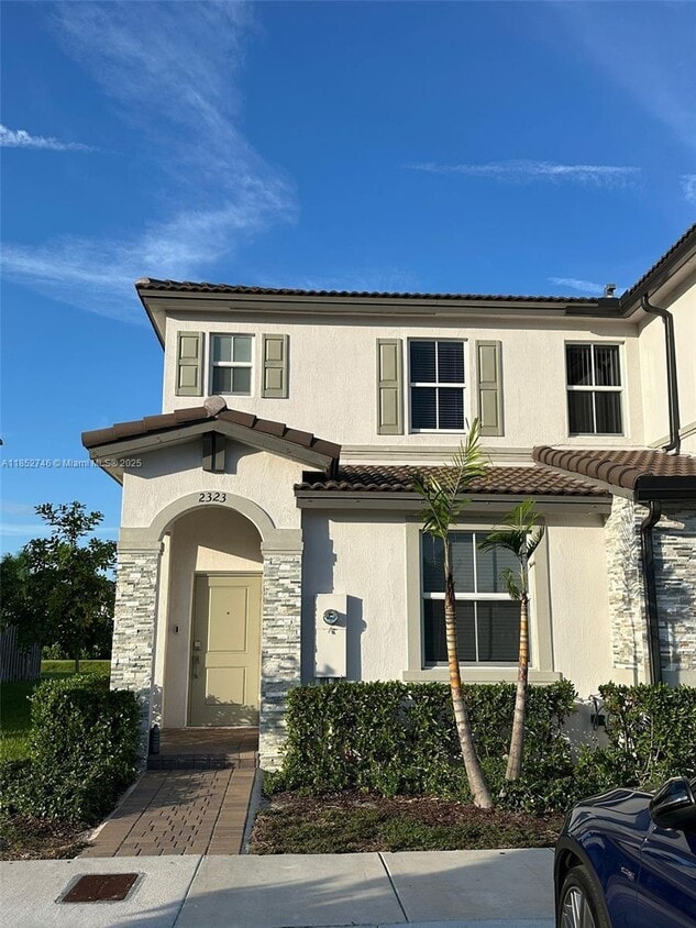
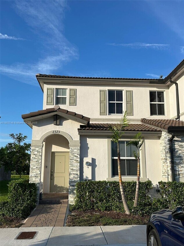
2323 NW 122nd Ter
Miami Shores, FL 33167
Today
Favorites
954-544-6816
-
Bedrooms
3
-
Bathrooms
3
-
Square Feet
1,328 sq ft
-
Available
Available Aug 9
Highlights
- Home fronts a canal
- High Impact Windows
- Central Heating and Cooling System
- 2 Car Garage
2323 NW 122nd Ter

Favorites
About This Home
Available Aug 9
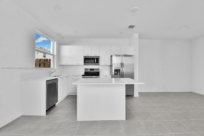
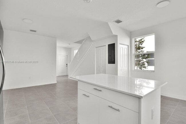
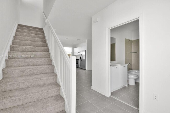
Discover your new home in Miami’s sought-after Westview community! This stunning, newly built 3 bed/3 bath residence offers an open-concept kitchen with stainless steel appliances, quartz countertops, and sleek white cabinetry. Enjoy the convenience of a first-floor bedroom and full bath, plus an upstairs primary suite with walk-in closet and spa-like ensuite, and a second bedroom with private bath. Laundry is upstairs for ease. Perfectly located between Miami-Dade and Broward, just minutes from North Miami, Aventura, Hialeah, Downtown, Wynwood, Pembroke Pines, and major highways. Section 8 welcome to apply, good credit required per HOA.
2323 NW 122nd Ter is a house located in Miami/Dade County and the 33167 ZIP Code. This area is served by the Miami-Dade County Public Schools attendance zone.
* Price shown is base rent and may not include non-optional fees and utilities.
Price, availability, fees, and any applicable rent special are subject to change without notice.
* Square footage definitions vary. Displayed square footage is approximate.
Home Details
Home Type
Single Family Detached Home
Year Built
Built in 2023
Bedrooms and Bathrooms
3 Full Bathrooms
3 Bedrooms
Home Security
High Impact Windows
Interior Spaces
1,328 Sq Ft Home
Kitchen
Electric Range
Microwave
Dishwasher
Listing and Financial Details
Property Available on 9/1/25
Assessor Parcel Number 30-21-27-034-2650
Lot Details
1,829 Sq Ft Lot
Home fronts a canal
Property is zoned 9400
Parking
2 Car Garage
Utilities
Central Heating and Cooling System
Community Details
Overview
No Home Owners Association
Golf Park Sec 1 Condos
Golf Park Sec 1 Subdivision
Pet Policy
Breed Restrictions
Fees and Policies
The fees below are based on community-supplied data and may exclude additional fees and utilities.
- Dogs Allowed
-
Fees not specified
- Cats Allowed
-
Fees not specified
Contact
- Listed by Rafael Beltran Escobar | Compass Florida, LLC.
- Phone Number
- Contact
-
Source
 MIAMI Association of REALTORS®
Copyright © 2025 MIAMI Association of REALTORS®. All rights reserved. All information provided by the listing agent/broker is deemed reliable but is not guaranteed and should be independently verified.
Location
Get Directions
Amenities
- Waterfront
Miami Shores is a densely populated area off the Biscayne Bay. Miami Shores is largely residential featuring an array of condos, single-family houses, and apartments for rent. The community is anchored by the Miami Shores Recreation Department Park. This green space is home to a golf course, an aquatic center, and sports fields. For scenic views of the bay, head to North Bayshore Park. To get to classic Miami Beaches, head about six miles east across the John F Kennedy Causeway. A few shops and stores dot the areas within Miami Shores, but an abundance of shopping and dining choices are situated just south of town. Keep heading south of the community for 10 miles to get to Downtown Miami’s electric streets.
Learn more about living in Miami Shores
Education
| Colleges & Universities | Distance | ||
|---|---|---|---|
| Colleges & Universities | Distance | ||
| Drive: | 8 min | 2.6 mi | |
| Drive: | 11 min | 3.9 mi | |
| Drive: | 11 min | 4.0 mi | |
| Drive: | 12 min | 4.6 mi |
2323 NW 122nd Ter is within 8 minutes or 2.6 miles from Miami Dade College, North. It is also near Barry University and Saint Thomas University.
Schools

Public Elementary & Middle School
Grades PK-8
551 Students
Attendance Zone
Public Middle School
Grades 6-8
434 Students
Attendance Zone
Public High School
Grades 9-12
1,398 Students
Attendance Zone
Private Elementary School
Grades K-6
Nearby
Private Elementary, Middle & High School
Grades 1-12
Nearby
Private Elementary & Middle School
Grades PK-8
Nearby
School data provided by
 The GreatSchools Rating helps parents compare schools within a state based on a variety of school quality indicators and provides a helpful picture of how effectively each school serves all of its students. Ratings are on a scale of 1 (below average) to 10 (above average) and can include test scores, college readiness, academic progress, advanced courses, equity, discipline and attendance data. We also advise parents to visit schools, consider other information on school performance and programs, and consider family needs as part of the school selection process.
View GreatSchools Rating Methodology
Data provided by GreatSchools.org © 2025. All rights reserved.
View GreatSchools Rating Methodology
Data provided by GreatSchools.org © 2025. All rights reserved.
Transportation options available in Miami Shores include Miami Intl Airport Ground Level, located 10.1 miles from 2323 NW 122nd Ter. 2323 NW 122nd Ter is near Miami International, located 13.1 miles or 30 minutes away, and Fort Lauderdale/Hollywood International, located 16.4 miles or 27 minutes away.
| Transit / Subway | Distance | ||
|---|---|---|---|
| Transit / Subway | Distance | ||
|
Miami Intl Airport Ground Level
|
Drive: | 22 min | 10.1 mi |
|
Airport Station
|
Drive: | 24 min | 10.1 mi |
|
|
Drive: | 19 min | 10.3 mi |
|
|
Drive: | 19 min | 10.5 mi |
|
|
Drive: | 19 min | 10.9 mi |
| Commuter Rail | Distance | ||
|---|---|---|---|
| Commuter Rail | Distance | ||
|
|
Drive: | 7 min | 2.1 mi |
|
|
Drive: | 11 min | 4.8 mi |
|
|
Drive: | 12 min | 5.3 mi |
|
|
Drive: | 12 min | 5.4 mi |
|
|
Drive: | 13 min | 5.6 mi |
| Airports | Distance | ||
|---|---|---|---|
| Airports | Distance | ||
|
Miami International
|
Drive: | 30 min | 13.1 mi |
|
Fort Lauderdale/Hollywood International
|
Drive: | 27 min | 16.4 mi |
Time and distance from 2323 NW 122nd Ter.
| Shopping Centers | Distance | ||
|---|---|---|---|
| Shopping Centers | Distance | ||
| Drive: | 4 min | 1.2 mi | |
| Drive: | 7 min | 2.6 mi | |
| Drive: | 7 min | 2.8 mi |
2323 NW 122nd Ter has 3 shopping centers within 2.8 miles, which is about a 7-minute drive. The miles and minutes will be for the farthest away property.
| Parks and Recreation | Distance | ||
|---|---|---|---|
| Parks and Recreation | Distance | ||
|
Enchanted Forest Elaine Gordon Park
|
Drive: | 13 min | 5.5 mi |
|
Arch Creek Park & Nature Center
|
Drive: | 13 min | 5.6 mi |
|
Miramar Pineland
|
Drive: | 16 min | 7.2 mi |
|
Oleta River State Park
|
Drive: | 21 min | 7.6 mi |
|
Greynolds Park
|
Drive: | 19 min | 8.0 mi |
2323 NW 122nd Ter has 5 parks within 8.0 miles, including Enchanted Forest Elaine Gordon Park, Arch Creek Park & Nature Center, and Miramar Pineland.
| Hospitals | Distance | ||
|---|---|---|---|
| Hospitals | Distance | ||
| Drive: | 9 min | 4.2 mi | |
| Drive: | 13 min | 5.9 mi | |
| Drive: | 16 min | 7.1 mi |
2323 NW 122nd Ter has 3 hospitals within 7.1 miles, the nearest is North Shore Medical Center which is 4.2 miles away and a 9 minute drive.
You May Also Like
Similar Rentals Nearby


What Are Walk Score®, Transit Score®, and Bike Score® Ratings?
Walk Score® measures the walkability of any address. Transit Score® measures access to public transit. Bike Score® measures the bikeability of any address.
What is a Sound Score Rating?
A Sound Score Rating aggregates noise caused by vehicle traffic, airplane traffic and local sources
2323 NW 122nd Ter
Miami Shores, FL 33167