23-27 Burnside Ave
23-27 Burnside Ave,
Cranford,
NJ
07016
2 Weeks Ago
Favorites
23-27 Burnside Ave
Favorites
Check Back Soon for Upcoming Availability
| Beds | Baths | Average SF | Availability |
|---|---|---|---|
| 2 Bedrooms 2 Bedrooms 2 Br | 2 Baths 2 Baths 2 Ba | — | Not Available |
Fees and Policies
Details
Property Information
-
Built in 1910
-
6 units/2 stories
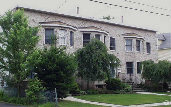
About 23-27 Burnside Ave Cranford, NJ 07016
At 23-27 Burnside Ave in Cranford, find a great place to live. These apartments are located at 23-27 Burnside Ave in Cranford. Make sure you to view the available floorplans. The community staff is ready to help match you with your new place. Drop by to talk about your next apartment.
23-27 Burnside Ave is an apartment community located in Union County and the 07016 ZIP Code. This area is served by the Cranford Public attendance zone.
Location
Get Directions
Cranford is a peaceful suburb situated in the heart of Union County. Lush with township and county parks as well as the Rahway River Parkway, Cranford offers ample opportunities to engage in outdoor recreation and connect with nature. Cranford is also home to the last working farm in Union County, Dreyer Farms, which provides fresh produce in addition to hosting a variety of special events.
Cranford’s vibrant downtown area contains a slew of restaurants, specialty shops, cafes, and art galleries in colorful buildings, serving as a gathering place for the close-knit community. Commuting and traveling from Cranford is easy with access to the NJ Transit bus, Raritan Valley train line, and the Garden State Parkway. New York City and its many dynamic amenities are less than an hour’s drive or train ride away from Cranford.
Learn more about living in Cranford
Education
| Colleges & Universities | Distance | ||
|---|---|---|---|
| Colleges & Universities | Distance | ||
| Drive: | 8 min | 2.3 mi | |
| Drive: | 13 min | 5.6 mi | |
| Drive: | 14 min | 6.8 mi | |
| Drive: | 17 min | 7.1 mi |
23-27 Burnside Ave is within 8 minutes or 2.3 miles from Union County College, Cranford. It is also near Kean University and Union County Coll., Elizabeth.
Schools


Public Elementary & Middle School
Grades PK-8
357 Students
Nearby
Public Elementary School
Grades PK-2
294 Students
Attendance Zone
Public Elementary School
Grades 3-5
253 Students
Attendance Zone
Public High School
Grades 9-12
1,095 Students
Attendance Zone
Private Elementary & Middle School
Grades PK-9
81 Students
Nearby
Private Elementary & Middle School
Grades PK-8
234 Students
Nearby
School data provided by
 The GreatSchools Rating helps parents compare schools within a state based on a variety of school quality indicators and provides a helpful picture of how effectively each school serves all of its students. Ratings are on a scale of 1 (below average) to 10 (above average) and can include test scores, college readiness, academic progress, advanced courses, equity, discipline and attendance data. We also advise parents to visit schools, consider other information on school performance and programs, and consider family needs as part of the school selection process.
View GreatSchools Rating Methodology
Data provided by GreatSchools.org © 2025. All rights reserved.
View GreatSchools Rating Methodology
Data provided by GreatSchools.org © 2025. All rights reserved.
Transportation options available in Cranford include Warren Street, located 10.6 miles from 23-27 Burnside Ave. 23-27 Burnside Ave is near Newark Liberty International, located 12.3 miles or 18 minutes away, and LaGuardia, located 31.6 miles or 52 minutes away.
| Transit / Subway | Distance | ||
|---|---|---|---|
| Transit / Subway | Distance | ||
|
|
Drive: | 18 min | 10.6 mi |
|
|
Drive: | 18 min | 10.7 mi |
|
|
Drive: | 18 min | 10.8 mi |
|
|
Drive: | 18 min | 11.1 mi |
|
|
Drive: | 18 min | 11.4 mi |
| Commuter Rail | Distance | ||
|---|---|---|---|
| Commuter Rail | Distance | ||
|
|
Walk: | 12 min | 0.6 mi |
|
|
Walk: | 14 min | 0.8 mi |
|
|
Drive: | 5 min | 2.0 mi |
|
|
Drive: | 9 min | 3.3 mi |
|
|
Drive: | 10 min | 4.7 mi |
| Airports | Distance | ||
|---|---|---|---|
| Airports | Distance | ||
|
Newark Liberty International
|
Drive: | 18 min | 12.3 mi |
|
LaGuardia
|
Drive: | 52 min | 31.6 mi |
Time and distance from 23-27 Burnside Ave.
| Shopping Centers | Distance | ||
|---|---|---|---|
| Shopping Centers | Distance | ||
| Walk: | 4 min | 0.2 mi | |
| Walk: | 8 min | 0.4 mi | |
| Walk: | 11 min | 0.6 mi |
23-27 Burnside Ave has 3 shopping centers within 0.6 mile, which is about a 11-minute walk. The miles and minutes will be for the farthest away property.
| Parks and Recreation | Distance | ||
|---|---|---|---|
| Parks and Recreation | Distance | ||
|
William Miller Sperry Observatory
|
Drive: | 6 min | 2.1 mi |
|
Trailside Museum Watchung Reservation
|
Drive: | 13 min | 4.6 mi |
|
Hawk Rise Sanctuary
|
Drive: | 15 min | 5.8 mi |
|
Cora Hartshorn Arboretum
|
Drive: | 19 min | 7.6 mi |
|
Merrill Park
|
Drive: | 16 min | 8.9 mi |
23-27 Burnside Ave has 5 parks within 8.9 miles, including William Miller Sperry Observatory, Trailside Museum Watchung Reservation, and Hawk Rise Sanctuary.
| Hospitals | Distance | ||
|---|---|---|---|
| Hospitals | Distance | ||
| Drive: | 10 min | 3.5 mi | |
| Drive: | 14 min | 5.9 mi | |
| Drive: | 17 min | 7.6 mi |
23-27 Burnside Ave has 3 hospitals within 7.6 miles, the nearest is Robert Wood Johnson University Hospital at Rahway which is 3.5 miles away and a 10 minute drive.
| Military Bases | Distance | ||
|---|---|---|---|
| Military Bases | Distance | ||
| Drive: | 12 min | 3.3 mi | |
| Drive: | 12 min | 5.0 mi | |
| Drive: | 24 min | 16.2 mi |
23-27 Burnside Ave has 3 military bases within 16.2 miles, the nearest is Tamdques Reservation which is 3.3 miles away and a 12 minute drive.
You May Also Like
How do I access Social Services in New Jersey?
Statewide service is free, confidential, multilingual and always open. Three easy ways to reach Social Services in NJ: Dial 2-1-1; text your zip code to 898-211; or chat at https://www.nj211.org
Similar Rentals Nearby


What Are Walk Score®, Transit Score®, and Bike Score® Ratings?
Walk Score® measures the walkability of any address. Transit Score® measures access to public transit. Bike Score® measures the bikeability of any address.
What is a Sound Score Rating?
A Sound Score Rating aggregates noise caused by vehicle traffic, airplane traffic and local sources

23-27 Burnside Ave
Cranford, NJ 07016
Responded To This Review