
$2,700 / Month
229 St Paul St Unit 1
Brookline, MA 02446
Today
Favorites
617-670-1111
-
Bedrooms
1
-
Bathrooms
1
-
Square Feet
999 sq ft
-
Available
Available Sep 1
229 St Paul St Unit 1

Favorites
About This Home
Available Sep 1
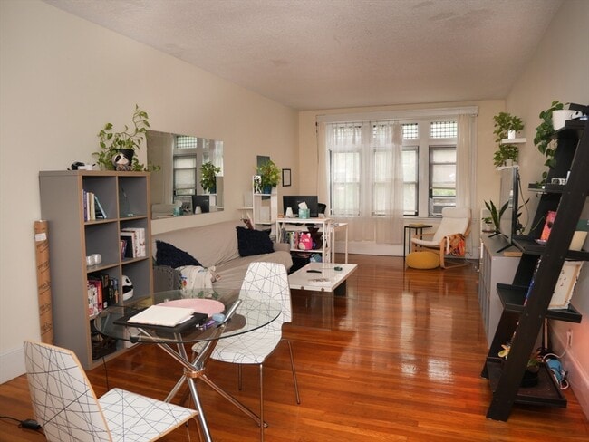
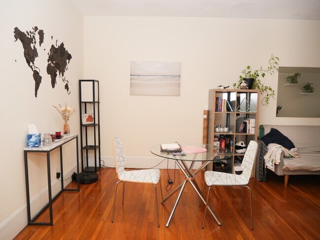
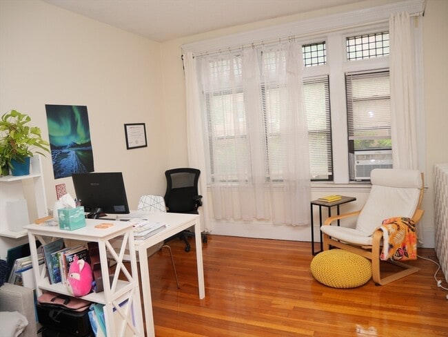
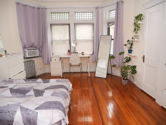
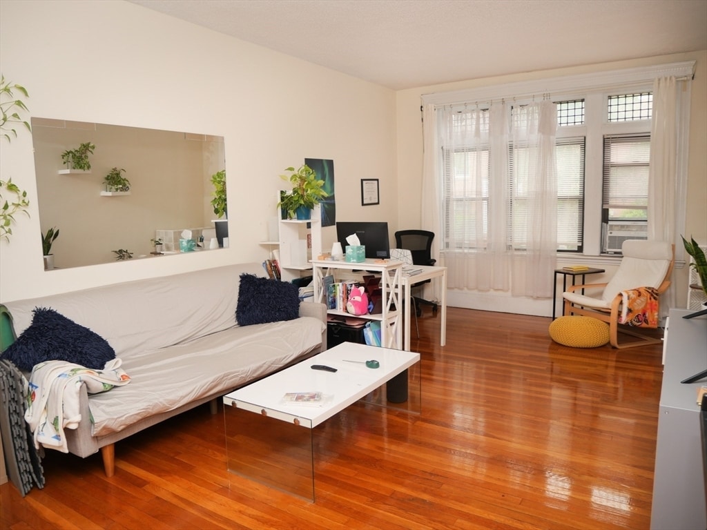
Spacious one bedroom apartment located in Brookline. Easy access public transportation,trader joes,pharmacies,restaurants,coffee shops,shopping,and much more. Short T-ride to Fenway park,Kenmore,Back bay,and Downtown Boston. Public garden and park right across the street. No pets,no undergraduates. Heat and hot water included in rent. Laundry in basement. First month and rental fee to move in. MLS# 73388729
229 St Paul St is an apartment community located in Norfolk County and the 02446 ZIP Code.
* Price shown is base rent and may not include non-optional fees and utilities.
Price, availability, fees, and any applicable rent special are subject to change without notice.
* Square footage definitions vary. Displayed square footage is approximate.
Home Details
Accessible Home Design
Entry on the 3rd floor
Bedrooms and Bathrooms
1 Full Bathroom
1 Bedroom
Home Design
Apartment
Interior Spaces
999 Sq Ft Home
Kitchen
Range
Dishwasher
Listing and Financial Details
Property Available on 9/1/25
Assessor Parcel Number 29504
Rent includes heat, hot water
Lot Details
999 Sq Ft Lot
Utilities
No Cooling
Community Details
Amenities
Laundry Facilities
Overview
No Home Owners Association
Pet Policy
No Pets Allowed
Fees and Policies
The fees below are based on community-supplied data and may exclude additional fees and utilities.
Contact
- Listed by Jason Gell | RE/MAX On the Charles
- Phone Number
-
Source
 MLS Property Information Network
The property listing data and information set forth herein were provided to MLS Property Information Network, Inc. from third party sources, including sellers, lessors and public records, and were compiled by MLS Property Information Network, Inc. The property listing data and information are for the personal, non-commercial use of consumers having a good faith interest in purchasing or leasing listed properties of the type displayed to them and may not be used for any purpose other than to identify prospective properties which such consumers may have a good faith interest in purchasing or leasing. MLS Property Information Network, Inc. and its subscribers disclaim any and all representations and warranties as to the accuracy of the property listing data and information set forth herein. All properties are subject to prior sale, change or withdrawal. Copyright © 2025 MLS Property Information Network, Inc. All rights reserved.
Location
Get Directions
Amenities
- Dishwasher
- Range
- Refrigerator
Located just four miles west of Downtown Boston, Coolidge Corner is a vibrant commercial hub brimming with activity and gorgeous historical buildings. Residents enjoy a large selection of shops, bookstores, restaurants, and coffee houses in Coolidge Corner as well as access to the landmark Coolidge Theatre, an Art Deco-inspired venue showcasing the best of contemporary art house and independent film.
Coolidge Corner exudes a nostalgic charm, and has attracted shoppers for more than 150 years. There’s a healthy mix of local businesses and familiar chains in Coolidge Corner, offering residents the best of both worlds. Home to its own T stop, Coolidge Corner is an ideal spot for commuters and college students alike.
Learn more about living in Coolidge Corner
Education
| Colleges & Universities | Distance | ||
|---|---|---|---|
| Colleges & Universities | Distance | ||
| Walk: | 13 min | 0.7 mi | |
| Walk: | 18 min | 1.0 mi | |
| Drive: | 3 min | 1.2 mi | |
| Drive: | 3 min | 1.2 mi |
229 St Paul St Unit 1 is within 13 minutes or 0.7 mile from Boston University. It is also near Lesley Univ., Art Institute and Simmons College.
Transportation options available in Brookline include Kent Street, located 0.2 mile from 229 St Paul St Unit 1. 229 St Paul St Unit 1 is near General Edward Lawrence Logan International, located 7.0 miles or 15 minutes away.
| Transit / Subway | Distance | ||
|---|---|---|---|
| Transit / Subway | Distance | ||
| Walk: | 3 min | 0.2 mi | |
| Walk: | 4 min | 0.2 mi | |
| Walk: | 6 min | 0.3 mi | |
| Walk: | 8 min | 0.4 mi | |
| Drive: | 3 min | 1.1 mi |
| Commuter Rail | Distance | ||
|---|---|---|---|
| Commuter Rail | Distance | ||
|
|
Drive: | 4 min | 2.0 mi |
|
|
Drive: | 9 min | 2.7 mi |
| Drive: | 7 min | 3.3 mi | |
| Drive: | 7 min | 3.5 mi | |
| Drive: | 13 min | 6.2 mi |
| Airports | Distance | ||
|---|---|---|---|
| Airports | Distance | ||
|
General Edward Lawrence Logan International
|
Drive: | 15 min | 7.0 mi |
Time and distance from 229 St Paul St Unit 1.
| Shopping Centers | Distance | ||
|---|---|---|---|
| Shopping Centers | Distance | ||
| Walk: | 14 min | 0.8 mi | |
| Walk: | 14 min | 0.8 mi | |
| Drive: | 4 min | 1.5 mi |
229 St Paul St Unit 1 has 3 shopping centers within 1.5 miles, which is about a 4-minute walk. The miles and minutes will be for the farthest away property.
| Parks and Recreation | Distance | ||
|---|---|---|---|
| Parks and Recreation | Distance | ||
|
John Fitzgerald Kennedy National Historic Site
|
Walk: | 12 min | 0.7 mi |
|
Coit Observatory
|
Drive: | 3 min | 1.2 mi |
|
Frederick Law Olmsted National Historic Site
|
Drive: | 5 min | 1.8 mi |
|
Charles River Reservation
|
Drive: | 4 min | 2.1 mi |
|
Roxbury Heritage State Park
|
Drive: | 6 min | 2.2 mi |
229 St Paul St Unit 1 has 5 parks within 2.2 miles, including John Fitzgerald Kennedy National Historic Site, Coit Observatory, and Charles River Reservation.
| Hospitals | Distance | ||
|---|---|---|---|
| Hospitals | Distance | ||
| Walk: | 10 min | 0.6 mi | |
| Walk: | 16 min | 0.8 mi | |
| Walk: | 17 min | 0.9 mi |
229 St Paul St Unit 1 has 3 hospitals within 0.9 mile, the nearest is Arbour Human Resource Institute which is 0.6 mile away and a 10 minute walk.
| Military Bases | Distance | ||
|---|---|---|---|
| Military Bases | Distance | ||
| Drive: | 28 min | 14.6 mi | |
| Drive: | 25 min | 14.7 mi |
229 St Paul St Unit 1 is 14.6 miles from Hanscom Air Force Base, and is convenient to other military bases, including US Military Reservation.
You May Also Like
Similar Rentals Nearby


What Are Walk Score®, Transit Score®, and Bike Score® Ratings?
Walk Score® measures the walkability of any address. Transit Score® measures access to public transit. Bike Score® measures the bikeability of any address.
What is a Sound Score Rating?
A Sound Score Rating aggregates noise caused by vehicle traffic, airplane traffic and local sources
229 St Paul St
Brookline, MA 02446