
$2,399 / Month
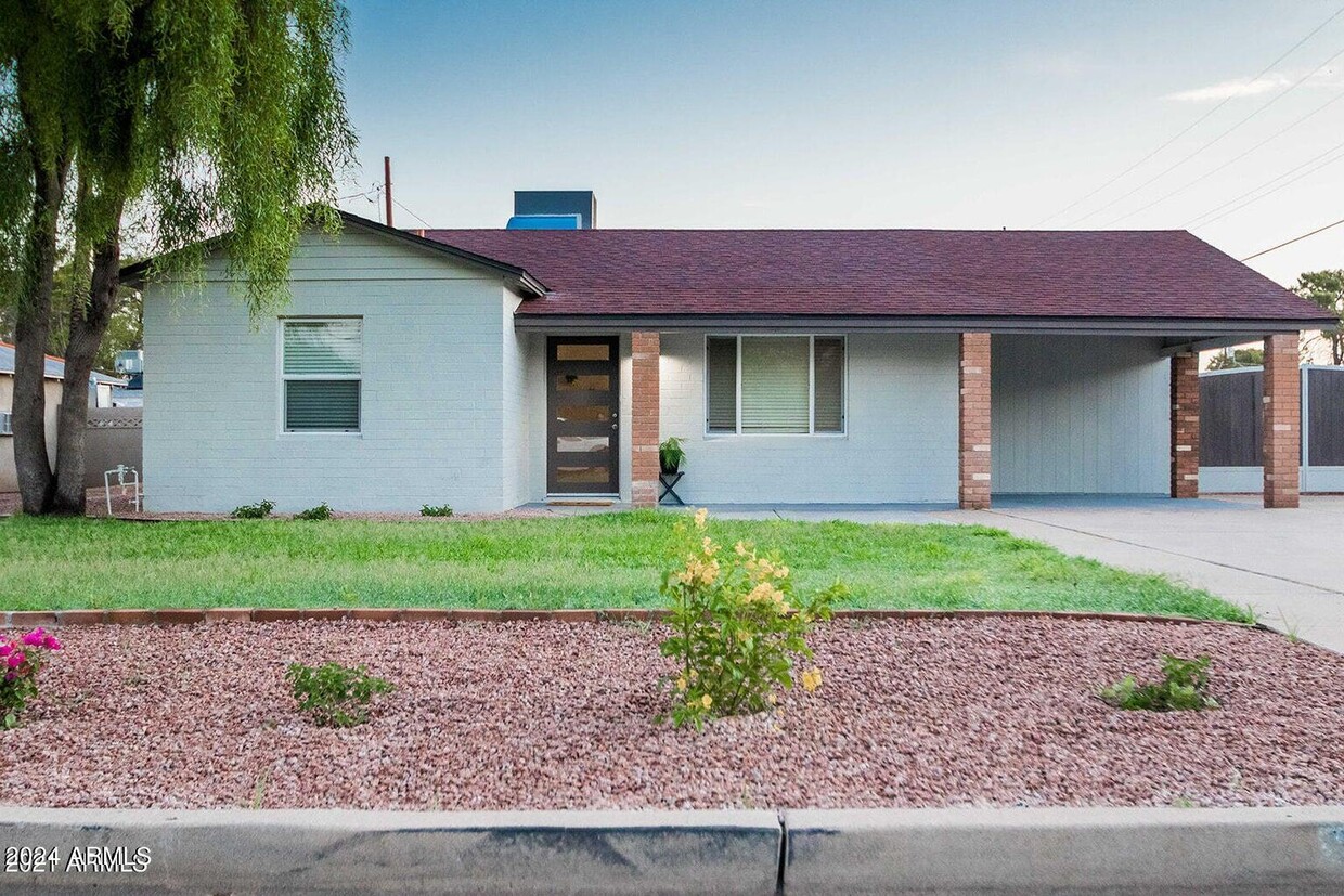
2244 E Monterey Way
Phoenix, AZ 85016
2 Weeks Ago
Favorites
2244 E Monterey Way

Favorites
Check Back Soon for Upcoming Availability
| Beds | Baths | Average SF |
|---|---|---|
| 3 Bedrooms 3 Bedrooms 3 Br | 2 Baths 2 Baths 2 Ba | 1,121 SF |
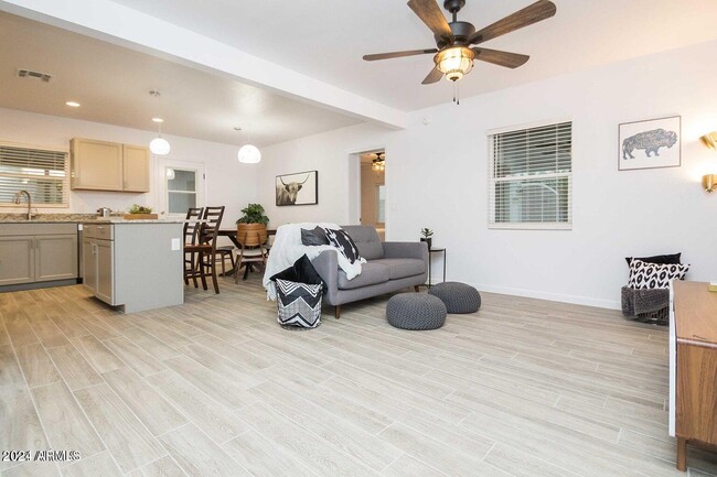
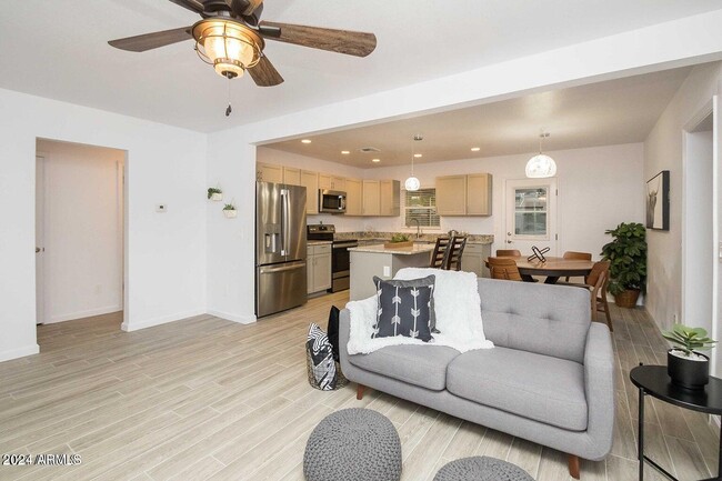
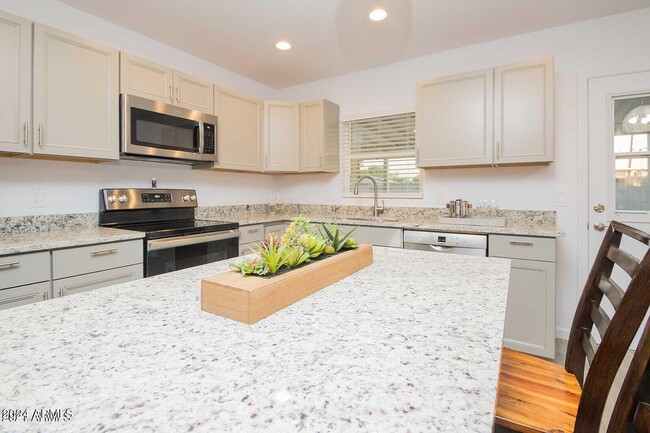
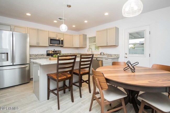
About This Property
This home meets those MUST-HAVES for a home rental. It's a 3 bedroom,2 bath,single level,fully remodeled. LOCATION! This home is located in an established neighborhood in the Biltmore area with easy freeway access. Close to the Phoenix Children's Hospital,Banner University Medical Center and the Biltmore Fashion Park with tons of great restaurants and shops. This home features an open floor plan,wood-plank tile throughout,patio with extended pavers,and easy maintenance private backyard. Landscape maintenance is included in the rent. Tenant pays 2.3% city tax.
2244 E Monterey Way is a house located in Maricopa County and the 85016 ZIP Code. This area is served by the Creighton Elementary District attendance zone.
Location
Get Directions
With its lush, garden-like landscaping and premier shopping centers, Biltmore is considered by many to be one of Phoenix’s most acclaimed residential communities. The neighborhood is home to the Arizona Biltmore Hotel, a resort with incredible golfing and innovative culinary restaurants, surrounded by the city’s most upscale homes.
Biltmore is at the heart of the Financial District – so you bet there will be modern office spaces, high-rise apartments, and luxury boutiques everywhere you turn. Biltmore Fashion Park is located at the intersection of 24th Street and Camelback Road. This open-air shopping plaza features brands like Ralph Lauren, Stuart Weitzman, and Jonathan Adler among numerous white-glove service restaurants.
Adjacent to the mall is the Camby Hotel’s award-winning restaurant Artizen – which is run by Chef Dushryant Singh, a “Best Upcoming Chef” nominee by Arizona Culinary Hall of Fame.
Learn more about living in BiltmoreBelow are rent ranges for similar nearby apartments
| Beds | Average Size | Lowest | Typical | Premium |
|---|---|---|---|---|
| Studio Studio Studio | 457-460 Sq Ft | $522 | $1,233 | $3,684 |
| 1 Bed 1 Bed 1 Bed | 718-719 Sq Ft | $822 | $1,606 | $4,009 |
| 2 Beds 2 Beds 2 Beds | 1113-1114 Sq Ft | $999 | $2,261 | $20,000 |
| 3 Beds 3 Beds 3 Beds | 1745 Sq Ft | $1,700 | $3,711 | $15,000 |
| 4 Beds 4 Beds 4 Beds | 2345 Sq Ft | $1,885 | $5,904 | $25,000 |
Education
| Colleges & Universities | Distance | ||
|---|---|---|---|
| Colleges & Universities | Distance | ||
| Drive: | 8 min | 3.6 mi | |
| Drive: | 8 min | 4.3 mi | |
| Drive: | 9 min | 4.5 mi | |
| Drive: | 9 min | 4.6 mi |
2244 E Monterey Way is within 8 minutes or 3.6 miles from Phoenix College. It is also near Gateway Community College and University of Arizona.
Schools


Public Elementary & Middle School
Grades PK-8
477 Students
Attendance Zone
Public High School
Grades 9-12
2,238 Students
Attendance Zone
Private Elementary & Middle School
Grades PK-8
141 Students
Nearby
Private Elementary & Middle School
Grades PK-9
Nearby
Private Elementary, Middle & High School
Grades 2-12
Nearby
School data provided by
 The GreatSchools Rating helps parents compare schools within a state based on a variety of school quality indicators and provides a helpful picture of how effectively each school serves all of its students. Ratings are on a scale of 1 (below average) to 10 (above average) and can include test scores, college readiness, academic progress, advanced courses, equity, discipline and attendance data. We also advise parents to visit schools, consider other information on school performance and programs, and consider family needs as part of the school selection process.
View GreatSchools Rating Methodology
Data provided by GreatSchools.org © 2025. All rights reserved.
View GreatSchools Rating Methodology
Data provided by GreatSchools.org © 2025. All rights reserved.
Transportation options available in Phoenix include Osborn/Central Ave, located 2.7 miles from 2244 E Monterey Way. 2244 E Monterey Way is near Phoenix Sky Harbor International, located 6.3 miles or 12 minutes away, and Phoenix-Mesa Gateway, located 33.1 miles or 44 minutes away.
| Transit / Subway | Distance | ||
|---|---|---|---|
| Transit / Subway | Distance | ||
|
|
Drive: | 6 min | 2.7 mi |
|
|
Drive: | 6 min | 3.0 mi |
|
|
Drive: | 7 min | 3.1 mi |
|
|
Drive: | 7 min | 3.4 mi |
|
|
Drive: | 8 min | 3.5 mi |
| Commuter Rail | Distance | ||
|---|---|---|---|
| Commuter Rail | Distance | ||
|
|
Drive: | 44 min | 34.2 mi |
| Airports | Distance | ||
|---|---|---|---|
| Airports | Distance | ||
|
Phoenix Sky Harbor International
|
Drive: | 12 min | 6.3 mi |
|
Phoenix-Mesa Gateway
|
Drive: | 44 min | 33.1 mi |
Time and distance from 2244 E Monterey Way.
| Shopping Centers | Distance | ||
|---|---|---|---|
| Shopping Centers | Distance | ||
| Walk: | 6 min | 0.3 mi | |
| Walk: | 11 min | 0.6 mi | |
| Walk: | 13 min | 0.7 mi |
2244 E Monterey Way has 3 shopping centers within 0.7 mile, which is about a 13-minute walk. The miles and minutes will be for the farthest away property.
| Parks and Recreation | Distance | ||
|---|---|---|---|
| Parks and Recreation | Distance | ||
|
Steele Indian School Park
|
Drive: | 6 min | 2.9 mi |
|
Tonto National Forest
|
Drive: | 6 min | 3.3 mi |
|
Eastlake Park
|
Drive: | 7 min | 4.0 mi |
|
Margaret T. Hance Park
|
Drive: | 6 min | 4.3 mi |
|
Desert Storm Park
|
Drive: | 8 min | 4.3 mi |
2244 E Monterey Way has 5 parks within 4.3 miles, including Steele Indian School Park, Desert Storm Park, and Tonto National Forest.
| Hospitals | Distance | ||
|---|---|---|---|
| Hospitals | Distance | ||
| Drive: | 2 min | 1.1 mi | |
| Drive: | 3 min | 1.7 mi | |
| Drive: | 4 min | 2.2 mi |
2244 E Monterey Way has 3 hospitals within 2.2 miles, the nearest is Phoenix Children's Hospital which is 1.1 miles away and a 2 minute drive.
| Military Bases | Distance | ||
|---|---|---|---|
| Military Bases | Distance | ||
| Drive: | 13 min | 6.2 mi | |
| Drive: | 34 min | 25.2 mi | |
| Drive: | 102 min | 77.7 mi |
2244 E Monterey Way has 3 military bases within 77.7 miles, the nearest is Phoenix Sky Harbor Airport Air Guard Station which is 6.2 miles away and a 13 minute drive.
You May Also Like
Similar Rentals Nearby
-
-
-
-
-
-
1 / 23

-
-
1 / 51

-
-


What Are Walk Score®, Transit Score®, and Bike Score® Ratings?
Walk Score® measures the walkability of any address. Transit Score® measures access to public transit. Bike Score® measures the bikeability of any address.
What is a Sound Score Rating?
A Sound Score Rating aggregates noise caused by vehicle traffic, airplane traffic and local sources
2244 E Monterey Way
Phoenix, AZ 85016