1 / 23


| Beds | Baths | Average SF |
|---|---|---|
| 1 Bedroom 1 Bedroom 1 Br | 1 Bath 1 Bath 1 Ba | — |
The fees below are based on community-supplied data and may exclude additional fees and utilities.
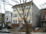
Located just two miles outside of Downtown Newark, Upper Clinton Hill is a popular neighborhood in the city. Historic architecture and proximity to three major universities — the New Jersey Institute of Technology, Rutgers University-Newark, and Seton Hall University — combined with its easy access to medical centers, the Newark Liberty International Airport, the port, and Interstate 78 make Upper Clinton stand out. The neighborhood also sits less than 20 miles southwest of Manhattan. While Upper Clinton Hill is a primarily residential area, there are a few shops, restaurants, and businesses scattered throughout the neighborhood. This walkable community offers unique apartments, houses, condos, and townhomes available for rent ranging from affordable to upscale.
Learn more about living in Upper Clinton Hill| Colleges & Universities | Distance | ||
|---|---|---|---|
| Colleges & Universities | Distance | ||
| Drive: | 5 min | 2.6 mi | |
| Drive: | 6 min | 2.7 mi | |
| Drive: | 6 min | 3.0 mi | |
| Drive: | 10 min | 4.4 mi |
Transportation options available in Newark include Warren Street, located 2.6 miles from 222 W Runyon St. 222 W Runyon St is near Newark Liberty International, located 4.6 miles or 7 minutes away, and LaGuardia, located 23.9 miles or 41 minutes away.
| Transit / Subway | Distance | ||
|---|---|---|---|
| Transit / Subway | Distance | ||
|
|
Drive: | 5 min | 2.6 mi |
|
|
Drive: | 5 min | 2.6 mi |
|
|
Drive: | 5 min | 2.6 mi |
|
|
Drive: | 5 min | 2.8 mi |
|
|
Drive: | 6 min | 2.8 mi |
| Commuter Rail | Distance | ||
|---|---|---|---|
| Commuter Rail | Distance | ||
|
|
Drive: | 8 min | 2.8 mi |
|
|
Drive: | 8 min | 2.8 mi |
|
|
Drive: | 6 min | 3.1 mi |
|
|
Drive: | 7 min | 3.3 mi |
|
|
Drive: | 10 min | 3.6 mi |
| Airports | Distance | ||
|---|---|---|---|
| Airports | Distance | ||
|
Newark Liberty International
|
Drive: | 7 min | 4.6 mi |
|
LaGuardia
|
Drive: | 41 min | 23.9 mi |
Time and distance from 222 W Runyon St.
| Shopping Centers | Distance | ||
|---|---|---|---|
| Shopping Centers | Distance | ||
| Drive: | 3 min | 1.1 mi | |
| Drive: | 3 min | 1.3 mi | |
| Drive: | 3 min | 1.5 mi |
| Parks and Recreation | Distance | ||
|---|---|---|---|
| Parks and Recreation | Distance | ||
|
Newark Museum and Dreyfuss Planetarium
|
Drive: | 5 min | 2.9 mi |
|
Branch Brook Park
|
Drive: | 9 min | 4.4 mi |
|
Kearny Marsh
|
Drive: | 13 min | 6.0 mi |
|
Edison National Historic Site
|
Drive: | 13 min | 6.6 mi |
|
Turtle Back Zoo
|
Drive: | 17 min | 8.6 mi |
| Hospitals | Distance | ||
|---|---|---|---|
| Hospitals | Distance | ||
| Walk: | 16 min | 0.8 mi | |
| Drive: | 3 min | 1.9 mi | |
| Drive: | 6 min | 3.0 mi |
| Military Bases | Distance | ||
|---|---|---|---|
| Military Bases | Distance | ||
| Drive: | 12 min | 8.4 mi | |
| Drive: | 24 min | 12.6 mi | |
| Drive: | 29 min | 16.4 mi |
222 W Runyon St Newark, NJ 07108 has one bedroom available with rent ranges from /mo. to /mo.
Yes, to view the floor plan in person, please schedule a personal tour.
222 W Runyon St Newark, NJ 07108 is in Upper Clinton Hill in the city of Newark. Here you’ll find three shopping centers within 1.5 miles of the property. Five parks are within 8.6 miles, including Newark Museum and Dreyfuss Planetarium, Branch Brook Park, and Kearny Marsh.
Statewide service is free, confidential, multilingual and always open. Three easy ways to reach Social Services in NJ: Dial 2-1-1; text your zip code to 898-211; or chat at https://www.nj211.org
What Are Walk Score®, Transit Score®, and Bike Score® Ratings?
Walk Score® measures the walkability of any address. Transit Score® measures access to public transit. Bike Score® measures the bikeability of any address.
What is a Sound Score Rating?
A Sound Score Rating aggregates noise caused by vehicle traffic, airplane traffic and local sources

222 W Runyon St
Newark, NJ 07108


