$3,200 / Month
22 Personette St Unit 1
Cedar Grove, NJ 07009
2 Weeks Ago
Favorites
22 Personette St Unit 1

Favorites
Check Back Soon for Upcoming Availability
| Beds | Baths | Average SF |
|---|---|---|
| 3 Bedrooms 3 Bedrooms 3 Br | 1 Bath 1 Bath 1 Ba | — |
Fees and Policies
The fees below are based on community-supplied data and may exclude additional fees and utilities.
About This Property
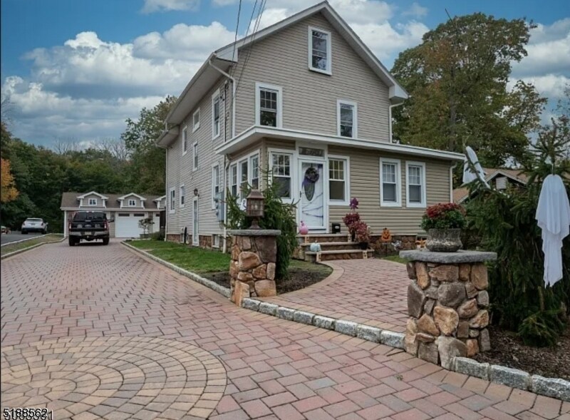
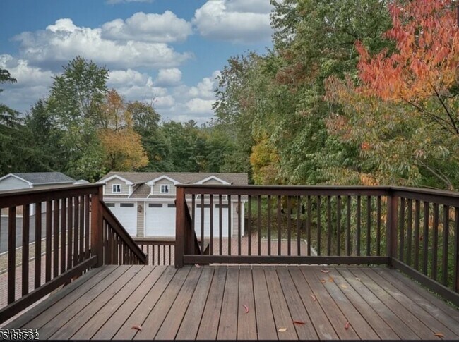
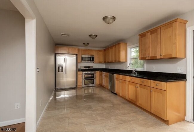
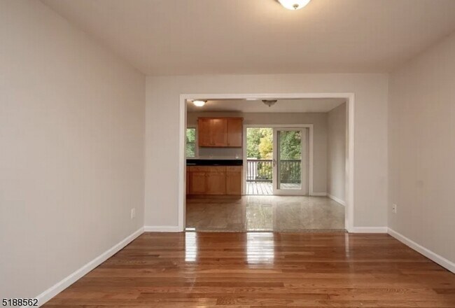
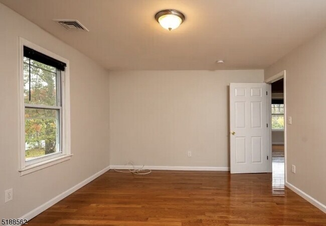
GREAT 2ND & 3RD FLOOR RENTAL IN MULTIFAMILY. EVERYTHING WAS RENOVATED 6 YEARS AGO. NEW LIVING RM., KITCHEN W/GRANITE COUNTERTOPS & NEW APPLIANCES. KITCHEN AREA LEADS TO BEAUTIFUL DECK. 2 ASSIGNED PARKING SPACES INCLUDED IN RENT. 2 BEDROOMS & BATH ON SECOND FLOOR & 3RD BEDROOM/FAMILY ROOM ON 3RD FL. WASHER & DRYER IN UNIT. TENANT PAYS OWN GAS, HEAT & ELECTRICITY. TENANT RESPONSIBLE FOR PSE&G MAINTENANCE OF CONTRACT FOR APPLIANCES. HOUSE HAS WATER PURIFIER. TENANT RESPONSIBLE FOR SNOW REMOVAL OF DRIVEWAY TO BE SHARED WITH FIRST FLOOR TENANT AND BACK DECK AND STAIRS.
22 Personette St is an apartment community located in Essex County and the 07009 ZIP Code.
Features
- Tile Floors
- Deck
Location
Get Directions
Located about 20 miles northwest of New York City, Cedar Grove provides residents with a tranquil small-town atmosphere in Essex County. Pompton Avenue is Cedar Grove’s main commercial thoroughfare, where a bevy of quaint shops and diverse restaurants sit along a tree-lined street.
Several parks offer plenty of options for outdoor recreation in Cedar Grove, including the expansive Mills Reservation County Park, Hilltop Reservation, and Cedar Grove Community Park. Cedar Grove is also within minutes of Verona Park, Eagle Rock Reservation, and Brookdale Park. Quick access to numerous NJ Transit rail stations and major highways affords residents easy commutes and travels from Cedar Grove.
Learn more about living in Cedar Grove
Amenities
- Tile Floors
- Deck
Education
| Colleges & Universities | Distance | ||
|---|---|---|---|
| Colleges & Universities | Distance | ||
| Drive: | 7 min | 3.5 mi | |
| Drive: | 9 min | 4.1 mi | |
| Drive: | 10 min | 5.5 mi | |
| Drive: | 10 min | 5.5 mi |
22 Personette St Unit 1 is within 7 minutes or 3.5 miles from Montclair State University. It is also near Caldwell College and Berkeley College.
Transportation options available in Cedar Grove include Grove Street, located 6.7 miles from 22 Personette St Unit 1. 22 Personette St Unit 1 is near Newark Liberty International, located 15.2 miles or 26 minutes away, and LaGuardia, located 30.8 miles or 44 minutes away.
| Transit / Subway | Distance | ||
|---|---|---|---|
| Transit / Subway | Distance | ||
|
|
Drive: | 12 min | 6.7 mi |
|
|
Drive: | 13 min | 7.1 mi |
|
|
Drive: | 13 min | 7.2 mi |
|
|
Drive: | 14 min | 7.3 mi |
|
|
Drive: | 13 min | 7.6 mi |
| Commuter Rail | Distance | ||
|---|---|---|---|
| Commuter Rail | Distance | ||
|
|
Drive: | 3 min | 1.9 mi |
|
|
Drive: | 6 min | 2.5 mi |
|
|
Drive: | 6 min | 2.7 mi |
|
|
Drive: | 6 min | 2.8 mi |
|
|
Drive: | 7 min | 3.8 mi |
| Airports | Distance | ||
|---|---|---|---|
| Airports | Distance | ||
|
Newark Liberty International
|
Drive: | 26 min | 15.2 mi |
|
LaGuardia
|
Drive: | 44 min | 30.8 mi |
Time and distance from 22 Personette St Unit 1.
| Shopping Centers | Distance | ||
|---|---|---|---|
| Shopping Centers | Distance | ||
| Walk: | 11 min | 0.6 mi | |
| Walk: | 17 min | 0.9 mi | |
| Walk: | 21 min | 1.1 mi |
22 Personette St Unit 1 has 3 shopping centers within 1.1 miles, which is about a 21-minute walk. The miles and minutes will be for the farthest away property.
| Parks and Recreation | Distance | ||
|---|---|---|---|
| Parks and Recreation | Distance | ||
|
Presby Memorial Iris Gardens
|
Drive: | 6 min | 2.7 mi |
|
Van Vleck House & Gardens
|
Drive: | 6 min | 3.3 mi |
|
Edison National Historic Site
|
Drive: | 14 min | 7.1 mi |
|
Fairfield Farm
|
Drive: | 13 min | 7.2 mi |
|
NJ Audubon Essex County Environmental Center
|
Drive: | 14 min | 8.2 mi |
22 Personette St Unit 1 has 5 parks within 8.2 miles, including Presby Memorial Iris Gardens, Van Vleck House & Gardens, and Edison National Historic Site.
| Hospitals | Distance | ||
|---|---|---|---|
| Hospitals | Distance | ||
| Walk: | 16 min | 0.9 mi | |
| Drive: | 11 min | 7.1 mi | |
| Drive: | 13 min | 7.7 mi |
22 Personette St Unit 1 has 3 hospitals within 7.7 miles, the nearest is Essex County Hospital Center which is 0.9 mile away and a 16 minute walk.
| Military Bases | Distance | ||
|---|---|---|---|
| Military Bases | Distance | ||
| Drive: | 31 min | 19.1 mi | |
| Drive: | 38 min | 21.8 mi | |
| Drive: | 36 min | 23.5 mi |
22 Personette St Unit 1 has 3 military bases within 23.5 miles, the nearest is Military Ocean Terminal which is 19.1 miles away and a 31 minute drive.
You May Also Like
Similar Rentals Nearby


What Are Walk Score®, Transit Score®, and Bike Score® Ratings?
Walk Score® measures the walkability of any address. Transit Score® measures access to public transit. Bike Score® measures the bikeability of any address.
What is a Sound Score Rating?
A Sound Score Rating aggregates noise caused by vehicle traffic, airplane traffic and local sources

22 Personette St
Cedar Grove, NJ 07009