$2,600 / Month
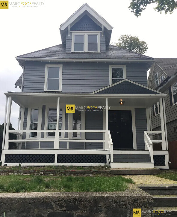
22 Mansfield St
Boston, MA 02134
2 Weeks Ago
Favorites
-
Bedrooms
1
-
Bathrooms
1
-
Square Feet
9,999 sq ft
-
Available
Available Now
22 Mansfield St

Favorites
About This Home
12 Month Lease,
$2,600 deposit,
Available Now
Excelente ubicación en el atractivo Lower Allston, un excelente vecindario apartado de los caminos trillados, pero conveniente para toda la emoción de Boston. Cerca de bares y restaurantes locales, Packard's Corner, Kenmore Square, Fenway y con fácil acceso a toda la ciudad con el tren Green Line B cercano y múltiples rutas de autobús importantes de MBTA. Un viaje fácil a Boston University, Boston College, Harvard Business School, Northeastern, Simmons, Berklee, Emmanuel, Wheelock, Mass College of Pharmacy, NE Conservatory, Mass College of Art, Wentworth, Boston Architectural College, Longwood Medical Area y mucho más.
22 Mansfield St is a condo located in Suffolk County and the 02134 ZIP Code. This area is served by the Boston Public Schools attendance zone.
* Price shown is base rent and may not include non-optional fees and utilities.
Price, availability, fees, and any applicable rent special are subject to change without notice.
* Square footage definitions vary. Displayed square footage is approximate.
Condo Features
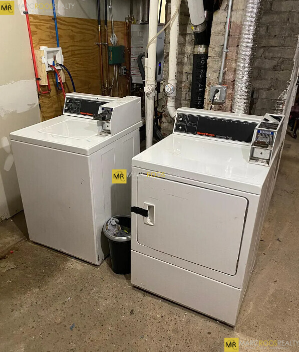
- Instalaciones de lavandería
- Senderos para caminar/montar en bicicleta
Fees and Policies
The fees below are based on community-supplied data and may exclude additional fees and utilities.
Details
Utilities Included
-
Water
-
Electricity
-
Heat
-
Sewer
Contact
- Listed by Sadie Milne
- Contact
Location
Get Directions
North Allston, also known as Lower Allston, is a peaceful neighborhood just five miles west of downtown Boston. This community is nestled along the Charles River and houses part of Harvard University, particularly Harvard Business School, Harvard Stadium, and the University’s other athletic fields.
In North Allston, you’ll find bike and pedestrian-friendly streets with an abundance of walking, biking, and jogging trails, community parks, and open green space overlooking the river. Enjoy delicious eats and drinks at Article 24, or try an old-school breakfast at a quaint corner diner known as the Breakfast Club. For the freshest baked goods in town, venture over to Swissbäkers on Western Avenue.
North Allston is a wonderful mix of student housing, upscale homes, and amenity-filled apartments and condos available for rent. Explore your options and find your ideal apartment in this quiet, affluent neighborhood near all of Boston’s major attractions.
Learn more about living in North Allston
Education
| Colleges & Universities | Distance | ||
|---|---|---|---|
| Colleges & Universities | Distance | ||
| Drive: | 4 min | 1.3 mi | |
| Drive: | 4 min | 1.7 mi | |
| Drive: | 4 min | 2.0 mi | |
| Drive: | 6 min | 2.1 mi |
22 Mansfield St is within 4 minutes or 1.3 miles from Harvard University. It is also near Cambridge College and Boston University.
Schools


Public Elementary & Middle School
Grades PK-8
386 Students
Attendance Zone
Public Middle & High School
Grades 7-12
532 Students
Attendance Zone
Public Middle & High School
Grades 7-12
2,423 Students
Attendance Zone
Charter Middle & High School
Grades 6-12
476 Students
Attendance Zone
Public High School
Grades 9-12
116 Students
Attendance Zone
Private Elementary, Middle & High School
Grades PK-12
281 Students
Nearby
Private Elementary & Middle School
Grades K-8
30 Students
Nearby
School data provided by
 The GreatSchools Rating helps parents compare schools within a state based on a variety of school quality indicators and provides a helpful picture of how effectively each school serves all of its students. Ratings are on a scale of 1 (below average) to 10 (above average) and can include test scores, college readiness, academic progress, advanced courses, equity, discipline and attendance data. We also advise parents to visit schools, consider other information on school performance and programs, and consider family needs as part of the school selection process.
View GreatSchools Rating Methodology
View GreatSchools Rating Methodology
Transportation options available in Boston include Harvard Avenue, located 0.6 mile from 22 Mansfield St. 22 Mansfield St is near General Edward Lawrence Logan International, located 7.9 miles or 14 minutes away.
| Transit / Subway | Distance | ||
|---|---|---|---|
| Transit / Subway | Distance | ||
|
|
Walk: | 12 min | 0.6 mi |
|
|
Walk: | 15 min | 0.8 mi |
|
|
Walk: | 15 min | 0.8 mi |
|
|
Drive: | 3 min | 1.2 mi |
|
|
Drive: | 4 min | 1.3 mi |
| Commuter Rail | Distance | ||
|---|---|---|---|
| Commuter Rail | Distance | ||
|
|
Drive: | 3 min | 2.0 mi |
|
|
Drive: | 6 min | 2.4 mi |
|
|
Drive: | 8 min | 3.5 mi |
|
|
Drive: | 9 min | 3.8 mi |
| Drive: | 11 min | 5.5 mi |
| Airports | Distance | ||
|---|---|---|---|
| Airports | Distance | ||
|
General Edward Lawrence Logan International
|
Drive: | 14 min | 7.9 mi |
Time and distance from 22 Mansfield St.
| Shopping Centers | Distance | ||
|---|---|---|---|
| Shopping Centers | Distance | ||
| Walk: | 10 min | 0.5 mi | |
| Drive: | 3 min | 1.1 mi | |
| Drive: | 4 min | 1.3 mi |
22 Mansfield St has 3 shopping centers within 1.3 miles, which is about a 4-minute walk. The miles and minutes will be for the farthest away property.
| Parks and Recreation | Distance | ||
|---|---|---|---|
| Parks and Recreation | Distance | ||
|
John Fitzgerald Kennedy National Historic Site
|
Drive: | 3 min | 1.4 mi |
|
Longfellow National Historic Site
|
Drive: | 5 min | 1.8 mi |
|
Harvard-Smithsonian Center for Astrophysics
|
Drive: | 7 min | 2.3 mi |
|
Coit Observatory
|
Drive: | 5 min | 2.4 mi |
|
Charles River Reservation
|
Drive: | 7 min | 3.4 mi |
22 Mansfield St has 5 parks within 3.4 miles, including John Fitzgerald Kennedy National Historic Site, Coit Observatory, and Longfellow National Historic Site.
| Hospitals | Distance | ||
|---|---|---|---|
| Hospitals | Distance | ||
| Drive: | 3 min | 1.3 mi | |
| Drive: | 3 min | 1.4 mi | |
| Drive: | 4 min | 1.5 mi |
22 Mansfield St has 3 hospitals within 1.5 miles, the nearest is Arbour Human Resource Institute which is 1.3 miles away and a 3 minute drive.
| Military Bases | Distance | ||
|---|---|---|---|
| Military Bases | Distance | ||
| Drive: | 25 min | 13.0 mi | |
| Drive: | 26 min | 15.2 mi |
22 Mansfield St is 13.0 miles from Hanscom Air Force Base, and is convenient to other military bases, including US Military Reservation.
Amenities
- Instalaciones de lavandería
- Senderos para caminar/montar en bicicleta
22 Mansfield St Photos
What Are Walk Score®, Transit Score®, and Bike Score® Ratings?
Walk Score® measures the walkability of any address. Transit Score® measures access to public transit. Bike Score® measures the bikeability of any address.
What is a Sound Score Rating?
A Sound Score Rating aggregates noise caused by vehicle traffic, airplane traffic and local sources

22 Mansfield St
Boston, MA 02134