$5,000
/ Month
2136 Tysons Ridgeline Rd
Pimmit Hills, VA 22043
Today
|
Edit
Favorites
301-523-8008
-
Bedrooms
3
-
Bathrooms
3.5
-
Square Feet
--
-
Available
Available Now
Highlights
- Built in 2024 | New Construction
- Contemporary Architecture
- 1 Fireplace
- 1 Car Attached Garage
- Tankless Water Heater
- Forced Air Heating and Cooling System
2136 Tysons Ridgeline Rd

Favorites
About This Home
Available Now
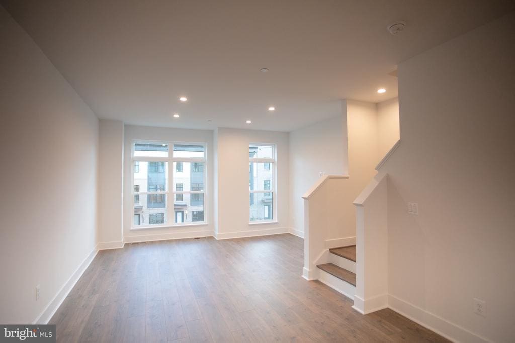
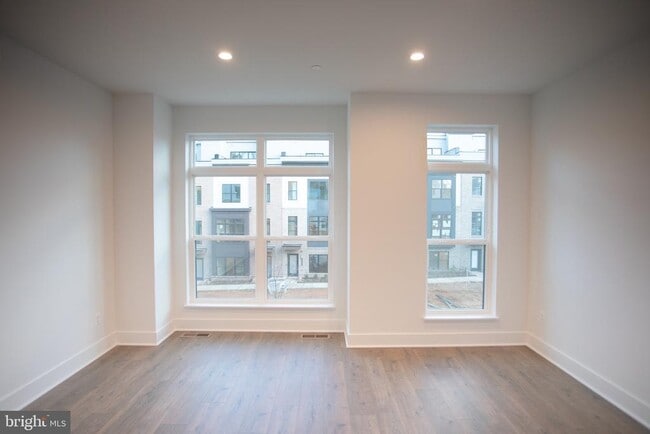
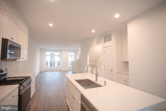
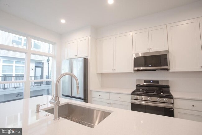
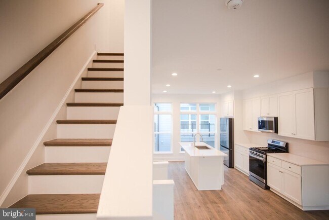
New luxury Townhome in sought-after Tysons Ridge new development, just minutes from Tyson Corner, Whole Foods, and Trader Joe's and easy access to IAD Airport. 3 bedroom suites. open floor plan. Large kitchen with island, stainless steel appliances, quatz countertops. 2-car garage......quiet community, facing beautiful garden, offering both convenience and tranquility.
Unique Features
- NewConstruction
2136 Tysons Ridgeline Rd is a townhome located in Fairfax County and the 22043 ZIP Code. This area is served by the Fairfax County Public Schools attendance zone.
* Price shown is base rent. Excludes user-selected optional fees and variable or usage-based fees and required charges due at or prior to move-in or at move-out. Price, availability, fees, and any applicable rent special are subject to change without notice.
* Square footage definitions vary. Displayed square footage is approximate.
Home Details
Home Type
Interior Unit Townhome
Year Built
Built in 2024 | New Construction
Bedrooms and Bathrooms
3.5 Bathrooms
3 Bedrooms
Home Design
Contemporary Architecture
Brick Exterior Construction
Vinyl Siding
Concrete Perimeter Foundation
Interior Spaces
1 Fireplace
1,636 Sq Ft Home
Property has 4 Levels
Listing and Financial Details
Security Deposit $5,000
24-Month Min and 48-Month Max Lease Term
Available 11/5/25
Assessor Parcel Number 0392 58 0090
Tenant pays for frozen waterpipe damage, internet, insurance, lawn/tree/shrub care, light bulbs/filters/fuses/alarm care, minor interior maintenance, snow removal, all utilities, windows/screens
Rent includes hoa/condo fee
No Smoking Allowed
Residential Lease
Lot Details
768 Sq Ft Lot
Property is in excellent condition
Parking
1 Car Attached Garage
Rear-Facing Garage
Garage Door Opener
Utilities
Tankless Water Heater
Forced Air Heating and Cooling System
Natural Gas Water Heater
Public Septic
Community Details
Pet Policy
No Pets Allowed
Contact
- Listed by Xuri Wang | Hometown Elite Realty LLC
- Phone Number
- Contact
-
Source
 Bright MLS, Inc.
Copyright © 2025 Bright MLS, Inc.
Location
Get Directions
Amenities
- Fireplace
- NewConstruction
Outstanding tacos and quality education may seem like an odd pair, but it sure does work for Pimmit Hills! Taco Bamba is a staple to living in Pimmit Hills with its quick and delicious tacos that are food truck style, so be sure to check it out after you find you perfect apartment. And don’t forget about the quality public schools in Fairfax County Public Schools, along with various high-ranking private schools.
This upscale neighborhood boasts a premier location just 13 miles west of Washington D.C. with various apartment rentals. The nation’s capital is at your fingertips when you live in this quaint neighborhood. You can visit the Smithsonian National Zoo, admire the Washington Monument, or even tour the White House! And if you’re interested in visiting other neighboring areas for work or play, this neighborhood is completely commuter-friendly, as it’s surrounded by major interstates.
Learn more about living in Pimmit Hills
Education
| Colleges & Universities | Distance | ||
|---|---|---|---|
| Colleges & Universities | Distance | ||
| Drive: | 14 min | 6.2 mi | |
| Drive: | 14 min | 7.2 mi | |
| Drive: | 14 min | 7.9 mi | |
| Drive: | 20 min | 9.5 mi |
2136 Tysons Ridgeline Rd is within 14 minutes or 6.2 miles from Marymount University. It is also near George Mason Univ., Arlington and NOVA, Annandale Campus.
Schools


Public Elementary School
Grades PK-6
584 Students
Attendance Zone
Public Middle School
Grades 7-8
1,148 Students
Attendance Zone
Public High School
Grades 9-12
2,109 Students
Attendance Zone
Private Elementary & Middle School
Grades K-8
Nearby
Private Elementary & Middle School
Grades PK-8
435 Students
Nearby
Private Middle & High School
Grades 6-12
Nearby
School data provided by
 The GreatSchools Rating helps parents compare schools within a state based on a variety of school quality indicators and provides a helpful picture of how effectively each school serves all of its students. Ratings are on a scale of 1 (below average) to 10 (above average) and can include test scores, college readiness, academic progress, advanced courses, equity, discipline and attendance data. We also advise parents to visit schools, consider other information on school performance and programs, and consider family needs as part of the school selection process.
View GreatSchools Rating Methodology
Data provided by GreatSchools.org © 2025. All rights reserved.
View GreatSchools Rating Methodology
Data provided by GreatSchools.org © 2025. All rights reserved.
Transportation options available in Pimmit Hills include Mclean, located 1.8 miles from 2136 Tysons Ridgeline Rd. 2136 Tysons Ridgeline Rd is near Ronald Reagan Washington Ntl, located 13.8 miles or 24 minutes away, and Washington Dulles International, located 16.2 miles or 29 minutes away.
| Transit / Subway | Distance | ||
|---|---|---|---|
| Transit / Subway | Distance | ||
|
|
Drive: | 4 min | 1.8 mi |
|
|
Drive: | 5 min | 2.0 mi |
|
|
Drive: | 5 min | 2.3 mi |
|
|
Drive: | 13 min | 7.7 mi |
|
|
Drive: | 15 min | 8.5 mi |
| Commuter Rail | Distance | ||
|---|---|---|---|
| Commuter Rail | Distance | ||
|
|
Drive: | 20 min | 11.5 mi |
|
|
Drive: | 20 min | 11.6 mi |
|
|
Drive: | 21 min | 12.4 mi |
|
|
Drive: | 25 min | 13.7 mi |
|
|
Drive: | 26 min | 14.9 mi |
| Airports | Distance | ||
|---|---|---|---|
| Airports | Distance | ||
|
Ronald Reagan Washington Ntl
|
Drive: | 24 min | 13.8 mi |
|
Washington Dulles International
|
Drive: | 29 min | 16.2 mi |
Time and distance from 2136 Tysons Ridgeline Rd.
| Shopping Centers | Distance | ||
|---|---|---|---|
| Shopping Centers | Distance | ||
| Walk: | 12 min | 0.6 mi | |
| Walk: | 14 min | 0.7 mi | |
| Drive: | 5 min | 1.9 mi |
2136 Tysons Ridgeline Rd has 3 shopping centers within 1.9 miles, which is about a 5-minute walk. The miles and minutes will be for the farthest away property.
| Parks and Recreation | Distance | ||
|---|---|---|---|
| Parks and Recreation | Distance | ||
|
W&OD Trail
|
Drive: | 7 min | 3.4 mi |
|
Benjamin Banneker Park
|
Drive: | 9 min | 3.9 mi |
|
Wolf Trap National Park
|
Drive: | 11 min | 5.1 mi |
|
Rock Spring Park
|
Drive: | 12 min | 5.5 mi |
|
Nottoway Park
|
Drive: | 11 min | 5.9 mi |
2136 Tysons Ridgeline Rd has 5 parks within 5.9 miles, including W&OD Trail, Benjamin Banneker Park, and Wolf Trap National Park.
| Hospitals | Distance | ||
|---|---|---|---|
| Hospitals | Distance | ||
| Drive: | 12 min | 5.2 mi | |
| Drive: | 10 min | 5.4 mi | |
| Drive: | 10 min | 5.4 mi |
2136 Tysons Ridgeline Rd has 3 hospitals within 5.4 miles, the nearest is Dominion Hospital which is 5.2 miles away and a 12 minute drive.
You May Also Like
Similar Rentals Nearby
-
-
-
-
-
-
-
-
-
1 / 15

-


What Are Walk Score®, Transit Score®, and Bike Score® Ratings?
Walk Score® measures the walkability of any address. Transit Score® measures access to public transit. Bike Score® measures the bikeability of any address.
What is a Sound Score Rating?
A Sound Score Rating aggregates noise caused by vehicle traffic, airplane traffic and local sources

2136 Tysons Ridgeline Rd
Pimmit Hills, VA 22043