
$2,475
/ Month
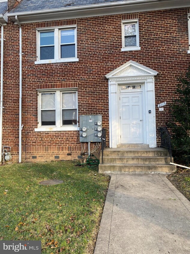
2115 2nd St NW
Washington, DC 20001
2 Weeks Ago
|
Edit
Favorites
2115 2nd St NW

Favorites
Check Back Soon for Upcoming Availability
| Beds | Baths | Average SF |
|---|---|---|
| 1 Bedroom 1 Bedroom 1 Br | 1 Bath 1 Bath 1 Ba | 3,132 SF |
2115 2nd St NW is a house located in District of Columbia County and the 20001 ZIP Code. This area is served by the District Of Columbia Public Schools attendance zone.
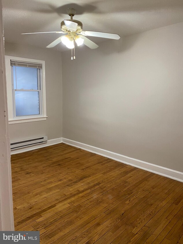
House Features
- Air Conditioning
Location
Get Directions
Roughly two miles north of the eastern end of the National Mall, Bloomingdale is a small neighborhood of about 12 blocks. It extends from Channing Street south to Florida Avenue, on the southeast side of Howard University. Bloomingdale is literally picture-perfect -- it was even featured in the opening credits of the Netflix series, House of Cards. The colorful brownstones with turrets aren't all people love about this popular neighborhood. It is the location of Crispus Attucks Park, a popular green space with terrific views.
Bloomingdale contains two commercial districts. The first, along Rhode Island Avenue, is packed with bars and restaurants -- including popular favorites the Red Hen and Bacio Pizzeria. Florida Avenue and North Capitol Street also offer restaurants, bars, and a few other businesses. While Bloomingdale doesn't have its own Metro station, bus stops are scattered throughout the neighborhood, taking residents quickly to nearby stops or into downtown DC.
Learn more about living in BloomingdaleBelow are rent ranges for similar nearby apartments
| Beds | Average Size | Lowest | Typical | Premium |
|---|---|---|---|---|
| Studio Studio Studio | 392-394 Sq Ft | $720 | $1,744 | $2,115 |
| 1 Bed 1 Bed 1 Bed | 569-576 Sq Ft | $945 | $1,871 | $2,550 |
| 2 Beds 2 Beds 2 Beds | 978-980 Sq Ft | $1,800 | $2,882 | $4,235 |
| 3 Beds 3 Beds 3 Beds | 1480 Sq Ft | $1,150 | $4,036 | $5,795 |
| 4 Beds 4 Beds 4 Beds | 2322 Sq Ft | $960 | $4,736 | $7,340 |
Amenities
- Air Conditioning
Education
| Colleges & Universities | Distance | ||
|---|---|---|---|
| Colleges & Universities | Distance | ||
| Walk: | 12 min | 0.6 mi | |
| Drive: | 3 min | 1.2 mi | |
| Drive: | 4 min | 1.6 mi | |
| Drive: | 4 min | 1.6 mi |
2115 2nd St NW is within 12 minutes or 0.6 mile from Howard University. It is also near Trinity Washington University and Georgetown.
Schools

Public Elementary School
Grades PK-5
338 Students
Attendance Zone
Public Middle School
Grades 6-8
222 Students
Attendance Zone
Public High School
Grades 9-12
868 Students
Attendance Zone
Private Elementary & Middle School
Grades 1-9
188 Students
Nearby
Private Elementary, Middle & High School
Grades 1-12
Nearby
School data provided by
 The GreatSchools Rating helps parents compare schools within a state based on a variety of school quality indicators and provides a helpful picture of how effectively each school serves all of its students. Ratings are on a scale of 1 (below average) to 10 (above average) and can include test scores, college readiness, academic progress, advanced courses, equity, discipline and attendance data. We also advise parents to visit schools, consider other information on school performance and programs, and consider family needs as part of the school selection process.
View GreatSchools Rating Methodology
Data provided by GreatSchools.org © 2025. All rights reserved.
View GreatSchools Rating Methodology
Data provided by GreatSchools.org © 2025. All rights reserved.
Transportation options available in Washington include Shaw-Howard U, located 0.7 mile from 2115 2nd St NW. 2115 2nd St NW is near Ronald Reagan Washington Ntl, located 6.7 miles or 13 minutes away, and Washington Dulles International, located 29.4 miles or 47 minutes away.
| Transit / Subway | Distance | ||
|---|---|---|---|
| Transit / Subway | Distance | ||
|
|
Walk: | 13 min | 0.7 mi |
|
|
Walk: | 15 min | 0.8 mi |
|
|
Drive: | 3 min | 1.2 mi |
|
|
Drive: | 3 min | 1.2 mi |
|
|
Drive: | 3 min | 1.6 mi |
| Commuter Rail | Distance | ||
|---|---|---|---|
| Commuter Rail | Distance | ||
|
|
Drive: | 4 min | 1.9 mi |
|
|
Drive: | 5 min | 2.0 mi |
|
|
Drive: | 6 min | 2.7 mi |
|
|
Drive: | 6 min | 2.7 mi |
|
|
Drive: | 10 min | 5.4 mi |
| Airports | Distance | ||
|---|---|---|---|
| Airports | Distance | ||
|
Ronald Reagan Washington Ntl
|
Drive: | 13 min | 6.7 mi |
|
Washington Dulles International
|
Drive: | 47 min | 29.4 mi |
Time and distance from 2115 2nd St NW.
| Shopping Centers | Distance | ||
|---|---|---|---|
| Shopping Centers | Distance | ||
| Drive: | 3 min | 1.3 mi | |
| Drive: | 4 min | 1.6 mi | |
| Drive: | 4 min | 1.8 mi |
2115 2nd St NW has 3 shopping centers within 1.8 miles, which is about a 4-minute drive. The miles and minutes will be for the farthest away property.
| Parks and Recreation | Distance | ||
|---|---|---|---|
| Parks and Recreation | Distance | ||
|
Carter G. Woodson Home National Historic Site
|
Walk: | 18 min | 1.0 mi |
|
Mary McLeod Bethune Council House NHS
|
Drive: | 4 min | 1.3 mi |
|
Marian Koshland Science Museum
|
Drive: | 4 min | 1.8 mi |
|
National Geographic Museum
|
Drive: | 5 min | 2.0 mi |
|
Meridian Hill Park
|
Drive: | 5 min | 2.2 mi |
2115 2nd St NW has 5 parks within 2.2 miles, including Carter G. Woodson Home National Historic Site, Mary McLeod Bethune Council House NHS, and Meridian Hill Park.
| Hospitals | Distance | ||
|---|---|---|---|
| Hospitals | Distance | ||
| Walk: | 9 min | 0.5 mi | |
| Drive: | 3 min | 1.2 mi | |
| Drive: | 4 min | 1.5 mi |
2115 2nd St NW has 3 hospitals within 1.5 miles, the nearest is Howard University Hospital which is 0.5 mile away and a 9 minute walk.
| Military Bases | Distance | ||
|---|---|---|---|
| Military Bases | Distance | ||
| Drive: | 4 min | 1.8 mi | |
| Drive: | 11 min | 4.8 mi |
2115 2nd St NW is 1.8 miles from US Soldiers & Airmens Home, and is convenient to other military bases, including Naval Observatory.
You May Also Like
Similar Rentals Nearby


What Are Walk Score®, Transit Score®, and Bike Score® Ratings?
Walk Score® measures the walkability of any address. Transit Score® measures access to public transit. Bike Score® measures the bikeability of any address.
What is a Sound Score Rating?
A Sound Score Rating aggregates noise caused by vehicle traffic, airplane traffic and local sources

2115 2nd St NW
Washington, DC 20001