$3,700 / Month
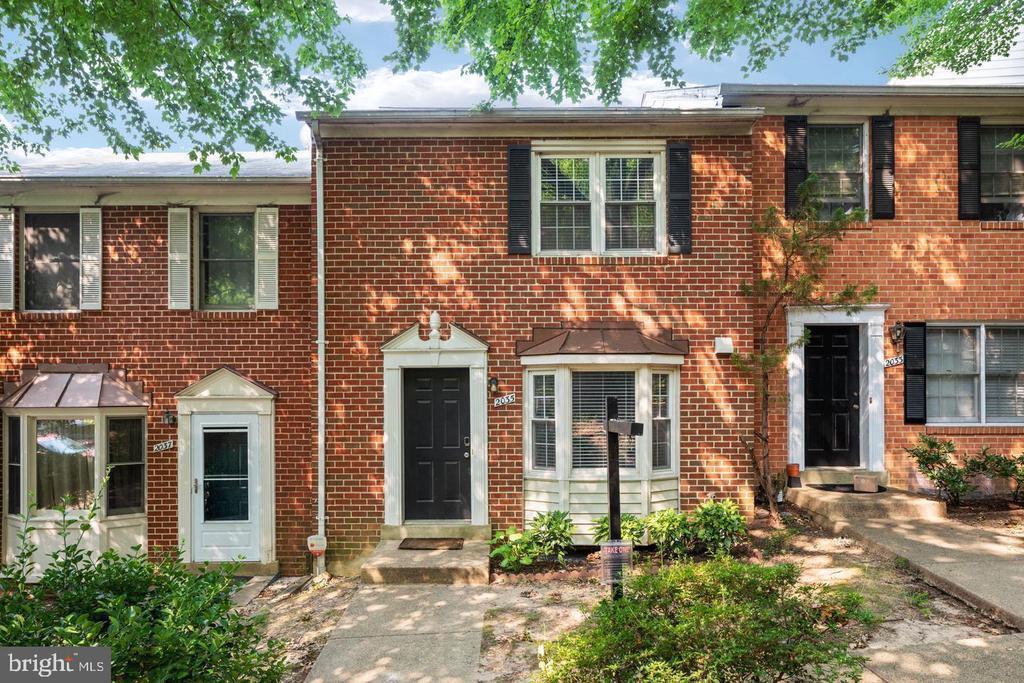
2035 S Glebe Rd
Arlington, VA 22204
Today
Favorites
-
Bedrooms
3
-
Bathrooms
3
-
Square Feet
--
Highlights
- Colonial Architecture
- Deck
- Wood Flooring
- Upgraded Countertops
- Stainless Steel Appliances
- Bay Window
2035 S Glebe Rd

Favorites
About This Home
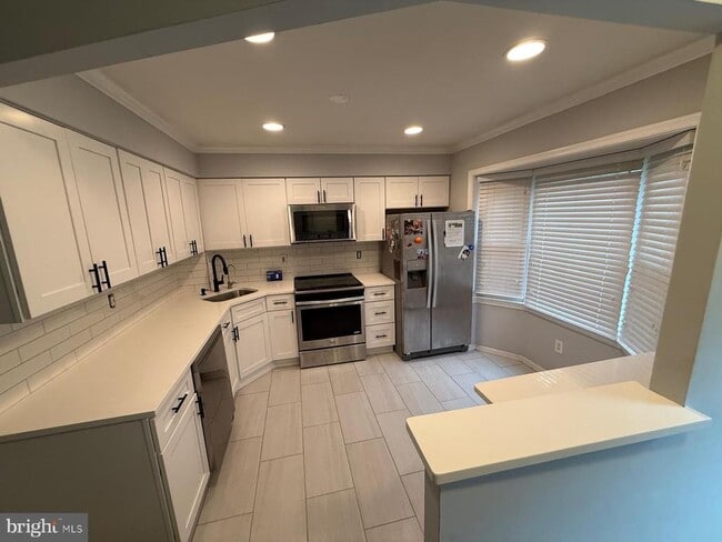
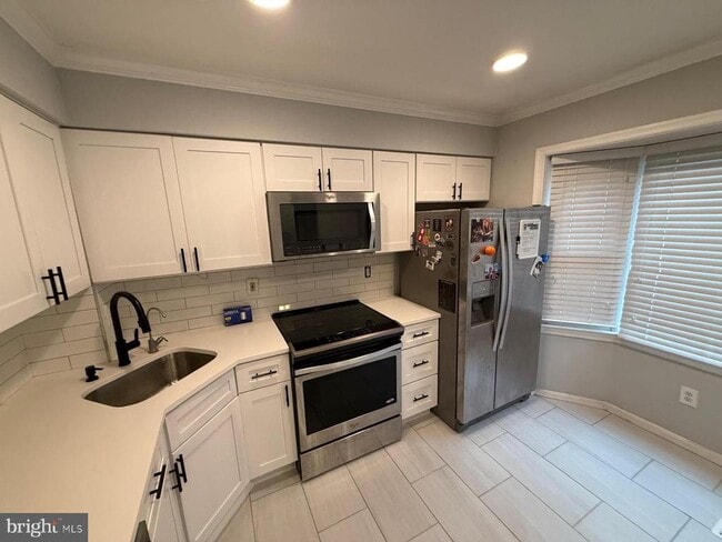
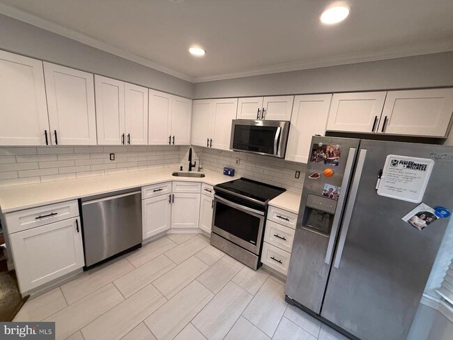
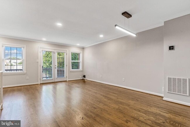
Location! Location! Location! Amazing 3 bedrooms, 3 bathrooms, townhome in Henson Park As you enter the main level, you're greeted by a bright and beautiful kitchen featuring stainless steel appliances, crown molding, and a charming bay window. The open-concept living and dining area with natural light, leads to the low-maintenance Armadillo composite deck, perfect for outdoor grilling or unwinding. Upstairs, you'll discover two spacious bedrooms, including a master suite with an updated bathroom, along with a second large bedroom and another full bathroom. On the same level, there's a stacked, front-load washer and dryer for added convenience, with an additional washer/dryer hookup available in the basement. The lower level boasts updated flooring, a third bedroom, a full bathroom that connects to extra storage space, and a separate living area complete with a wet bar and wine fridge. Step outside onto the fully fenced herringbone stone paver patio. 2 assigned parking spots in the back of the home. Conveniently located near the 395 express lanes, Shirlington, Columbia Pike, and Amazon headquarters, this property offers both comfort and convenience. Tenant must have agent!
2035 S Glebe Rd is a townhome located in Arlington County and the 22204 ZIP Code. This area is served by the Arlington County Public Schools attendance zone.
* Price shown is base rent and may not include non-optional fees and utilities.
Price, availability, fees, and any applicable rent special are subject to change without notice.
* Square footage definitions vary. Displayed square footage is approximate.
Home Details
Home Type
Interior Unit Townhome
Year Built
Built in 1988
Bedrooms and Bathrooms
3 Full Bathrooms
3 Bedrooms
Finished Basement
Walk-Out Basement
Connecting Stairway
Flooring
Wood
Ceramic Tile
Carpet
Home Design
Colonial Architecture
Brick Exterior Construction
Asphalt Roof
Concrete Perimeter Foundation
Home Security
Home Security System
Fire and Smoke Detector
Interior Spaces
Bay Window
Wet Bar
Crown Molding
French Doors
Combination Dining and Living Room
Ceiling Fan
1,728 Sq Ft Home
Property has 3 Levels
Kitchen
Upgraded Countertops
Stainless Steel Appliances
Stove
Built-In Microwave
Dishwasher
Wine Rack
Laundry
Dryer
Laundry on upper level
Washer
Listing and Financial Details
Security Deposit $4,200
12-Month Min and 24-Month Max Lease Term
Available 7/7/25
$50 Application Fee
Assessor Parcel Number 31-008-069
Tenant pays for all utilities
The owner pays for association fees
$100 Repair Deductible
No Smoking Allowed
Coming Soon on 6/19/25
Residential Lease
Lot Details
1,278 Sq Ft Lot
Property is in excellent condition
Back Yard Fenced
Outdoor Features
Deck
Patio
Parking
2 Assigned Parking Spaces
Schools
Drew Elementary School
Gunston Middle School
Wakefield High School
Utilities
Forced Air Heating and Cooling System
Electric Water Heater
Community Details
Overview
Property has a Home Owners Association
Property Manager
Henson Park Subdivision
Association fees include snow removal, common area maintenance
Pet Policy
No Pets Allowed
Contact
- Listed by Frank J Schofield | Summit Realtors
-
Source
 Bright MLS, Inc.
Copyright © 2025 Bright MLS, Inc.
Location
Get Directions
Amenities
- Dishwasher
- Basement
Across the Potomac River from Washington, DC, rests the Nauck neighborhood. The blue and yellow metro lines run along the river and wrap around the south end of the cemetery, while the orange and silver lines enter Arlington from DC just to the north of the cemetery. Commercial communities are built up around these metro stops to the north and south, while the area in between is largely residential.
From Interstate 395 up north to Wilson Boulevard the residential communities of Penrose and Lyon Park provide nice suburbs for those looking to be a bit removed from the hustle and bustle while maintaining access to amenities, albeit by car. Nauck also encompasses the Pentagon and houses many of its employees.
Learn more about living in Nauck
Education
| Colleges & Universities | Distance | ||
|---|---|---|---|
| Colleges & Universities | Distance | ||
| Drive: | 5 min | 2.2 mi | |
| Drive: | 9 min | 3.6 mi | |
| Drive: | 13 min | 5.3 mi | |
| Drive: | 11 min | 5.6 mi |
2035 S Glebe Rd is within 5 minutes or 2.2 miles from NOVA, Alexandira Campus. It is also near George Mason Univ., Arlington and Georgetown University.
Schools


Public Elementary School
Grades PK-5
469 Students
Attendance Zone
Public Middle School
Grades 6-8
1,111 Students
Attendance Zone
Public High School
Grades 9-12
2,766 Students
Attendance Zone
Private Elementary & Middle School
Grades PK-8
117 Students
Nearby
Private High School
Grades 9-12
450 Students
Nearby
School data provided by
 The GreatSchools Rating helps parents compare schools within a state based on a variety of school quality indicators and provides a helpful picture of how effectively each school serves all of its students. Ratings are on a scale of 1 (below average) to 10 (above average) and can include test scores, college readiness, academic progress, advanced courses, equity, discipline and attendance data. We also advise parents to visit schools, consider other information on school performance and programs, and consider family needs as part of the school selection process.
View GreatSchools Rating Methodology
Data provided by GreatSchools.org © 2025. All rights reserved.
View GreatSchools Rating Methodology
Data provided by GreatSchools.org © 2025. All rights reserved.
Transportation options available in Arlington include Pentagon City, located 3.0 miles from 2035 S Glebe Rd. 2035 S Glebe Rd is near Ronald Reagan Washington Ntl, located 3.6 miles or 8 minutes away, and Washington Dulles International, located 24.5 miles or 42 minutes away.
| Transit / Subway | Distance | ||
|---|---|---|---|
| Transit / Subway | Distance | ||
|
|
Drive: | 5 min | 3.0 mi |
|
|
Drive: | 6 min | 3.3 mi |
|
|
Drive: | 7 min | 3.4 mi |
|
|
Drive: | 7 min | 3.5 mi |
| Drive: | 8 min | 3.6 mi |
| Commuter Rail | Distance | ||
|---|---|---|---|
| Commuter Rail | Distance | ||
|
|
Drive: | 7 min | 3.4 mi |
|
|
Drive: | 10 min | 4.3 mi |
|
|
Drive: | 10 min | 4.3 mi |
|
|
Drive: | 10 min | 5.6 mi |
|
|
Drive: | 10 min | 5.6 mi |
| Airports | Distance | ||
|---|---|---|---|
| Airports | Distance | ||
|
Ronald Reagan Washington Ntl
|
Drive: | 8 min | 3.6 mi |
|
Washington Dulles International
|
Drive: | 42 min | 24.5 mi |
Time and distance from 2035 S Glebe Rd.
| Shopping Centers | Distance | ||
|---|---|---|---|
| Shopping Centers | Distance | ||
| Walk: | 17 min | 0.9 mi | |
| Walk: | 17 min | 0.9 mi | |
| Walk: | 18 min | 1.0 mi |
2035 S Glebe Rd has 3 shopping centers within 1.0 mile, which is about a 18-minute walk. The miles and minutes will be for the farthest away property.
| Parks and Recreation | Distance | ||
|---|---|---|---|
| Parks and Recreation | Distance | ||
|
Douglas Park
|
Walk: | 14 min | 0.8 mi |
|
Shirlington Park
|
Drive: | 3 min | 1.3 mi |
|
Lucky Run Park
|
Drive: | 3 min | 1.3 mi |
|
Four Mile Run Park
|
Drive: | 3 min | 1.6 mi |
|
Allie S. Freed Park
|
Drive: | 5 min | 1.7 mi |
2035 S Glebe Rd has 5 parks within 1.7 miles, including Douglas Park, Shirlington Park, and Lucky Run Park.
| Hospitals | Distance | ||
|---|---|---|---|
| Hospitals | Distance | ||
| Drive: | 7 min | 3.5 mi | |
| Drive: | 9 min | 3.5 mi | |
| Drive: | 10 min | 3.9 mi |
2035 S Glebe Rd has 3 hospitals within 3.9 miles, the nearest is Inova Alexandria Hospital which is 3.5 miles away and a 7 minute drive.
You May Also Like
Similar Rentals Nearby


What Are Walk Score®, Transit Score®, and Bike Score® Ratings?
Walk Score® measures the walkability of any address. Transit Score® measures access to public transit. Bike Score® measures the bikeability of any address.
What is a Sound Score Rating?
A Sound Score Rating aggregates noise caused by vehicle traffic, airplane traffic and local sources

2035 S Glebe Rd
Arlington, VA 22204