2025 Pine St
2025 Pine St,
San Francisco,
CA
94115
2 Weeks Ago
Favorites
2025 Pine St

Favorites
Check Back Soon for Upcoming Availability
Fees and Policies
The fees below are based on community-supplied data and may exclude additional fees and utilities.
- Cats Allowed
-
Fees not specified
-
Weight limit--
-
Pet Limit--
- Parking
-
Garage$250/mo
Details
Lease Options
-
12 Months
About 2025 Pine St San Francisco, CA 94115
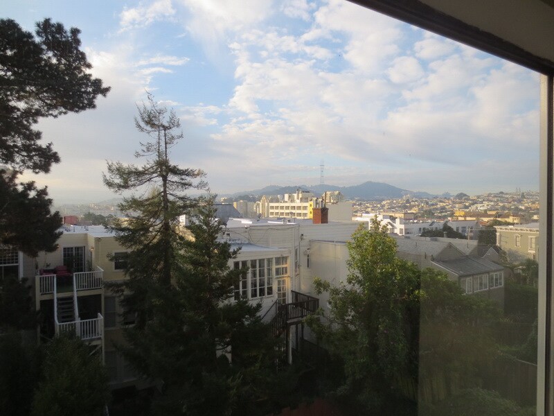
Available immediately, this unit is located at 2025 Pine Street in Pacific Heights. Cross streets are Laguna & Buchanan. The unit is in the back of the building, away from traffic on the 2nd floor of a 4 story building. The Unit has 1 bedroom, a large living room with a spectacular view of Twin Peaks. The unit has a large eat-in updated kitchen with new floor and new appliances. It has a spacious updated full bathroom with new counter top and wash basin. It features near new installed wall to wall carpet. It has wall-mounted gas heater. Garbage and water (hot and cold) are included. Elevator and laundry facility are in the building. Muni bus lines (1, 2, 3, 22 & 38) are within couple of blocks. One reserved parking place is available at extra charge in the underground garage with remote garage opener. This unit is located a few blocks from the Fillmore district, Japan Town and Webster Shopping Complex with numerous cafes and restaurants. Close to major supermarket including Safeway, Trader Joe’s, Whole Foods and Molly Stone. Walgreen’s is close by. City Target and Best Buy are about 5 minute drive from the building. It is also close to banks, post office and the Pacific Campus of the California Pacific Medical Center. Great neighborhood at 2025 Pine Street Call Wendy at (415) 751-9880 or (415) 335-5973 for more information or an appointment to view the unit. Please note, we show the unit by APPOINTMENT only.
2025 Pine St is an apartment community located in San Francisco County and the 94115 ZIP Code.
Apartment Features
- Laundry Facilities
Location
Get Directions
Lower Pacific Heights is a vibrant San Francisco neighborhood situated between Pacific Heights, Japantown, the Fillmore District, and Laurel Heights. Formerly known as Upper Fillmore, Lower Pacific Heights offers residents a wide variety of apartments, condos, and houses available for rent, many of which boast scenic views due to the neighborhood’s hilly environment.
Lower Pacific Heights is regarded for its walkable layout, with many rentals situated within easy walking distance of the diverse restaurants, shops, coffeehouses, and bars that line Fillmore Street, the community’s main commercial thoroughfare. The neighborhood’s central locale is a major part of its allure, providing quick access to Union Square, the University of San Francisco, the Financial District, several prominent medical centers, tech employers, landmarks, and more.
Learn more about living in Lower Pacific HeightsBelow are rent ranges for similar nearby apartments
Amenities
- Laundry Facilities
Expenses
Recurring
Unassigned Garage Parking
$250
Education
| Colleges & Universities | Distance | ||
|---|---|---|---|
| Colleges & Universities | Distance | ||
| Walk: | 13 min | 0.7 mi | |
| Drive: | 4 min | 1.4 mi | |
| Drive: | 5 min | 1.8 mi | |
| Drive: | 6 min | 2.1 mi |
2025 Pine St is within 13 minutes or 0.7 mile from UC San Francisco, Mount Zion. It is also near Academy of Art University and University of San Francisco.
Transportation options available in San Francisco include Van Ness And California, located 0.5 mile from 2025 Pine St. 2025 Pine St is near San Francisco International, located 14.8 miles or 24 minutes away, and Metro Oakland International, located 20.6 miles or 33 minutes away.
| Transit / Subway | Distance | ||
|---|---|---|---|
| Transit / Subway | Distance | ||
|
|
Walk: | 9 min | 0.5 mi |
|
|
Walk: | 12 min | 0.7 mi |
|
|
Walk: | 14 min | 0.7 mi |
|
|
Walk: | 17 min | 0.9 mi |
|
|
Drive: | 3 min | 1.1 mi |
| Commuter Rail | Distance | ||
|---|---|---|---|
| Commuter Rail | Distance | ||
| Drive: | 7 min | 2.6 mi | |
| Drive: | 7 min | 2.7 mi | |
| Drive: | 9 min | 4.1 mi | |
| Drive: | 9 min | 4.2 mi | |
| Drive: | 13 min | 6.9 mi |
| Airports | Distance | ||
|---|---|---|---|
| Airports | Distance | ||
|
San Francisco International
|
Drive: | 24 min | 14.8 mi |
|
Metro Oakland International
|
Drive: | 33 min | 20.6 mi |
Time and distance from 2025 Pine St.
| Shopping Centers | Distance | ||
|---|---|---|---|
| Shopping Centers | Distance | ||
| Walk: | 5 min | 0.3 mi | |
| Walk: | 9 min | 0.5 mi | |
| Drive: | 5 min | 1.6 mi |
2025 Pine St has 3 shopping centers within 1.6 miles, which is about a 5-minute walk. The miles and minutes will be for the farthest away property.
| Parks and Recreation | Distance | ||
|---|---|---|---|
| Parks and Recreation | Distance | ||
|
Children's Creativity Museum
|
Drive: | 6 min | 2.0 mi |
|
San Francisco Maritime National Historical Park
|
Drive: | 6 min | 2.1 mi |
|
Buena Vista Park
|
Drive: | 6 min | 2.1 mi |
|
Exploratorium
|
Drive: | 5 min | 2.2 mi |
|
Randall Museum
|
Drive: | 7 min | 2.6 mi |
2025 Pine St has 5 parks within 2.6 miles, including San Francisco Maritime National Historical Park, Children's Creativity Museum, and Exploratorium.
| Hospitals | Distance | ||
|---|---|---|---|
| Hospitals | Distance | ||
| Walk: | 12 min | 0.6 mi | |
| Walk: | 14 min | 0.7 mi | |
| Drive: | 4 min | 1.4 mi |
2025 Pine St has 3 hospitals within 1.4 miles, the nearest is California Pacific Medical Center - Van Ness Campus which is 0.6 mile away and a 12 minute walk.
| Military Bases | Distance | ||
|---|---|---|---|
| Military Bases | Distance | ||
| Drive: | 12 min | 4.2 mi | |
| Drive: | 13 min | 4.6 mi | |
| Drive: | 16 min | 6.7 mi |
2025 Pine St has 3 military bases within 6.7 miles, the nearest is East Fort Miley which is 4.2 miles away and a 12 minute drive.
You May Also Like
Similar Rentals Nearby


What Are Walk Score®, Transit Score®, and Bike Score® Ratings?
Walk Score® measures the walkability of any address. Transit Score® measures access to public transit. Bike Score® measures the bikeability of any address.
What is a Sound Score Rating?
A Sound Score Rating aggregates noise caused by vehicle traffic, airplane traffic and local sources