
2017 Laurel Avenue
Saint Paul, MN 55104
-
Bedrooms
2
-
Bathrooms
1
-
Square Feet
1,100 sq ft
-
Available
Available Jul 1
Highlights
- Hardwood Floors
- Smoke Free

2 Available Units
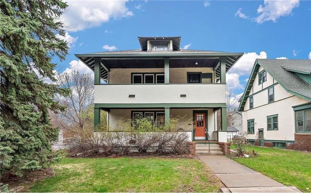
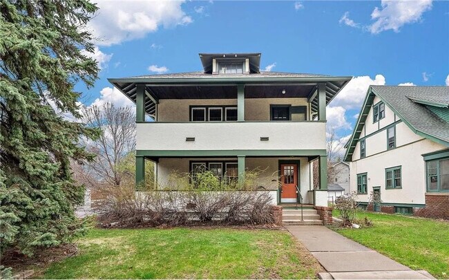
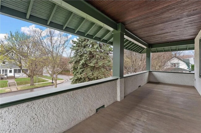
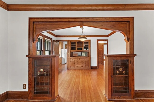
Traditional Craftsman duplex with hardwood floors, stain glass window, built-in buffet and original woodwork. Large front porch, kitchen pantry, dishwasher, free on-site laundry and storage unit • on-street parking available with permit • 1 window air conditioning unit provided Walk/bike to: Restaurants and coffee shops • Whole Foods Market • Shopping on Grand Avenue • Historic Summit Avenue • Mississippi River walking and biking trails • Bus lines • University of St Thomas and Macalester College Minimum Lease: month to month, Deposit: $1635 Background check (criminal and credit) which applicant pays for, proof of income and references required. Rent includes: •water, garbage, recycling, sewer, lawn care Tenant pays for: electricity, gas, cable, internet, snow removal under 2” no smoking • no pets unless licensed ESA. Rent includes occupancy of 2 people. Each additional person will add $30 to the rent. This is to offset increase in water bill for additional people.
2017 Laurel Avenue is a townhome located in Ramsey County and the 55104 ZIP Code.
Townhome Features
Air Conditioning
Dishwasher
Hardwood Floors
Smoke Free
- Air Conditioning
- Smoke Free
- Dishwasher
- Hardwood Floors
- Laundry Facilities
- Storage Space
Fees and Policies
The fees listed below are community-provided and may exclude utilities or add-ons. All payments are made directly to the property and are non-refundable unless otherwise specified.
- Parking
-
Street--
Details
Utilities Included
-
Water
-
Trash Removal
-
Sewer
Lease Options
-
9 - 12 Month Leases
Property Information
-
2 units
Contact
- Contact
Along the shore of the Mississippi River, Merriam Park West offers riverfront parks, a large golf course, and quaint local restaurants just minutes from downtown Saint Paul, Minnesota. Stop on in at Izzy’s Ice Cream Café, or grab a treat at Black Coffee and Waffle Bar. Local businesses thrive alongside riverfront community spaces like Shadow Falls Park, a picturesque nature preserve.
The University of Saint Thomas resides on the south end of town, and the neighborhood offers a blend of private and public schools, churches, and every day conveniences. Situated just five miles southeast of Minneapolis and seven miles northeast of the Minneapolis-Saint Paul International Airport, this neighborhood is in a premier location for commuting, shopping, dining, and entertainment.
Learn more about living in Merriam Park West| Colleges & Universities | Distance | ||
|---|---|---|---|
| Colleges & Universities | Distance | ||
| Walk: | 10 min | 0.6 mi | |
| Drive: | 3 min | 1.7 mi | |
| Drive: | 3 min | 1.9 mi | |
| Drive: | 6 min | 1.9 mi |
Transportation options available in Saint Paul include Fairview Ave Station, located 1.2 miles from 2017 Laurel Avenue. 2017 Laurel Avenue is near Minneapolis-St Paul International/Wold-Chamberlain, located 6.7 miles or 15 minutes away.
| Transit / Subway | Distance | ||
|---|---|---|---|
| Transit / Subway | Distance | ||
| Drive: | 2 min | 1.2 mi | |
| Drive: | 4 min | 1.7 mi | |
| Drive: | 5 min | 1.8 mi | |
| Drive: | 4 min | 2.1 mi | |
| Drive: | 5 min | 2.3 mi |
| Commuter Rail | Distance | ||
|---|---|---|---|
| Commuter Rail | Distance | ||
|
|
Drive: | 10 min | 5.7 mi |
|
|
Drive: | 14 min | 6.4 mi |
|
|
Drive: | 22 min | 14.9 mi |
|
|
Drive: | 32 min | 23.7 mi |
|
|
Drive: | 33 min | 25.4 mi |
| Airports | Distance | ||
|---|---|---|---|
| Airports | Distance | ||
|
Minneapolis-St Paul International/Wold-Chamberlain
|
Drive: | 15 min | 6.7 mi |
Scores provided by
Traffic
-Airport
-Businesses
-Scores provided by
HowLoud What is a Sound Score Rating? A Sound Score Rating aggregates noise caused by vehicle traffic, airplane traffic and local sources. How It WorksTime and distance from 2017 Laurel Avenue.
| Shopping Centers | Distance | ||
|---|---|---|---|
| Shopping Centers | Distance | ||
| Drive: | 4 min | 1.8 mi | |
| Drive: | 5 min | 1.9 mi |
| Parks and Recreation | Distance | ||
|---|---|---|---|
| Parks and Recreation | Distance | ||
|
Macalester College Observatory
|
Drive: | 3 min | 1.9 mi |
|
Brackett Park
|
Drive: | 6 min | 2.1 mi |
|
Newell Park
|
Drive: | 4 min | 2.1 mi |
|
Longfellow Park
|
Drive: | 6 min | 2.5 mi |
|
Hiawatha School Park
|
Drive: | 9 min | 3.1 mi |
| Hospitals | Distance | ||
|---|---|---|---|
| Hospitals | Distance | ||
| Drive: | 7 min | 3.7 mi | |
| Drive: | 11 min | 4.3 mi | |
| Drive: | 9 min | 4.7 mi |
| Military Bases | Distance | ||
|---|---|---|---|
| Military Bases | Distance | ||
| Drive: | 14 min | 5.4 mi |
- Air Conditioning
- Smoke Free
- Dishwasher
- Hardwood Floors
- Laundry Facilities
- Storage Space
2017 Laurel Avenue Photos
What Are Walk Score®, Transit Score®, and Bike Score® Ratings?
Walk Score® measures the walkability of any address. Transit Score® measures access to public transit. Bike Score® measures the bikeability of any address.
What is a Sound Score Rating?
A Sound Score Rating aggregates noise caused by vehicle traffic, airplane traffic and local sources.

2017 Laurel Avenue
Saint Paul, MN 55104