$2,250
/ Month
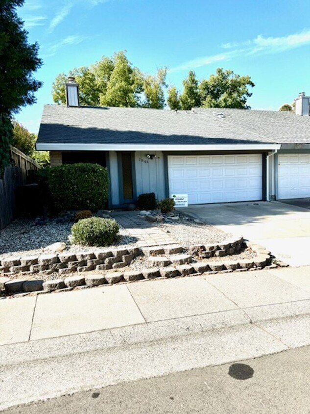
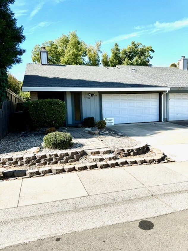
2010A Inglis Way
Roseville, CA 95678
Favorites
916-871-6317
-
Bedrooms
2
-
Bathrooms
2
-
Square Feet
1,086 sq ft
-
Available
Available May 25
2010A Inglis Way

Favorites
About This Home
$2,250 deposit,
Available May 25
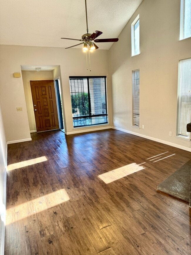
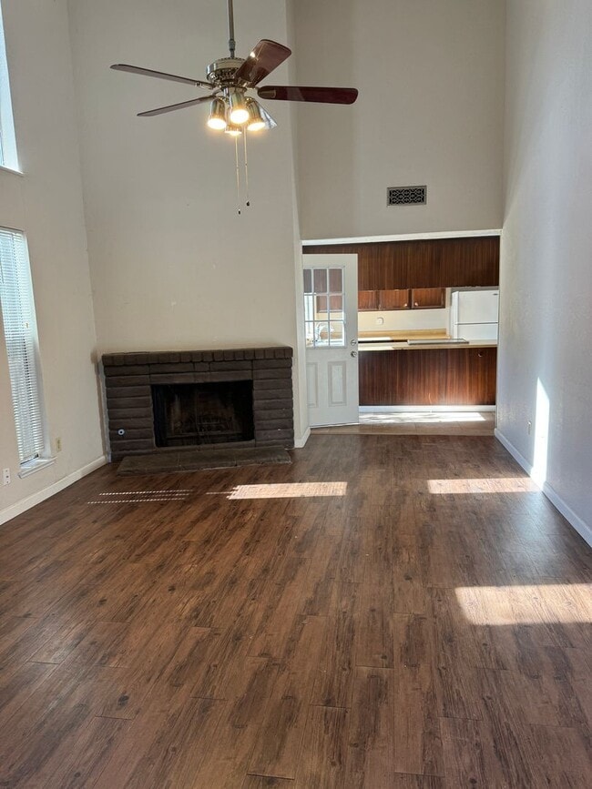
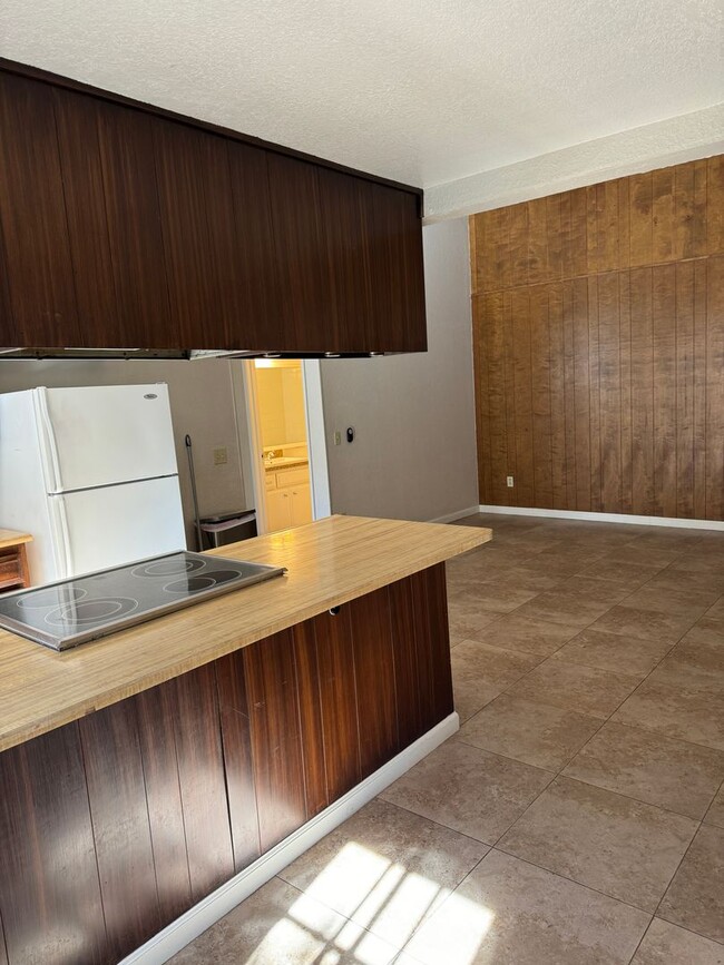
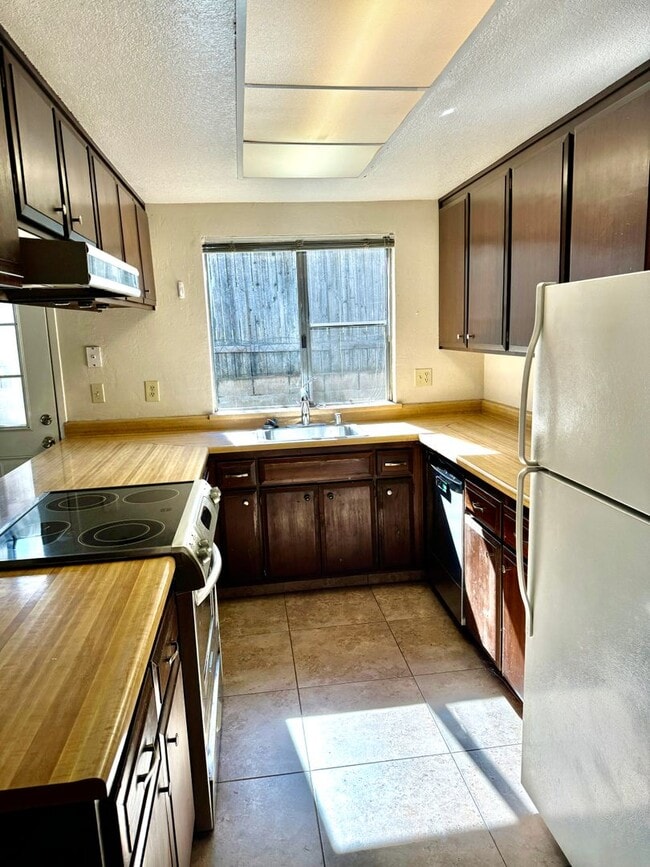
Thanks for your interest in 2010-A Inglis Way in Roseville! * * VIDEO TOUR INFO BELOW * * - $2,250 per month - $2,250 security deposit - 1,086 sqft - 2 bedrooms - 2 bathrooms - Owner pays sewer - Renters insurance required - Very convenient location!!! - 1 Dog ok with $40 per month pet rent - To Qualify: must have a minimum credit score of 650 and good/great references * * VIDEO TOUR: Click this link: or type "2010-A Inglis Way" into YouTube * * Please contact us to schedule a showing.
Unique Features
- sewer
2010A Inglis Way is a townhome located in Placer County and the 95678 ZIP Code. This area is served by the Roseville City Elementary School District attendance zone.
* Price shown is base rent. Excludes user-selected optional fees and variable or usage-based fees and required charges due at or prior to move-in or at move-out. Price, availability, fees, and any applicable rent special are subject to change without notice.
* Square footage definitions vary. Displayed square footage is approximate.
Fees and Policies
The fees listed below are community-provided and may exclude utilities or add-ons. All payments are made directly to the property and are non-refundable unless otherwise specified. Use the Cost Calculator to determine costs based on your needs.
-
One-Time Basics
-
Due at Move-In
-
Security Deposit - RefundableCharged per unit.$2,250
-
-
Due at Move-In
-
Dogs
-
Allowed
-
Property Fee Disclaimer: Based on community-supplied data and independent market research. Subject to change without notice. May exclude fees for mandatory or optional services and usage-based utilities.
Townhome Features
- Refrigerator
Contact
- Listed by Whitney Oaks Realty, Inc. | Whitney Oaks Realty, Inc.
- Phone Number
- Contact
Location
Get Directions
Located in the Sacramento Valley, Roseville combines residential comfort with city conveniences. The city offers diverse housing options throughout its neighborhoods, from newer developments near Westfield Galleria to historic properties in Old Town. Current rental trends show steady market conditions, with one-bedroom apartments averaging $1,921 per month, while larger three-bedroom units typically rent for $2,780. The city's rental market has remained relatively stable, with modest year-over-year increases ranging from 0.9% to 2.3% across different unit sizes.
What began as a railroad town has evolved into a shopping and entertainment hub that maintains its small-town atmosphere. The Fountains at Roseville and Westfield Galleria provide extensive retail options, while Maidu Regional Park and Royer Park offer recreational spaces. Major employers like Kaiser Permanente and Hewlett Packard Enterprise contribute to local employment opportunities.
Learn more about living in Roseville
Amenities
- Refrigerator
- sewer
Education
| Colleges & Universities | Distance | ||
|---|---|---|---|
| Colleges & Universities | Distance | ||
| Drive: | 12 min | 7.5 mi | |
| Drive: | 14 min | 7.6 mi | |
| Drive: | 28 min | 14.2 mi | |
| Drive: | 24 min | 15.9 mi |
2010A Inglis Way is within 14 minutes or 7.6 miles from American River College. It is also near Sierra College, Rocklin Campus and Folsom Lake College, Folsom.
Schools


Public Elementary School
Grades K-5
450 Students
Nearby
Public Elementary School
Grades K-5
370 Students
Attendance Zone
Public Elementary & Middle School
Grades PK-8
380 Students
Nearby
Public Middle School
Grades 6-8
939 Students
Attendance Zone
Charter High School
Grades 9-12
15 Students
Nearby
Public High School
Grades 9-12
1,290 Students
Attendance Zone
Private Elementary & Middle School
Grades PK-8
213 Students
Nearby
Private High School
Grades 9-12
12 Students
Nearby
School data provided by
 The GreatSchools Rating helps parents compare schools within a state based on a variety of school quality indicators and provides a helpful picture of how effectively each school serves all of its students. Ratings are on a scale of 1 (below average) to 10 (above average) and can include test scores, college readiness, academic progress, advanced courses, equity, discipline and attendance data. We also advise parents to visit schools, consider other information on school performance and programs, and consider family needs as part of the school selection process.
View GreatSchools Rating Methodology
Data provided by GreatSchools.org © 2026. All rights reserved.
View GreatSchools Rating Methodology
Data provided by GreatSchools.org © 2026. All rights reserved.
Transportation options available in Roseville include Watt/I-80, located 8.3 miles from 2010A Inglis Way. 2010A Inglis Way is near Sacramento International, located 23.5 miles or 31 minutes away.
| Transit / Subway | Distance | ||
|---|---|---|---|
| Transit / Subway | Distance | ||
|
|
Drive: | 11 min | 8.3 mi |
|
|
Drive: | 13 min | 9.6 mi |
| Drive: | 13 min | 10.1 mi | |
|
|
Drive: | 19 min | 11.3 mi |
|
|
Drive: | 21 min | 12.2 mi |
| Commuter Rail | Distance | ||
|---|---|---|---|
| Commuter Rail | Distance | ||
|
|
Drive: | 6 min | 2.6 mi |
|
|
Drive: | 11 min | 6.7 mi |
| Drive: | 21 min | 16.8 mi | |
| Drive: | 24 min | 18.9 mi | |
|
|
Drive: | 24 min | 18.9 mi |
| Airports | Distance | ||
|---|---|---|---|
| Airports | Distance | ||
|
Sacramento International
|
Drive: | 31 min | 23.5 mi |
Getting Around
 What do Walkability, Transit, Drivability, and Bikeability mean?
Walkability measures the walking distance to day-to-day needs.
Transit measures access to public transportation.
Drivability measures congestion, parking availability, and access to major roads.
Bikeability measures the suitability for cycling.
How It Works
What do Walkability, Transit, Drivability, and Bikeability mean?
Walkability measures the walking distance to day-to-day needs.
Transit measures access to public transportation.
Drivability measures congestion, parking availability, and access to major roads.
Bikeability measures the suitability for cycling.
How It Works
Fairly Walkable
Walkability
40
/ 100
Limited Public Transit
Transit
30
/ 100
Exceptionally Drivable
Drivability
90
/ 100
Fairly Bikeable
Bikeability
50
/ 100
Scores provided by
Active
Soundscore™
73
/ 100
Traffic
ActiveAirport
CalmBusinesses
ActiveScores provided by
HowLoud What is a Sound Score Rating? A Sound Score Rating aggregates noise caused by vehicle traffic, airplane traffic and local sources. How It WorksTime and distance from 2010A Inglis Way.
| Shopping Centers | Distance | ||
|---|---|---|---|
| Shopping Centers | Distance | ||
| Walk: | 7 min | 0.4 mi | |
| Walk: | 8 min | 0.5 mi |
2010A Inglis Way has 2 shopping centers within 0.5 mile, which is about a 8-minute walk. The miles and minutes will be for the farthest away property.
| Parks and Recreation | Distance | ||
|---|---|---|---|
| Parks and Recreation | Distance | ||
|
Mahany Park
|
Drive: | 9 min | 4.5 mi |
|
Mahan Park
|
Drive: | 12 min | 6.6 mi |
|
Luken Park
|
Drive: | 12 min | 6.7 mi |
|
Roccucci Park
|
Drive: | 14 min | 7.9 mi |
|
Gibson Ranch County Park
|
Drive: | 17 min | 8.3 mi |
2010A Inglis Way has 5 parks within 8.3 miles, including Mahany Park, Luken Park, and Mahan Park.
| Hospitals | Distance | ||
|---|---|---|---|
| Hospitals | Distance | ||
| Drive: | 8 min | 4.8 mi | |
| Drive: | 9 min | 4.9 mi | |
| Drive: | 11 min | 5.8 mi |
2010A Inglis Way has 3 hospitals within 5.8 miles, the nearest is Kaiser Foundation Hospital - Roseville which is 4.8 miles away and a 8 minute drive.
| Military Bases | Distance | ||
|---|---|---|---|
| Military Bases | Distance | ||
| Drive: | 22 min | 9.4 mi | |
| Drive: | 57 min | 35.6 mi | |
| Drive: | 71 min | 56.4 mi |
2010A Inglis Way has 3 military bases within 56.4 miles, the nearest is McClellan Air Force Base which is 9.4 miles away and a 22 minute drive.
You May Also Like
Similar Rentals Nearby
-
-
2 Beds$2,356+3 Beds$3,0564 Beds$3,356+Total Monthly PriceTotal Monthly Price NewPrices include base rent and required monthly fees of $60. Variable costs based on usage may apply.Base Rent:2 Beds$2,295+3 Beds$2,9954 Beds$3,295+Specials
Pets Allowed Fitness Center Pool In Unit Washer & Dryer Clubhouse Stainless Steel Appliances Package Service
-
-
-
-
-
-
-
2 Beds$2,153+3 Beds$2,689+Total Monthly PriceTotal Monthly Price NewPrices include base rent and required monthly fees. Variable costs based on usage may apply.
Pets Allowed Fitness Center In Unit Washer & Dryer Stainless Steel Appliances Grill Basketball Court
-


What Are Walk Score®, Transit Score®, and Bike Score® Ratings?
Walk Score® measures the walkability of any address. Transit Score® measures access to public transit. Bike Score® measures the bikeability of any address.
What is a Sound Score Rating?
A Sound Score Rating aggregates noise caused by vehicle traffic, airplane traffic and local sources.
2010A Inglis Way
Roseville, CA 95678