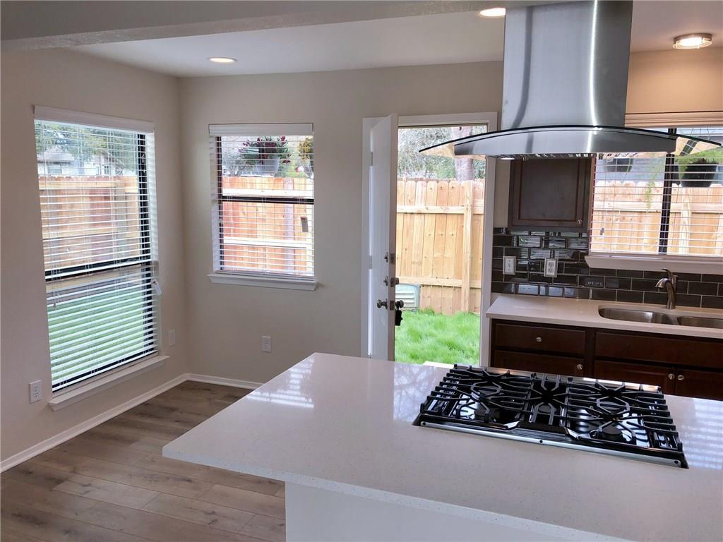
$1,550 / Month

2008 Conestoga Trail

,

Austin, TX 78744

Share Listing
Favorites
512-924-6966
  • Bedrooms

    2

  • Bathrooms

    2

  • Square Feet

    1,692 sq ft

  • Available

    Available Now

Highlights

  • Wooded Lot
  • Vaulted Ceiling
  • Corner Lot
  • Quartz Countertops
  • Private Yard
  • Stainless Steel Appliances
2008 Conestoga Trail
Share Listing
Favorites

About This Home

Available Now

VACANT & READY!!! One story 2–2 with carport and lots of updates…Silestone kitchen and baths…Stainless appliances including chimney range hood and counter depth fridge….Wonderful open kitchen/dining/living with vaulted ceiling and fireplace….Front load washer and dryer….Tankless water heater. Building is on a corner lot…actually faces Ponciana. MLS ID 1879800

2008 Conestoga Trail is a townhome located in Travis County and the 78744 ZIP Code. This area is served by the Austin Independent School District attendance zone.

* Price shown is base rent. Excludes user-selected optional fees and variable or usage-based fees and required charges due at or prior to move-in or at move-out. Price, availability, fees, and any applicable rent special are subject to change without notice.
* Square footage definitions vary. Displayed square footage is approximate.

Home Details

Home Type

Duplex

Year Built

Built in 1981

Accessible Home Design

No Interior Steps Accessible Doors

Bedrooms and Bathrooms

2 Main Level Bedrooms 2 Full Bathrooms

Flooring

Tile Vinyl

Home Design

Stone Siding Metal Roof Slab Foundation Frame Construction

Interior Spaces

Great Room with Fireplace Vaulted Ceiling Recessed Lighting 1-Story Property 1,692 Sq Ft Home Aluminum Window Frames

Kitchen

Quartz Countertops Stainless Steel Appliances Breakfast Bar Gas Range Free-Standing Range Dishwasher Self-Cleaning Oven Disposal

Laundry

Laundry in Hall Stacked Washer and Dryer

Listing and Financial Details

Security Deposit $1,550 12 Month Lease Term $50 Application Fee Assessor Parcel Number 04180108230000 Tax Block C Tenant pays for all utilities The owner pays for taxes

Lot Details

8,276 Sq Ft Lot Wooded Lot Corner Lot Private Yard West Facing Home Wood Fence Chain Link Fence

Parking

Carport 1 Car Garage Off-Street Parking

Schools

Houston Elementary School Mendez Middle School Travis High School

Utilities

Tankless Water Heater Central Heating and Cooling System High Speed Internet Heating System Uses Natural Gas Vented Exhaust Fan

Community Details

Overview

2 Units No Home Owners Association Property managed by Robinson Co., REALTORS Wagon Crossing Sec 03 A Amd Subdivision

Pet Policy

Dogs and Cats Allowed Breed Restrictions Pet Size Limit Pet Deposit $300

Fees and Policies

The fees listed below are community-provided and may exclude utilities or add-ons. All payments are made directly to the property and are non-refundable unless otherwise specified.

  • Dogs
    • Allowed
  • Cats
    • Allowed

Property Fee Disclaimer: Based on community-supplied data and independent market research. Subject to change without notice. May exclude fees for mandatory or optional services and usage-based utilities.

Contact

  • Listed by Clint Robinson | Robinson Co., REALTORS
  • Phone Number
  • Contact
  • Source
    Austin Board of REALTORS®
The information included in this listing is provided exclusively for consumers’ personal, non-commercial use and may not be used for any purpose other than to identify prospective properties consumers may be interested in purchasing. The information on each listing is furnished by the owner and deemed reliable to the best of his/her knowledge, but should be verified by the purchaser. ABoR, ACTRIS and Estately assume no responsibility for typographical errors, misprints or misinformation. This property listing is offered without respect to any protected classes in accordance with the law. Copyright © 2026.
| Edit

Under 30 minutes

Commute Time is calculated at rush hour.
Neighborhood

On the west side of McKinney Falls State Park along I-35 is where you’ll find Franklin Park, a charming suburban community that’s been housing renters since the 1970s. The neighborhood is dominated by ranch-style homes, some of which have received charming renovations as this part of Austin explodes with prospective tenants.

On Franklin Park’s southern border is the Williamson Creek Greenbelt, which snakes for miles throughout south Austin. The nearby state park puts further emphasis on how much this area values its green space. There are a number of fantastic, specialized schools that serve the area, making Franklin Park ideal for families. And with the Downtown Austin just six miles away, you’ll never be too far from the conveniences of the city.

Learn more about living in Franklin Park 
Amenities
  • Dishwasher
  • Disposal
  • Refrigerator
  • Tile Floors
  • Vinyl Flooring
Education
Colleges & Universities Distance
Drive: 5 min 2.8 mi
Drive: 7 min 3.8 mi
Drive: 11 min 5.6 mi
Drive: 11 min 7.4 mi
2008 Conestoga Trail is within 5 minutes or 2.8 miles from Austin C.C., South Austin. It is also near St. Edward's University and Austin C.C., Riverside Campus.
Schools
Public Elementary School
Grades PK-5
527 Students
Attendance Zone
Public Middle School
Grades 6-8
223 Students
Attendance Zone
Public High School
Grades 9-12
1,137 Students
Attendance Zone
Private Elementary & Middle School
Grades PK-8
103 Students
Nearby
Private Middle & High School
Grades 6-12
Nearby
Transportation

Transportation options available in Austin include Downtown Station, located 5.7 miles from 2008 Conestoga Trail. 2008 Conestoga Trail is near Austin-Bergstrom International, located 8.7 miles or 19 minutes away.

Transit / Subway Distance
Drive: 8 min 5.7 mi
Drive: 9 min 6.3 mi
Drive: 12 min 8.0 mi
Drive: 15 min 10.3 mi
Commuter Rail Distance
Drive: 12 min 7.3 mi
Drive: 32 min 26.2 mi
Drive: 51 min 41.3 mi
Airports Distance
Airports Distance
Austin-Bergstrom International
Drive: 19 min 8.7 mi
Getting Around
Fairly Walkable
Walkability
50 / 100
Limited Public Transit
Transit
30 / 100
Exceptionally Drivable
Drivability
90 / 100
Fairly Bikeable
Bikeability
50 / 100

Scores provided by

What do Walkability, Transit, Drivability, and Bikeability mean? Walkability measures the walking distance to day-to-day needs. Transit measures access to public transportation. Drivability measures congestion, parking availability, and access to major roads. Bikeability measures the suitability for cycling. How It Works
-
Soundscore
- / 100

Traffic

-

Airport

-

Businesses

-

Scores provided by

HowLoud What is a Sound Score Rating? A Sound Score Rating aggregates noise caused by vehicle traffic, airplane traffic and local sources. How It Works
Points of Interest

Time and distance from 2008 Conestoga Trail.

Shopping Centers Distance
Walk: 7 min 0.4 mi
Walk: 13 min 0.7 mi
Walk: 18 min 1.0 mi
2008 Conestoga Trail has 3 shopping centers within 1.0 mile, which is about a 18-minute walk. The miles and minutes will be for the farthest away property.
Parks and Recreation Distance
Onion Creek Greenbelt Park
Drive: 7 min 2.7 mi
Goat Cave Nature Preserve
Drive: 7 min 3.2 mi
Blunn Creek Nature Preserve
Drive: 7 min 4.0 mi
Lady Bird Lake
Drive: 8 min 5.1 mi
McKinney Falls State Park
Drive: 13 min 5.6 mi
2008 Conestoga Trail has 5 parks within 5.6 miles, including Onion Creek Greenbelt Park, Blunn Creek Nature Preserve, and Goat Cave Nature Preserve.
Hospitals Distance
Hospitals Distance
Drive: 5 min 2.6 mi
Drive: 7 min 3.8 mi
Drive: 7 min 4.1 mi
2008 Conestoga Trail has 3 hospitals within 4.1 miles, the nearest is Austin Oaks Hospital which is 2.6 miles away and a 5 minute drive.
Military Bases Distance
Drive: 74 min 61.2 mi
Drive: 82 min 71.4 mi
Drive: 103 min 88.6 mi
2008 Conestoga Trail has 3 military bases within 88.6 miles, the nearest is Randolph Air Force Base which is 61.2 miles away and a 74 minute drive.

You May Also Like

Similar Rentals Nearby