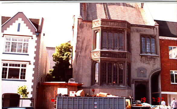
1969 California St
1969 California St,
San Francisco,
CA
94109
2 Weeks Ago
|
Edit
Favorites
1969 California St
Favorites
Highlights
- Walker's Paradise
- Fireplace
Pricing & Floor Plans
Check Back Soon for Upcoming Availability
Fees and Policies
Details
Property Information
-
Built in 1915
-
8 units/1 story
About 1969 California St San Francisco, CA 94109
At 1969 California St, find your new home. Make a visit to see the current floorplan options. The leasing staff is waiting to show you all that this community has in store. At 1969 California St, you'll have a wide selection of features and amenities like high-speed internet access, fireplaces, and smoke free options. Visit 1969 California St today.
1969 California St is an apartment community located in San Francisco County and the 94109 ZIP Code. This area is served by the San Francisco Unified attendance zone.
Apartment Features
- High Speed Internet Access
- Smoke Free
- Fireplace
Location
Get Directions
Lower Pacific Heights is a vibrant San Francisco neighborhood situated between Pacific Heights, Japantown, the Fillmore District, and Laurel Heights. Formerly known as Upper Fillmore, Lower Pacific Heights offers residents a wide variety of apartments, condos, and houses available for rent, many of which boast scenic views due to the neighborhood’s hilly environment.
Lower Pacific Heights is regarded for its walkable layout, with many rentals situated within easy walking distance of the diverse restaurants, shops, coffeehouses, and bars that line Fillmore Street, the community’s main commercial thoroughfare. The neighborhood’s central locale is a major part of its allure, providing quick access to Union Square, the University of San Francisco, the Financial District, several prominent medical centers, tech employers, landmarks, and more.
Learn more about living in Lower Pacific HeightsBelow are rent ranges for similar nearby apartments
Amenities
- High Speed Internet Access
- Smoke Free
- Fireplace
Education
| Colleges & Universities | Distance | ||
|---|---|---|---|
| Colleges & Universities | Distance | ||
| Walk: | 18 min | 0.9 mi | |
| Drive: | 3 min | 1.2 mi | |
| Drive: | 5 min | 1.9 mi | |
| Drive: | 5 min | 2.0 mi |
1969 California St is within 3 minutes or 1.2 miles from Academy of Art University. It is also near UC San Francisco, Mount Zion and Golden Gate Univ., San Fran..
Schools


Public Elementary School
Grades K-5
347 Students
Nearby
Public Elementary School
Grades K-5
287 Students
Attendance Zone
Public Elementary & Middle School
Grades K-8
536 Students
Nearby
Public Middle School
Grades 6-8
676 Students
Attendance Zone
Public High School
Grades 9-12
1,826 Students
Attendance Zone
Public High School
Grades 9-12
549 Students
Attendance Zone
Private Elementary, Middle & High School
Grades K-12
404 Students
Nearby
Private Elementary & Middle School
Grades PK-8
175 Students
Nearby
Private Elementary School
Grades K-1
38 Students
Nearby
Private High School
Grades 9-12
203 Students
Nearby
School data provided by
 The GreatSchools Rating helps parents compare schools within a state based on a variety of school quality indicators and provides a helpful picture of how effectively each school serves all of its students. Ratings are on a scale of 1 (below average) to 10 (above average) and can include test scores, college readiness, academic progress, advanced courses, equity, discipline and attendance data. We also advise parents to visit schools, consider other information on school performance and programs, and consider family needs as part of the school selection process.
View GreatSchools Rating Methodology
Data provided by GreatSchools.org © 2025. All rights reserved.
View GreatSchools Rating Methodology
Data provided by GreatSchools.org © 2025. All rights reserved.
Transportation options available in San Francisco include Van Ness And California, located 0.3 mile from 1969 California St. 1969 California St is near San Francisco International, located 14.6 miles or 25 minutes away, and Metro Oakland International, located 20.4 miles or 32 minutes away.
| Transit / Subway | Distance | ||
|---|---|---|---|
| Transit / Subway | Distance | ||
|
|
Walk: | 5 min | 0.3 mi |
|
|
Walk: | 8 min | 0.4 mi |
|
|
Walk: | 10 min | 0.5 mi |
|
|
Walk: | 13 min | 0.7 mi |
|
|
Walk: | 15 min | 0.8 mi |
| Commuter Rail | Distance | ||
|---|---|---|---|
| Commuter Rail | Distance | ||
| Drive: | 6 min | 2.4 mi | |
| Drive: | 7 min | 2.5 mi | |
| Drive: | 8 min | 3.9 mi | |
| Drive: | 9 min | 4.0 mi | |
| Drive: | 13 min | 6.7 mi |
| Airports | Distance | ||
|---|---|---|---|
| Airports | Distance | ||
|
San Francisco International
|
Drive: | 25 min | 14.6 mi |
|
Metro Oakland International
|
Drive: | 32 min | 20.4 mi |
Time and distance from 1969 California St.
| Shopping Centers | Distance | ||
|---|---|---|---|
| Shopping Centers | Distance | ||
| Walk: | 7 min | 0.4 mi | |
| Walk: | 10 min | 0.5 mi | |
| Drive: | 5 min | 1.4 mi |
1969 California St has 3 shopping centers within 1.4 miles, which is about a 5-minute drive. The miles and minutes will be for the farthest away property.
| Parks and Recreation | Distance | ||
|---|---|---|---|
| Parks and Recreation | Distance | ||
|
San Francisco Maritime National Historical Park
|
Drive: | 4 min | 1.7 mi |
|
Children's Creativity Museum
|
Drive: | 5 min | 1.8 mi |
|
Aquarium of The Bay
|
Drive: | 6 min | 2.3 mi |
|
Exploratorium
|
Drive: | 5 min | 2.3 mi |
|
Buena Vista Park
|
Drive: | 7 min | 2.3 mi |
1969 California St has 5 parks within 2.3 miles, including San Francisco Maritime National Historical Park, Children's Creativity Museum, and Exploratorium.
| Hospitals | Distance | ||
|---|---|---|---|
| Hospitals | Distance | ||
| Walk: | 10 min | 0.6 mi | |
| Walk: | 11 min | 0.6 mi | |
| Drive: | 4 min | 1.3 mi |
1969 California St has 3 hospitals within 1.3 miles, the nearest is California Pacific Medical Center - Van Ness Campus which is 0.6 mile away and a 10 minute walk.
| Military Bases | Distance | ||
|---|---|---|---|
| Military Bases | Distance | ||
| Drive: | 12 min | 4.3 mi | |
| Drive: | 13 min | 4.7 mi | |
| Drive: | 15 min | 6.5 mi |
1969 California St has 3 military bases within 6.5 miles, the nearest is East Fort Miley which is 4.3 miles away and a 12 minute drive.
You May Also Like
Does 1969 California St have in-unit laundry?
1969 California St does not offer in-unit laundry or shared facilities. Please contact the property to learn about nearby laundry options.
What utilities are included in rent at 1969 California St?
Utilities are not included in rent. Residents should plan to set up and pay for all services separately.
Is 1969 California St pet-friendly?
1969 California St does not allow pets, though service animals are always welcome in accordance with applicable laws.
Does 1969 California St have move-in specials?
1969 California St is not currently offering any rent specials. Check back soon, as promotions change frequently.
Does 1969 California St offer Matterport 3D tours?
While 1969 California St does not offer Matterport 3D tours, renters can request a tour directly through our online platform.
Similar Rentals Nearby


What Are Walk Score®, Transit Score®, and Bike Score® Ratings?
Walk Score® measures the walkability of any address. Transit Score® measures access to public transit. Bike Score® measures the bikeability of any address.
What is a Sound Score Rating?
A Sound Score Rating aggregates noise caused by vehicle traffic, airplane traffic and local sources
Property Manager Responded