
Baxter on Broadway
4901 Broadway,
Oakland, CA 94611
$2,208 - $3,370 Total Monthly Price
Studio - 3 Beds

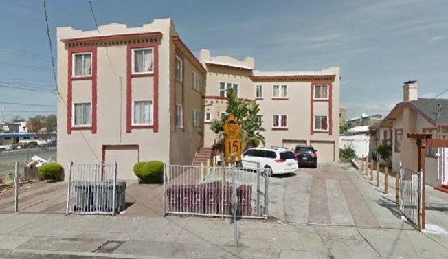
Experience Oakland living at 1921 36th Ave. Based in the 94601 Zip code of Oakland on 36th Ave, residents have access to a mixture of nearby attractions. Schedule a time to see the available floorplan options. Here at this community, the leasing staff is ready to match you with your perfect home. Stop by 1921 36th Ave today.
1921 36th Ave is an apartment community located in Alameda County and the 94601 ZIP Code. This area is served by the Oakland Unified School District attendance zone.
Mostly a residential neighborhood, Harrington is brimming with family housing and apartments in addition to local businesses. Harrington is located within close proximity to a number of parks, entertainment venues, and higher learning institutions.
Nearby Cesar Chavez Park, Allendale Recreation Center, and Redwood Regional Park offer ample opportunities for engaging in outdoor activities. Peralta Hacienda Historical Park, Oracle Arena, Chabot Space and Science Center, and Children’s Fairyland are not too far from Harrington for a day of adventure. Patten University, Mills College, Merritt College, Holy Names University, and Laney College are all convenient to commute to from Harrington.
With access to the I-580 and I-880, Fruitvale BART station, and Downtown Oakland, Harrington allows for simple commutes and travels. Both Oakland International and San Francisco International Airports are short drives from the neighborhood as well.
Learn more about living in HarringtonCompare neighborhood and city base rent averages by bedroom.
| Harrington | Oakland, CA | |
|---|---|---|
| Studio | $591 | $1,734 |
| 1 Bedroom | $1,799 | $2,140 |
| 2 Bedrooms | $1,445 | $2,723 |
| 3 Bedrooms | $2,199 | $3,290 |
| Colleges & Universities | Distance | ||
|---|---|---|---|
| Colleges & Universities | Distance | ||
| Drive: | 5 min | 2.9 mi | |
| Drive: | 8 min | 2.9 mi | |
| Drive: | 7 min | 3.6 mi | |
| Drive: | 11 min | 5.2 mi |


Transportation options available in Oakland include Fruitvale, located 0.6 mile from 1921 36th Ave. 1921 36th Ave is near Metro Oakland International, located 6.4 miles or 11 minutes away, and San Francisco International, located 26.6 miles or 39 minutes away.
| Transit / Subway | Distance | ||
|---|---|---|---|
| Transit / Subway | Distance | ||
|
|
Walk: | 12 min | 0.6 mi |
|
|
Drive: | 5 min | 2.7 mi |
|
|
Drive: | 6 min | 3.3 mi |
|
|
Drive: | 7 min | 3.7 mi |
|
|
Drive: | 7 min | 4.0 mi |
| Commuter Rail | Distance | ||
|---|---|---|---|
| Commuter Rail | Distance | ||
|
|
Drive: | 7 min | 4.2 mi |
| Drive: | 12 min | 7.6 mi | |
|
|
Drive: | 13 min | 9.2 mi |
|
|
Drive: | 16 min | 11.6 mi |
| Drive: | 21 min | 14.2 mi |
| Airports | Distance | ||
|---|---|---|---|
| Airports | Distance | ||
|
Metro Oakland International
|
Drive: | 11 min | 6.4 mi |
|
San Francisco International
|
Drive: | 39 min | 26.6 mi |
Scores provided by
Traffic
BusyAirport
CalmBusinesses
BusyScores provided by
HowLoud What is a Sound Score Rating? A Sound Score Rating aggregates noise caused by vehicle traffic, airplane traffic and local sources. How It WorksTime and distance from 1921 36th Ave.
| Shopping Centers | Distance | ||
|---|---|---|---|
| Shopping Centers | Distance | ||
| Walk: | 11 min | 0.6 mi | |
| Walk: | 12 min | 0.6 mi | |
| Walk: | 12 min | 0.6 mi |
| Parks and Recreation | Distance | ||
|---|---|---|---|
| Parks and Recreation | Distance | ||
|
Juan Bautista de Anza National Historic Trail
|
Drive: | 6 min | 3.3 mi |
|
Oakland Museum of California
|
Drive: | 6 min | 3.3 mi |
|
Lakeside Park
|
Drive: | 7 min | 4.0 mi |
|
Rotary Nature Center
|
Drive: | 8 min | 4.3 mi |
|
Lakeside Park Garden Center
|
Drive: | 7 min | 4.3 mi |
| Hospitals | Distance | ||
|---|---|---|---|
| Hospitals | Distance | ||
| Walk: | 18 min | 1.0 mi | |
| Drive: | 5 min | 2.4 mi | |
| Drive: | 7 min | 3.1 mi |
| Military Bases | Distance | ||
|---|---|---|---|
| Military Bases | Distance | ||
| Drive: | 15 min | 6.7 mi | |
| Drive: | 16 min | 7.7 mi |
What Are Walk Score®, Transit Score®, and Bike Score® Ratings?
Walk Score® measures the walkability of any address. Transit Score® measures access to public transit. Bike Score® measures the bikeability of any address.
What is a Sound Score Rating?
A Sound Score Rating aggregates noise caused by vehicle traffic, airplane traffic and local sources.
1921 36th Ave
Oakland, CA 94601


