

$5,700
Total Monthly Price
186 Kelton St
Boston, MA 02134
Today
|
Edit
Favorites
617-650-7636
-
Bedrooms
5
-
Bathrooms
2
-
Square Feet
1,650 sq ft
-
Available
Available Sep 1
186 Kelton St

Favorites
About This Home
Available Sep 1
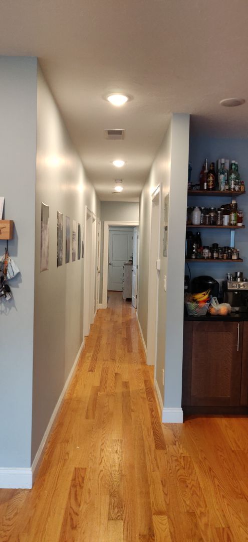
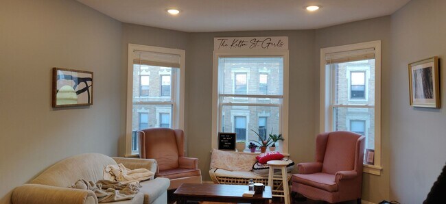
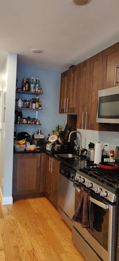
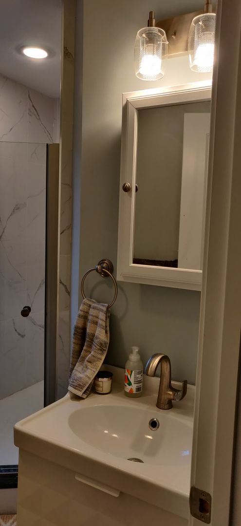
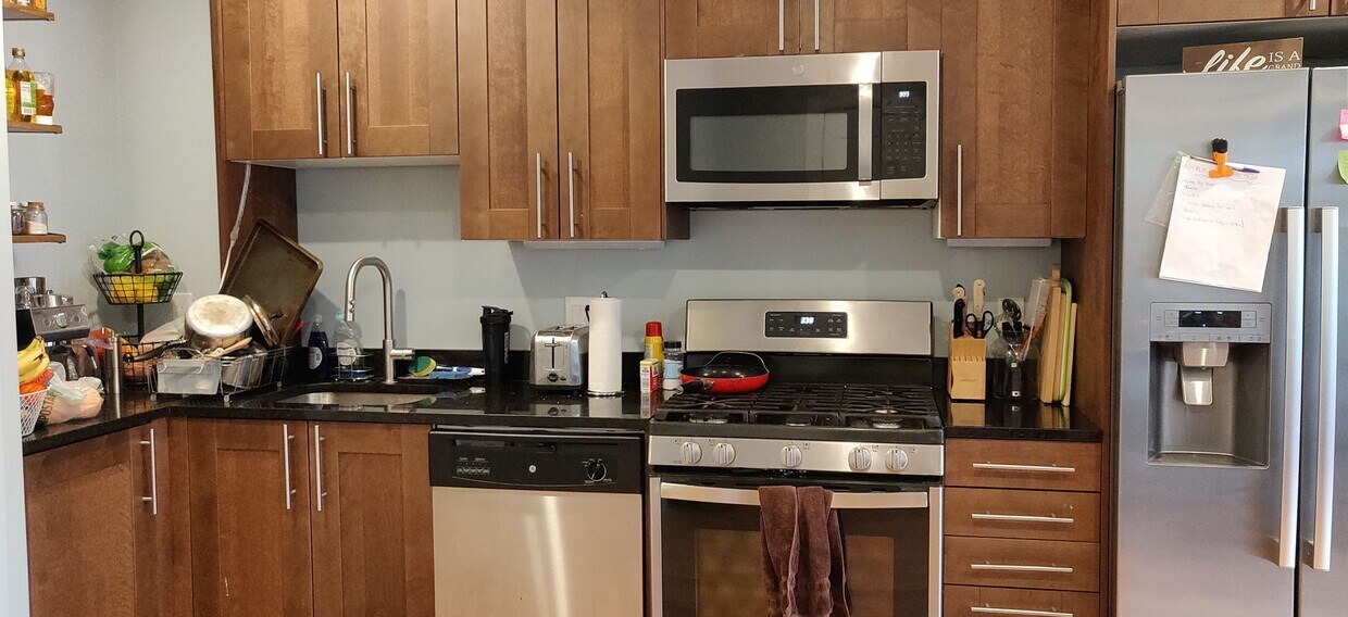
Available September 1 Recently Renovated Unit This is a three-story, townhouse-style unit. Newly refinished hardwood floors throughout. Granite/Stainless, eat-in kitchen has new floors, a dishwasher, and 2 refrigerators! Large living room and shared outdoor space. The bedrooms are spacious and sunny! Laundry in the basement. Convenient location close to B line, Stop and Shop, and St. Elizabeth's Hospital. A lot of storage space in the basement. Driveway parking is available for rent. PROPERTY INFO ID: 185116550 Rent: $5700 / Month Beds: 5 Bath: 2 Available Date: 09/01/2026 Parking:: off-street parking
186 Kelton St is a condo located in Suffolk County and the 02134 ZIP Code. This area is served by the Boston Public Schools attendance zone.
* Price shown is total price based on community-supplied monthly required fees. Excludes user-selected optional fees and variable or usage-based fees and required charges due at or prior to move-in or at move-out. Price, availability, fees, and any applicable rent special are subject to change without notice.
* Square footage definitions vary. Displayed square footage is approximate.
Contact
- Listed by Modern Real Estate (AD) | Modern Real Estate (AD)
- Phone Number
- Contact
Location
Get Directions
Situated about five miles west of Downtown Boston, Commonwealth boasts a vibrant atmosphere with charming brick buildings, local shops, delectable restaurants, numerous entertainment options, lush parks and playgrounds, and a diverse population. Commonwealth is convenient to several renowned attractions, including the John Fitzgerald Kennedy National Historic Site, Coolidge Corner Theatre, Brookline Booksmith, and Brighton Music Hall.
Commonwealth residents also enjoy quick access to Boston College, making the area especially popular among the institution’s students, faculty, and staff. A host of T stops strewn along Commonwealth Avenue provide easy commutes and travels to Greater Boston as well as convenience to an array of metropolitan amenities.
Learn more about living in Commonwealth
Education
| Colleges & Universities | Distance | ||
|---|---|---|---|
| Colleges & Universities | Distance | ||
| Drive: | 5 min | 1.6 mi | |
| Drive: | 6 min | 1.7 mi | |
| Drive: | 6 min | 2.1 mi | |
| Drive: | 7 min | 2.5 mi |
186 Kelton St is within 5 minutes or 1.6 miles from Boston University. It is also near Boston College, Brighton and Boston College.
Schools


Public Elementary & Middle School
Grades PK-8
352 Students
Attendance Zone
Public Middle & High School
Grades 7-12
609 Students
Attendance Zone
Public Middle & High School
Grades 7-12
2,382 Students
Attendance Zone
Charter Middle & High School
Grades 6-12
450 Students
Attendance Zone
Public High School
Grades 9-12
27 Students
Attendance Zone
Private Elementary & Middle School
Grades PK-8
263 Students
Nearby
Private Middle & High School
Grades 7-12
9 Students
Nearby
Private High School
Grades 9-12
210 Students
Nearby
School data provided by
 The GreatSchools Rating helps parents compare schools within a state based on a variety of school quality indicators and provides a helpful picture of how effectively each school serves all of its students. Ratings are on a scale of 1 (below average) to 10 (above average) and can include test scores, college readiness, academic progress, advanced courses, equity, discipline and attendance data. We also advise parents to visit schools, consider other information on school performance and programs, and consider family needs as part of the school selection process.
View GreatSchools Rating Methodology
Data provided by GreatSchools.org © 2026. All rights reserved.
View GreatSchools Rating Methodology
Data provided by GreatSchools.org © 2026. All rights reserved.
Transportation options available in Boston include Allston Street Station, located 0.1 mile from 186 Kelton St. 186 Kelton St is near General Edward Lawrence Logan International, located 8.7 miles or 16 minutes away.
| Transit / Subway | Distance | ||
|---|---|---|---|
| Transit / Subway | Distance | ||
|
|
Walk: | 2 min | 0.1 mi |
|
|
Walk: | 2 min | 0.1 mi |
|
|
Walk: | 5 min | 0.3 mi |
|
|
Walk: | 8 min | 0.4 mi |
|
|
Walk: | 8 min | 0.5 mi |
| Commuter Rail | Distance | ||
|---|---|---|---|
| Commuter Rail | Distance | ||
|
|
Drive: | 6 min | 2.8 mi |
|
|
Drive: | 9 min | 3.3 mi |
|
|
Drive: | 11 min | 3.7 mi |
|
|
Drive: | 12 min | 4.6 mi |
| Drive: | 10 min | 4.6 mi |
| Airports | Distance | ||
|---|---|---|---|
| Airports | Distance | ||
|
General Edward Lawrence Logan International
|
Drive: | 16 min | 8.7 mi |
Time and distance from 186 Kelton St.
| Shopping Centers | Distance | ||
|---|---|---|---|
| Shopping Centers | Distance | ||
| Walk: | 8 min | 0.5 mi | |
| Walk: | 14 min | 0.8 mi | |
| Walk: | 15 min | 0.8 mi |
186 Kelton St has 3 shopping centers within 0.8 mile, which is about a 15-minute walk. The miles and minutes will be for the farthest away property.
| Parks and Recreation | Distance | ||
|---|---|---|---|
| Parks and Recreation | Distance | ||
|
John Fitzgerald Kennedy National Historic Site
|
Walk: | 16 min | 0.9 mi |
|
Chestnut Hill Reservation
|
Drive: | 4 min | 1.3 mi |
|
Frederick Law Olmsted National Historic Site
|
Drive: | 6 min | 2.0 mi |
|
Coit Observatory
|
Drive: | 6 min | 2.1 mi |
|
Charles River Reservation
|
Drive: | 8 min | 3.3 mi |
186 Kelton St has 5 parks within 3.3 miles, including John Fitzgerald Kennedy National Historic Site, Chestnut Hill Reservation, and Coit Observatory.
| Hospitals | Distance | ||
|---|---|---|---|
| Hospitals | Distance | ||
| Walk: | 7 min | 0.4 mi | |
| Walk: | 11 min | 0.6 mi | |
| Walk: | 20 min | 1.0 mi |
186 Kelton St has 3 hospitals within 1.0 miles, the nearest is Franciscan Children's Hospital & Rehab Center which is 0.4 mile away and a 7 minute walk.
| Military Bases | Distance | ||
|---|---|---|---|
| Military Bases | Distance | ||
| Drive: | 28 min | 13.1 mi | |
| Drive: | 26 min | 13.9 mi |
186 Kelton St is 13.1 miles from Hanscom Air Force Base, and is convenient to other military bases, including US Military Reservation.
You May Also Like
-
Room in Shared 4 bed/1.5 bath home
17 Kenneson Rd
Somerville, MA 02145
$880 Plus Fees
4 Br 3.8 mi
-
31-33 Raymond Ave. Unit 33-2
31-33 Raymond Ave
Somerville, MA 02144
$5,200 Plus Fees
4 Br 12 Month Lease 4.1 mi
-
31-33 Raymond Ave. Unit 33-2
31-33 Raymond Ave
Somerville, MA 02144
$5,500 Plus Fees
4 Br 12 Month Lease 4.1 mi
Similar Rentals Nearby


What Are Walk Score®, Transit Score®, and Bike Score® Ratings?
Walk Score® measures the walkability of any address. Transit Score® measures access to public transit. Bike Score® measures the bikeability of any address.
What is a Sound Score Rating?
A Sound Score Rating aggregates noise caused by vehicle traffic, airplane traffic and local sources
186 Kelton St
Boston, MA 02134