

$2,000
/ Month
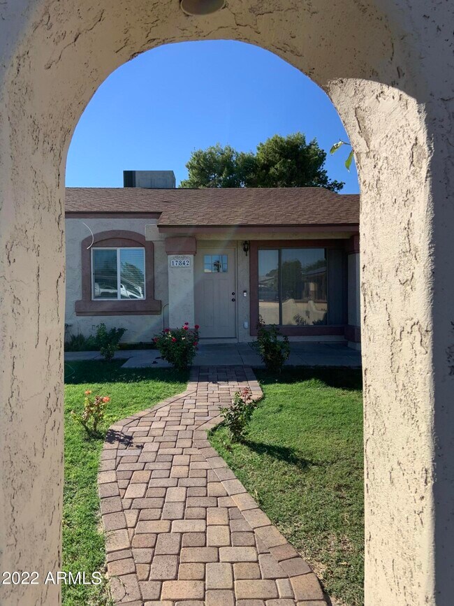
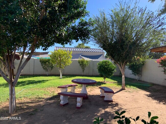
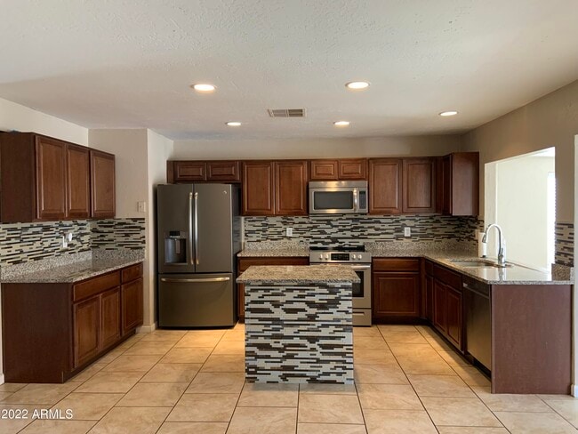
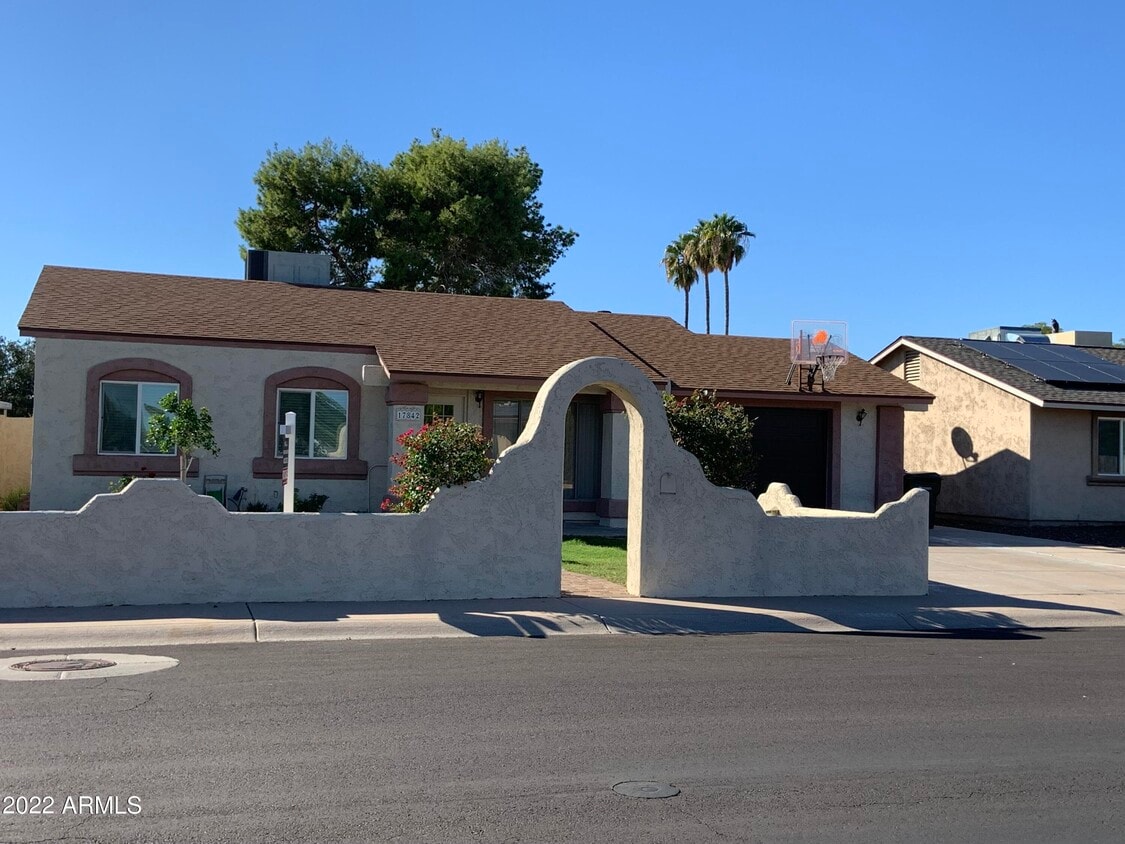
17842 N 33rd Ave
Phoenix, AZ 85053
2 Weeks Ago
|
Edit
Favorites
17842 N 33rd Ave

Favorites
Check Back Soon for Upcoming Availability
| Beds | Baths | Average SF |
|---|---|---|
| 4 Bedrooms 4 Bedrooms 4 Br | 2 Baths 2 Baths 2 Ba | — |
About This Property
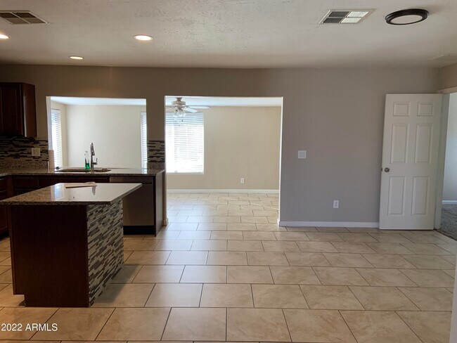
Beautiful updated home w/lush rose garden courtyard entry & park like backyard! Stagger set neutral tile in the living & high traffic areas. Large open kitchen w/stylish tile backsplash & island accent. Lots of upgraded cabinets, expansive granite countertops, + stainless steel appliances & passthrough window from the kitchen to the bonus room. Large addition at back of the house, perfect for 2nd living room, crafts, den, office, or kids' space! Updated hall bath w/pedestal sink & framed mirror, and renovated master bath with newer vanity, framed mirror, & custom shower. Plush carpeting & ceiling fans/lights in bedrooms. Backyard features numerous fruit & shade trees, seating area, large shed w/covered patio. Multiple driveway parking spaces, plus oversized 1.5 car garage & utility room
17842 N 33rd Ave is a house located in Maricopa County and the 85053 ZIP Code. This area is served by the Deer Valley Unified District attendance zone.
Location
Get Directions
Deer Valley is a family-friendly suburb and residential neighborhood that’s constantly evolving. There are abundant outdoor recreational opportunities in Deer Valley because of its proximity to several natural attractions like Deem Hills and Cave Buttes, both known for scenic hiking and mountain biking trails. Residents have easy access to abundant shopping opportunities without having to leave town at places like Deer Valley Towne Center and Bell Towne Plaza. Deer Valley is home to good public schools and is the ideal suburb for those commuting to Downtown Phoenix and beyond, located less than 20 miles south of town along Interstate 17.
Learn more about living in Deer ValleyBelow are rent ranges for similar nearby apartments
Education
| Colleges & Universities | Distance | ||
|---|---|---|---|
| Colleges & Universities | Distance | ||
| Drive: | 10 min | 4.2 mi | |
| Drive: | 10 min | 4.8 mi | |
| Drive: | 12 min | 5.4 mi | |
| Drive: | 15 min | 7.8 mi |
17842 N 33rd Ave is within 10 minutes or 4.2 miles from Midwestern University. It is also near Arizona State University, West and Thunderbird, West Campus.
Schools


Public Elementary School
Grades PK-6
475 Students
Attendance Zone
Public Middle & High School
Grades 7-12
1,637 Students
Attendance Zone
Public Middle School
Grades 7-8
648 Students
Attendance Zone
Private Elementary, Middle & High School
Grades PK-12
1,468 Students
Nearby
Private Elementary, Middle & High School
Grades K-12
177 Students
Nearby
School data provided by
 The GreatSchools Rating helps parents compare schools within a state based on a variety of school quality indicators and provides a helpful picture of how effectively each school serves all of its students. Ratings are on a scale of 1 (below average) to 10 (above average) and can include test scores, college readiness, academic progress, advanced courses, equity, discipline and attendance data. We also advise parents to visit schools, consider other information on school performance and programs, and consider family needs as part of the school selection process.
View GreatSchools Rating Methodology
Data provided by GreatSchools.org © 2025. All rights reserved.
View GreatSchools Rating Methodology
Data provided by GreatSchools.org © 2025. All rights reserved.
Transportation options available in Phoenix include Metro Pkwy, located 5.8 miles from 17842 N 33rd Ave. 17842 N 33rd Ave is near Phoenix Sky Harbor International, located 21.8 miles or 32 minutes away.
| Transit / Subway | Distance | ||
|---|---|---|---|
| Transit / Subway | Distance | ||
|
|
Drive: | 9 min | 5.8 mi |
|
|
Drive: | 10 min | 6.1 mi |
|
|
Drive: | 11 min | 7.0 mi |
|
|
Drive: | 12 min | 7.5 mi |
|
|
Drive: | 13 min | 8.5 mi |
| Airports | Distance | ||
|---|---|---|---|
| Airports | Distance | ||
|
Phoenix Sky Harbor International
|
Drive: | 32 min | 21.8 mi |
Time and distance from 17842 N 33rd Ave.
| Shopping Centers | Distance | ||
|---|---|---|---|
| Shopping Centers | Distance | ||
| Walk: | 11 min | 0.6 mi | |
| Walk: | 12 min | 0.6 mi | |
| Walk: | 13 min | 0.7 mi |
17842 N 33rd Ave has 3 shopping centers within 0.7 mile, which is about a 13-minute walk. The miles and minutes will be for the farthest away property.
| Parks and Recreation | Distance | ||
|---|---|---|---|
| Parks and Recreation | Distance | ||
|
Conocido Park
|
Drive: | 3 min | 1.2 mi |
|
Acoma Park
|
Drive: | 6 min | 2.9 mi |
|
Adobe Mountain Park
|
Drive: | 7 min | 3.2 mi |
|
Paseo Highlands Park
|
Drive: | 7 min | 3.9 mi |
|
Adobe Dam Regional Park
|
Drive: | 9 min | 4.7 mi |
17842 N 33rd Ave has 5 parks within 4.7 miles, including Conocido Park, Acoma Park, and Adobe Mountain Park.
| Hospitals | Distance | ||
|---|---|---|---|
| Hospitals | Distance | ||
| Drive: | 5 min | 2.4 mi | |
| Drive: | 7 min | 3.5 mi | |
| Drive: | 9 min | 4.8 mi |
17842 N 33rd Ave has 3 hospitals within 4.8 miles, the nearest is Honorhealth Deer Valley Medical Center which is 2.4 miles away and a 5 minute drive.
| Military Bases | Distance | ||
|---|---|---|---|
| Military Bases | Distance | ||
| Drive: | 30 min | 21.4 mi | |
| Drive: | 32 min | 21.7 mi | |
| Drive: | 110 min | 84.5 mi |
17842 N 33rd Ave has 3 military bases within 84.5 miles, the nearest is Luke Air Force Base which is 21.4 miles away and a 30 minute drive.
You May Also Like
Similar Rentals Nearby


What Are Walk Score®, Transit Score®, and Bike Score® Ratings?
Walk Score® measures the walkability of any address. Transit Score® measures access to public transit. Bike Score® measures the bikeability of any address.
What is a Sound Score Rating?
A Sound Score Rating aggregates noise caused by vehicle traffic, airplane traffic and local sources
17842 N 33rd Ave
Phoenix, AZ 85053