

$3,300 / Month
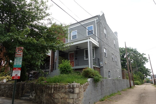
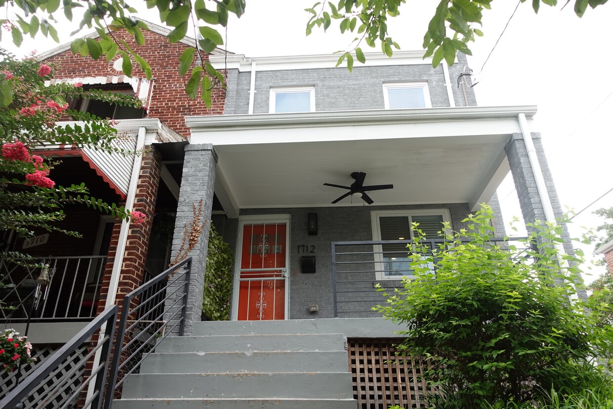
1712 Fort Davis St SE
Washington, DC 20020
Today
Favorites
202-851-8865
-
Bedrooms
3
-
Bathrooms
3.5
-
Square Feet
1,536 sq ft
-
Available
Available Now
1712 Fort Davis St SE

Favorites
About This Home
Available Now
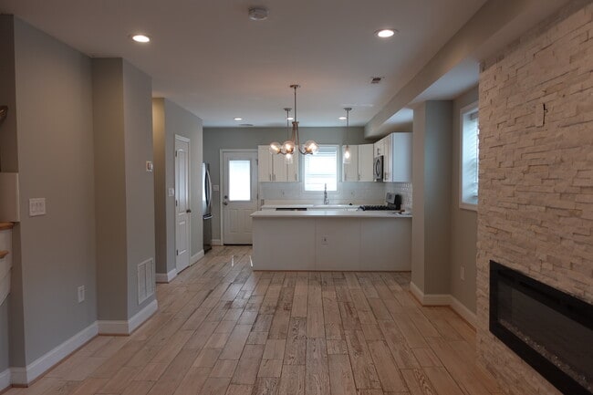
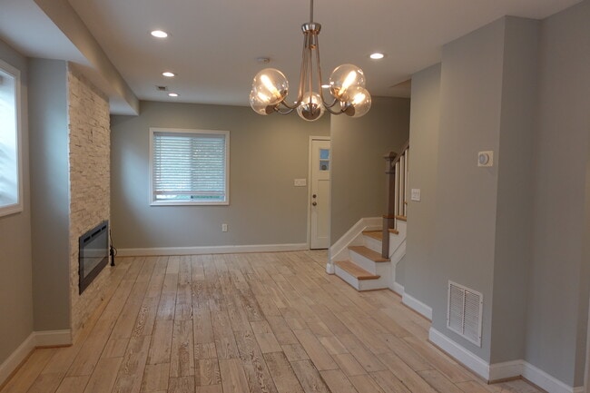
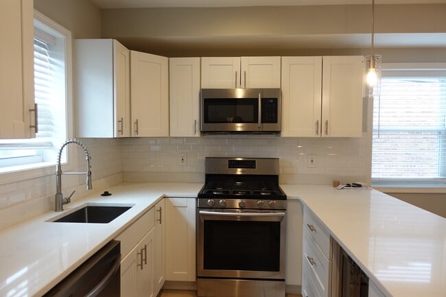
This spacious 3-bedroom, 3.5-bath home offers an open and functional floor plan, featuring a built-in electric fireplace set against a white natural stone accent wall. The kitchen is complete with white shaker-style cabinets, white quartz countertops, Samsung stainless steel appliances, a built-in microwave, and a dual-zoned wine cooler. There are two generously sized en-suite bedrooms on the upper level. A linen closet and in-unit washer/dryer add extra convenience to the upper level. The fully finished lower level features a bedroom, full bathroom, kitchenette, and its own washer/dryer. Outside, enjoy your own private oasis with a rear deck and lower patio. Located on a quiet corner just minutes from Skyland Town Center, Fort Dupont Park, and convenient Metro access to the Orange, Blue, and Green lines.
1712 Fort Davis St SE is a house located in District of Columbia County and the 20020 ZIP Code. This area is served by the District Of Columbia Public Schools attendance zone.
* Price shown is base rent and may not include non-optional fees and utilities.
Price, availability, fees, and any applicable rent special are subject to change without notice.
* Square footage definitions vary. Displayed square footage is approximate.
House Features
- Washer/Dryer
- Fireplace
- Hardwood Floors
- Fenced Lot
Fees and Policies
The fees below are based on community-supplied data and may exclude additional fees and utilities.
- Dogs Allowed
-
Fees not specified
- Cats Allowed
-
Fees not specified
Contact
- Listed by Daniel Walcott
- Phone Number
- Contact
Location
Get Directions
Amenities
- Washer/Dryer
- Fireplace
- Hardwood Floors
- Fenced Lot
The residential neighborhood of Fort Dupont sits just east of the Anacostia River in Southeast Washington, DC. The neighborhood has ample green space provided by two adjacent parks — Fort Circle Park and Fort Chaplin Park — and distinguishes itself within the Greater Anacostia area by housing the only public indoor ice rink in Washington, DC.
There’s a diverse mix of rentals in Fort Dupont, from more recent and upscale developments to long-standing apartment homes closer to the Anacostia River. Proximity to the Benning Road Metro Station makes Fort Dupont perfect for the Capitol Hill commuter who wishes to reside outside the bustle of DC.
Learn more about living in Fort Dupont
Education
| Colleges & Universities | Distance | ||
|---|---|---|---|
| Colleges & Universities | Distance | ||
| Drive: | 10 min | 4.9 mi | |
| Drive: | 10 min | 4.9 mi | |
| Drive: | 12 min | 5.6 mi | |
| Drive: | 11 min | 5.6 mi |
1712 Fort Davis St SE is within 10 minutes or 4.9 miles from Georgetown Law. It is also near Georgetown and Gallaudet University.
Schools


Public Elementary School
Grades PK-5
372 Students
Attendance Zone
Public Middle School
Grades 6-8
215 Students
Attendance Zone
Public High School
Grades 9-12
287 Students
Attendance Zone
Private Elementary & Middle School
Grades PK-8
130 Students
Nearby
Private Elementary, Middle & High School
Grades PK-12
149 Students
Nearby
School data provided by
 The GreatSchools Rating helps parents compare schools within a state based on a variety of school quality indicators and provides a helpful picture of how effectively each school serves all of its students. Ratings are on a scale of 1 (below average) to 10 (above average) and can include test scores, college readiness, academic progress, advanced courses, equity, discipline and attendance data. We also advise parents to visit schools, consider other information on school performance and programs, and consider family needs as part of the school selection process.
View GreatSchools Rating Methodology
Data provided by GreatSchools.org © 2025. All rights reserved.
View GreatSchools Rating Methodology
Data provided by GreatSchools.org © 2025. All rights reserved.
Transportation options available in Washington include Naylor Road, located 1.5 miles from 1712 Fort Davis St SE. 1712 Fort Davis St SE is near Ronald Reagan Washington Ntl, located 8.5 miles or 17 minutes away, and Baltimore/Washington International Thurgood Marshall, located 30.6 miles or 46 minutes away.
| Transit / Subway | Distance | ||
|---|---|---|---|
| Transit / Subway | Distance | ||
|
|
Drive: | 4 min | 1.5 mi |
|
|
Drive: | 5 min | 2.4 mi |
|
|
Drive: | 7 min | 2.7 mi |
|
|
Drive: | 8 min | 2.8 mi |
|
|
Drive: | 9 min | 3.0 mi |
| Commuter Rail | Distance | ||
|---|---|---|---|
| Commuter Rail | Distance | ||
|
|
Drive: | 12 min | 4.4 mi |
|
|
Drive: | 9 min | 4.5 mi |
|
|
Drive: | 10 min | 4.5 mi |
|
|
Drive: | 10 min | 5.8 mi |
|
|
Drive: | 14 min | 7.2 mi |
| Airports | Distance | ||
|---|---|---|---|
| Airports | Distance | ||
|
Ronald Reagan Washington Ntl
|
Drive: | 17 min | 8.5 mi |
|
Baltimore/Washington International Thurgood Marshall
|
Drive: | 46 min | 30.6 mi |
Time and distance from 1712 Fort Davis St SE.
| Shopping Centers | Distance | ||
|---|---|---|---|
| Shopping Centers | Distance | ||
| Walk: | 2 min | 0.1 mi | |
| Walk: | 5 min | 0.3 mi | |
| Walk: | 35 min | 1.8 mi |
1712 Fort Davis St SE has 3 shopping centers within 1.8 miles, which is about a 35-minute walk. The miles and minutes will be for the farthest away property.
| Parks and Recreation | Distance | ||
|---|---|---|---|
| Parks and Recreation | Distance | ||
|
Fort Dupont Park
|
Drive: | 4 min | 1.3 mi |
|
Frederick Douglass National Historic Site
|
Drive: | 8 min | 2.6 mi |
|
Oxon Cove Park
|
Drive: | 7 min | 2.9 mi |
|
Kenilworth Park & Aquatic Gardens
|
Drive: | 7 min | 2.9 mi |
|
Kingman and Heritage Island Park
|
Drive: | 7 min | 3.8 mi |
1712 Fort Davis St SE has 5 parks within 3.8 miles, including Fort Dupont Park, Frederick Douglass National Historic Site, and Oxon Cove Park.
| Hospitals | Distance | ||
|---|---|---|---|
| Hospitals | Distance | ||
| Drive: | 9 min | 3.1 mi | |
| Drive: | 9 min | 3.6 mi | |
| Drive: | 14 min | 7.0 mi |
1712 Fort Davis St SE has 3 hospitals within 7.0 miles, the nearest is St. Elizabeth's Hospital which is 3.1 miles away and a 9 minute drive.
| Military Bases | Distance | ||
|---|---|---|---|
| Military Bases | Distance | ||
| Drive: | 8 min | 3.3 mi | |
| Drive: | 10 min | 4.1 mi |
1712 Fort Davis St SE is 3.3 miles from Washington Navy Yard, and is convenient to other military bases, including Anacostia Naval Station.
You May Also Like
Similar Rentals Nearby


What Are Walk Score®, Transit Score®, and Bike Score® Ratings?
Walk Score® measures the walkability of any address. Transit Score® measures access to public transit. Bike Score® measures the bikeability of any address.
What is a Sound Score Rating?
A Sound Score Rating aggregates noise caused by vehicle traffic, airplane traffic and local sources
1712 Fort Davis St SE
Washington, DC 20020