

$1,500
/ Month
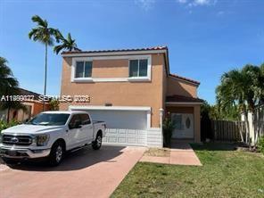
16870 SW 142nd Pl Unit 1
Miami, FL 33177
Today
|
Edit
Favorites
786-609-0335
-
Bedrooms
1
-
Bathrooms
1
-
Square Feet
1,593 sq ft
-
Available
Available Apr 1
Highlights
- 1 Car Garage
- 1-Story Property
16870 SW 142nd Pl Unit 1

Favorites
About This Home
Available Apr 1
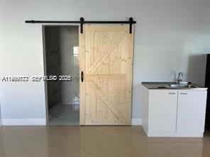
Beautiful, completely remodeled efficiency available now! Perfect for a single person or a couple looking for a private, comfortable space. Private entrance, patio area, Fully remodeled, Full bathroom, Kitchen / kitchenette. ALL utilities included (water, electricity, WiFi) Quiet and safe area MLS # A11989072
16870 Sw 142Nd Pl is an apartment community located in Miami/Dade County and the 33177 ZIP Code.
* Price shown is base rent. Excludes user-selected optional fees and variable or usage-based fees and required charges due at or prior to move-in or at move-out. Price, availability, fees, and any applicable rent special are subject to change without notice.
* Square footage definitions vary. Displayed square footage is approximate.
Home Details
Year Built
Built in 1994
Bedrooms and Bathrooms
1 Full Bathroom
1 Bedroom
Home Design
Entry on the 1st floor
Interior Spaces
1,593 Sq Ft Home
1-Story Property
Listing and Financial Details
Property Available on 4/1/26
Assessor Parcel Number 30-59-34-008-0550
Lot Details
4,304 Sq Ft Lot
Property is zoned 3800
Parking
1 Car Garage
Schools
Miami Heights Elementary School
Jorge Mas Canosa Middle School
South Dade High School
Community Details
Overview
No Home Owners Association
Weitzer Serena Lakes West Condos
Weitzer Serena Lakes West Subdivision
Pet Policy
No Pets Allowed
Fees and Policies
The fees listed below are community-provided and may exclude utilities or add-ons. All payments are made directly to the property and are non-refundable unless otherwise specified. Use the Cost Calculator to determine costs based on your needs.
-
One-Time Basics
-
Due at Application
-
Application Fee Per ApplicantCharged per applicant.$50
-
-
Due at Application
Property Fee Disclaimer: Based on community-supplied data and independent market research. Subject to change without notice. May exclude fees for mandatory or optional services and usage-based utilities.
Contact
- Listed by Osmany Linares | Inmobi Realestate & Associates, LLC.
- Phone Number
- Contact
-
Source
 MIAMI Association of REALTORS®
Copyright © 2026 MIAMI Association of REALTORS®. All rights reserved. All information provided by the listing agent/broker is deemed reliable but is not guaranteed and should be independently verified.
Location
Get Directions
Richmond West is a small residential community about 10 miles from the Atlantic Coast and 20 miles southwest of Miami. The neighborhood is conveniently placed a few minutes south of the Miami Executive Airport, and it borders Larry and Penny Thompson Memorial Park, home to Zoo Miami. Within Richmond West’s bounds, residential areas with a variety of rental choices dominate the neighborhood while community parks and ponds, like Chuck Pezoldt Park, dot the area. For shopping and dining close to home, residents can journey to the corners of the neighborhood. A shopping plaza sits at the Highway 825 and 152nd Street intersection.
Learn more about living in Richmond West
Education
| Colleges & Universities | Distance | ||
|---|---|---|---|
| Colleges & Universities | Distance | ||
| Drive: | 19 min | 8.9 mi | |
| Drive: | 26 min | 11.8 mi | |
| Drive: | 27 min | 16.5 mi | |
| Drive: | 28 min | 16.7 mi |
16870 SW 142nd Pl Unit 1 is within 19 minutes or 8.9 miles from Miami Dade College, Kendall. It is also near Miami Dade College, Homestead and FIU, Modesto Maidique.
Getting Around
 What do Walkability, Transit, Drivability, and Bikeability mean?
Walkability measures the walking distance to day-to-day needs.
Transit measures access to public transportation.
Drivability measures congestion, parking availability, and access to major roads.
Bikeability measures the suitability for cycling.
How It Works
What do Walkability, Transit, Drivability, and Bikeability mean?
Walkability measures the walking distance to day-to-day needs.
Transit measures access to public transportation.
Drivability measures congestion, parking availability, and access to major roads.
Bikeability measures the suitability for cycling.
How It Works
Somewhat Walkable
Walkability
30
/ 100
Minimal Public Transit
Transit
0
/ 100
Very Drivable
Drivability
80
/ 100
Fairly Bikeable
Bikeability
50
/ 100
Scores provided by
-
Soundscore™
-
/ 100
Traffic
-Airport
-Businesses
-Scores provided by
HowLoud What is a Sound Score Rating? A Sound Score Rating aggregates noise caused by vehicle traffic, airplane traffic and local sources. How It WorksYou May Also Like
Similar Rentals Nearby
-
-
1 Bed$2,473+2 Beds$3,681+3 Beds$4,699+Total Monthly PriceTotal Monthly Price NewPrices include base rent and required monthly fees of $103. Variable costs based on usage may apply.Base Rent:1 Bed$2,370+2 Beds$3,578+3 Beds$4,596+1 Month Free
Pets Allowed Fitness Center Pool Kitchen Grill EV Charging
-
1 Bed$2,195+2 Beds$2,647+3 Beds$3,209+Total Monthly PriceTotal Monthly Price NewPrices include all required monthly fees.
Pets Allowed Fitness Center Pool Dishwasher Refrigerator Clubhouse
-
-
-
1 / 8
 1 Bed$3,055+2 Beds$4,870+3 Beds$7,223+Total Monthly PriceTotal Monthly Price NewPrices include required monthly fees of $130.Base Rent:1 Bed$2,925+2 Beds$4,740+3 Beds$7,093+
Pets Allowed Dishwasher Balcony Patio Elevator
-
-
1 Bed$2,8002 Beds$3,500+Total Monthly PriceTotal Monthly Price NewPrices include all required monthly fees.
Pets Allowed Fitness Center Pool Clubhouse Business Center Controlled Access Elevator
-
-


What Are Walk Score®, Transit Score®, and Bike Score® Ratings?
Walk Score® measures the walkability of any address. Transit Score® measures access to public transit. Bike Score® measures the bikeability of any address.
What is a Sound Score Rating?
A Sound Score Rating aggregates noise caused by vehicle traffic, airplane traffic and local sources.
16870 SW 142nd Pl
Miami, FL 33177