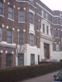
1669 Commonwealth Ave Unit 11
Boston, MA 02135
Check Back Soon for Upcoming Availability
| Beds | Baths | Average SF |
|---|---|---|
| Studio Studio 0 Br | 1 Bath 1 Bath 1 Ba | 9,999 SF |
About This Property
Located in the heart of sought after Brighton just minutes from shopping, dining, bars, nightlife, and much more! Awesome commuting location very close to Green Line B train to BC and Government Center! Convenient to the Green Line C & D trains, as well as many major MBTA bus routes. Very close to Boston College campus! Easy access by bus, bike, train, or foot to attractions such as St. Elizabeth's Medical Center, Chestnut Hill, Boston University, Cleveland Circle, Newton Center, Longwood Medical, Oak Square, Packard's Corner, Washington Square, Coolidge Corner, and more! Lovely area with public parks, country clubs, golf courses, reservoirs, ponds, and conservation areas close by! A great location to call home in beautiful Brighton!
1669 Commonwealth Ave is a condo located in Suffolk County and the 02135 ZIP Code.
Saint Elizabeth’s is a Brighton neighborhood situated about 10 miles away from Boston. Thanks to Saint Elizabeth’s top border sitting on Highway 20, commuting in and out of Brighton is easy. Some residents travel by car, but buses and railways make commuting via public transportation a breeze.
The neighborhood’s best amenities are two world-renowned hospitals, Saint Elizabeth’s Medical Center and Franciscan Children’s, that sit on the edge of town. Other great amenities of Saint Elizabeth’s include many local parks like Ringer Playground and Chestnut Hill Reservoir, which has great trails and greenspace. This neighborhood is also equipped with cozy coffee shops, restaurants serving international and American classics, and shopping plazas with grocers and convenience stores.
Saint Elizabeth’s has several rental options ranging from apartments to single-family homes.
Learn more about living in St Elizabeth'sBelow are rent ranges for similar nearby apartments
| Beds | Average Size | Lowest | Typical | Premium |
|---|---|---|---|---|
| Studio Studio Studio | 4188 Sq Ft | $1,725 | $2,303 | $5,650 |
| 1 Bed 1 Bed 1 Bed | 3384-3385 Sq Ft | $100 | $2,596 | $10,000 |
| 2 Beds 2 Beds 2 Beds | 3086-3088 Sq Ft | $1,630 | $3,200 | $5,290 |
| 3 Beds 3 Beds 3 Beds | 3760-3761 Sq Ft | $2,500 | $3,914 | $6,682 |
| 4 Beds 4 Beds 4 Beds | 3351 Sq Ft | $780 | $5,319 | $14,300 |
| Colleges & Universities | Distance | ||
|---|---|---|---|
| Colleges & Universities | Distance | ||
| Drive: | 4 min | 1.4 mi | |
| Drive: | 3 min | 1.5 mi | |
| Drive: | 5 min | 2.4 mi | |
| Drive: | 7 min | 3.0 mi |
Transportation options available in Boston include Sutherland Street Station, located 0.2 mile from 1669 Commonwealth Ave Unit 11. 1669 Commonwealth Ave Unit 11 is near General Edward Lawrence Logan International, located 9.6 miles or 17 minutes away.
| Transit / Subway | Distance | ||
|---|---|---|---|
| Transit / Subway | Distance | ||
|
|
Walk: | 3 min | 0.2 mi |
|
|
Walk: | 4 min | 0.2 mi |
|
|
Walk: | 8 min | 0.4 mi |
|
|
Walk: | 11 min | 0.6 mi |
|
|
Walk: | 12 min | 0.7 mi |
| Commuter Rail | Distance | ||
|---|---|---|---|
| Commuter Rail | Distance | ||
|
|
Drive: | 7 min | 3.7 mi |
|
|
Drive: | 8 min | 3.8 mi |
|
|
Drive: | 8 min | 3.8 mi |
| Drive: | 9 min | 4.6 mi | |
|
|
Drive: | 10 min | 5.1 mi |
| Airports | Distance | ||
|---|---|---|---|
| Airports | Distance | ||
|
General Edward Lawrence Logan International
|
Drive: | 17 min | 9.6 mi |
Time and distance from 1669 Commonwealth Ave Unit 11.
| Shopping Centers | Distance | ||
|---|---|---|---|
| Shopping Centers | Distance | ||
| Walk: | 7 min | 0.4 mi | |
| Walk: | 13 min | 0.7 mi | |
| Drive: | 5 min | 1.6 mi |
| Parks and Recreation | Distance | ||
|---|---|---|---|
| Parks and Recreation | Distance | ||
|
Chestnut Hill Reservation
|
Walk: | 13 min | 0.7 mi |
|
John Fitzgerald Kennedy National Historic Site
|
Drive: | 4 min | 1.8 mi |
|
Frederick Law Olmsted National Historic Site
|
Drive: | 5 min | 2.3 mi |
|
Hammond Pond Reservation
|
Drive: | 5 min | 2.6 mi |
|
Coit Observatory
|
Drive: | 6 min | 2.9 mi |
| Hospitals | Distance | ||
|---|---|---|---|
| Hospitals | Distance | ||
| Walk: | 13 min | 0.7 mi | |
| Walk: | 16 min | 0.8 mi | |
| Drive: | 3 min | 1.9 mi |
| Military Bases | Distance | ||
|---|---|---|---|
| Military Bases | Distance | ||
| Drive: | 28 min | 12.9 mi | |
| Drive: | 23 min | 13.3 mi |
You May Also Like
Similar Rentals Nearby
-
1 Bed$2,725Total Monthly PriceTotal Monthly Price NewPrices include required monthly fees of $375.Base Rent:1 Bed$2,350Apartment for Rent
-
-
-
2 Beds$3,270Total Monthly PriceTotal Monthly Price NewPrices include required monthly fees of $440.Base Rent:2 Beds$2,830Apartment for Rent
-
1 Bed$2,585Total Monthly PriceTotal Monthly Price NewPrices include required monthly fees of $375.Base Rent:1 Bed$2,210Apartment for Rent
-
-
1 Bed$2,665Total Monthly PriceTotal Monthly Price NewPrices include required monthly fees of $375.Base Rent:1 Bed$2,290Apartment for Rent
-
1 Bed$2,225Total Monthly PriceTotal Monthly Price NewPrices include required monthly fees of $355.Base Rent:1 Bed$1,870Apartment for Rent
-
-
2 Beds$2,425Total Monthly PriceTotal Monthly Price NewPrices include required monthly fees of $415.Base Rent:2 Beds$2,010Apartment for Rent
What Are Walk Score®, Transit Score®, and Bike Score® Ratings?
Walk Score® measures the walkability of any address. Transit Score® measures access to public transit. Bike Score® measures the bikeability of any address.
What is a Sound Score Rating?
A Sound Score Rating aggregates noise caused by vehicle traffic, airplane traffic and local sources