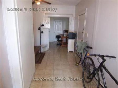
3 Beds, 1.5 Baths, 1,170 sq ft
1645 Commonwealth Ave Unit 18
Brighton, MA 02135
Check Back Soon for Upcoming Availability
| Beds | Baths | Average SF |
|---|---|---|
| 3 Bedrooms 3 Bedrooms 3 Br | 1 Bath 1 Bath 1 Ba | — |
Saint Elizabeth’s is a Brighton neighborhood situated about 10 miles away from Boston. Thanks to Saint Elizabeth’s top border sitting on Highway 20, commuting in and out of Brighton is easy. Some residents travel by car, but buses and railways make commuting via public transportation a breeze.
The neighborhood’s best amenities are two world-renowned hospitals, Saint Elizabeth’s Medical Center and Franciscan Children’s, that sit on the edge of town. Other great amenities of Saint Elizabeth’s include many local parks like Ringer Playground and Chestnut Hill Reservoir, which has great trails and greenspace. This neighborhood is also equipped with cozy coffee shops, restaurants serving international and American classics, and shopping plazas with grocers and convenience stores.
Saint Elizabeth’s has several rental options ranging from apartments to single-family homes.
Learn more about living in St Elizabeth'sBelow are rent ranges for similar nearby apartments
| Beds | Average Size | Lowest | Typical | Premium |
|---|---|---|---|---|
| Studio Studio Studio | 4570-4571 Sq Ft | $1,400 | $2,267 | $5,650 |
| 1 Bed 1 Bed 1 Bed | 3653-3654 Sq Ft | $900 | $2,568 | $10,000 |
| 2 Beds 2 Beds 2 Beds | 3250-3251 Sq Ft | $1,660 | $3,210 | $7,000 |
| 3 Beds 3 Beds 3 Beds | 3759-3760 Sq Ft | $1,210 | $3,888 | $6,682 |
| 4 Beds 4 Beds 4 Beds | 3190 Sq Ft | $900 | $5,409 | $14,200 |
| Colleges & Universities | Distance | ||
|---|---|---|---|
| Colleges & Universities | Distance | ||
| Drive: | 4 min | 1.5 mi | |
| Drive: | 4 min | 1.6 mi | |
| Drive: | 5 min | 2.4 mi | |
| Drive: | 7 min | 3.0 mi |
The GreatSchools Rating helps parents compare schools within a state based on a variety of school quality indicators and provides a helpful picture of how effectively each school serves all of its students. Ratings are on a scale of 1 (below average) to 10 (above average) and can include test scores, college readiness, academic progress, advanced courses, equity, discipline and attendance data. We also advise parents to visit schools, consider other information on school performance and programs, and consider family needs as part of the school selection process.
View GreatSchools Rating Methodology
Data provided by GreatSchools.org © 2025. All rights reserved.
Transportation options available in Brighton include Sutherland Street Station, located 0.2 mile from 1645 Commonwealth Ave Unit 18. 1645 Commonwealth Ave Unit 18 is near General Edward Lawrence Logan International, located 9.6 miles or 18 minutes away.
| Transit / Subway | Distance | ||
|---|---|---|---|
| Transit / Subway | Distance | ||
|
|
Walk: | 3 min | 0.2 mi |
|
|
Walk: | 4 min | 0.2 mi |
|
|
Walk: | 7 min | 0.4 mi |
|
|
Walk: | 10 min | 0.6 mi |
|
|
Drive: | 3 min | 1.2 mi |
| Commuter Rail | Distance | ||
|---|---|---|---|
| Commuter Rail | Distance | ||
|
|
Drive: | 7 min | 3.7 mi |
|
|
Drive: | 9 min | 3.7 mi |
|
|
Drive: | 8 min | 3.8 mi |
| Drive: | 10 min | 4.6 mi | |
|
|
Drive: | 11 min | 5.3 mi |
| Airports | Distance | ||
|---|---|---|---|
| Airports | Distance | ||
|
General Edward Lawrence Logan International
|
Drive: | 18 min | 9.6 mi |
Time and distance from 1645 Commonwealth Ave Unit 18.
| Shopping Centers | Distance | ||
|---|---|---|---|
| Shopping Centers | Distance | ||
| Walk: | 6 min | 0.3 mi | |
| Walk: | 13 min | 0.7 mi | |
| Drive: | 5 min | 1.6 mi |
| Parks and Recreation | Distance | ||
|---|---|---|---|
| Parks and Recreation | Distance | ||
|
Chestnut Hill Reservation
|
Walk: | 12 min | 0.7 mi |
|
John Fitzgerald Kennedy National Historic Site
|
Drive: | 4 min | 1.8 mi |
|
Frederick Law Olmsted National Historic Site
|
Drive: | 6 min | 2.5 mi |
|
Hammond Pond Reservation
|
Drive: | 6 min | 2.7 mi |
|
Coit Observatory
|
Drive: | 6 min | 2.9 mi |
| Hospitals | Distance | ||
|---|---|---|---|
| Hospitals | Distance | ||
| Walk: | 12 min | 0.7 mi | |
| Walk: | 14 min | 0.8 mi | |
| Drive: | 4 min | 1.9 mi |
| Military Bases | Distance | ||
|---|---|---|---|
| Military Bases | Distance | ||
| Drive: | 28 min | 12.9 mi | |
| Drive: | 23 min | 13.4 mi |
You May Also Like
Similar Rentals Nearby
-
Total Monthly Price New$3,450Total Monthly PricePrices include all required monthly fees.12 Month LeaseCondo for Rent
-
-
-
-
-
-
-
-
-
What Are Walk Score®, Transit Score®, and Bike Score® Ratings?
Walk Score® measures the walkability of any address. Transit Score® measures access to public transit. Bike Score® measures the bikeability of any address.
What is a Sound Score Rating?
A Sound Score Rating aggregates noise caused by vehicle traffic, airplane traffic and local sources