164 Hoyt St
164 Hoyt St,
Brooklyn,
NY
11217
2 Weeks Ago
Favorites
164 Hoyt St

Favorites
Check Back Soon for Upcoming Availability
About 164 Hoyt St Brooklyn, NY 11217
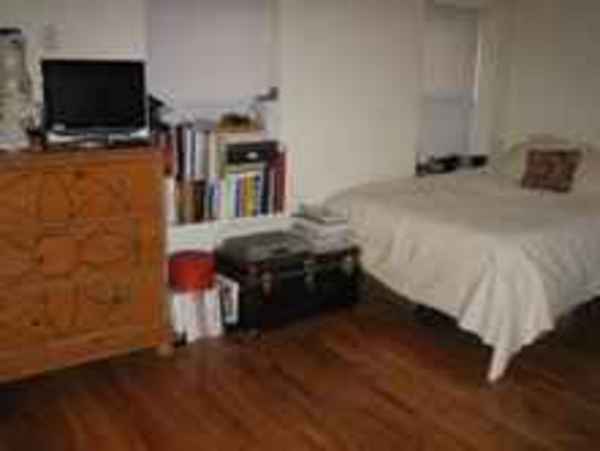
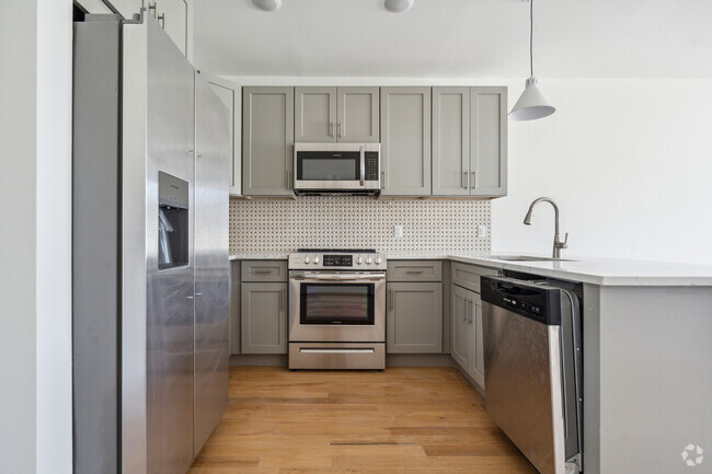
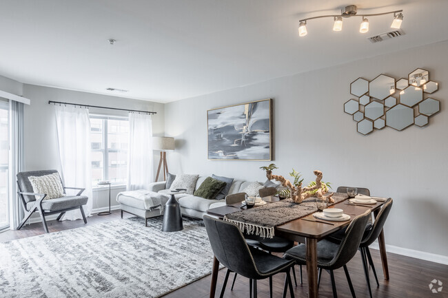
BEAUTIFUL HARDWOOD FLOORS AMAZING OVER SIZED WINDOWS WITH LOTS OF SUNLIGHT, HIGH CEILINGS, LOTS OF CABINET SPACE, AMAZING KITCHEN SPACE.. PERFECT FOR CHEFS HEAT AND HOT WATER INCLUDED INCLUDED ARE PHOTOS OF WHAT IT LOOK LIKE NOW - STAY POSTED FOR UPCOMING PHOTOS OF COMPLETE RENOVATIONS, INCLUDING SHAKER & STAINLESS STEEL KITCHEN.. NO PETS ALLOWED EXTREMELY FRIENDLY NEIGHBORHOOD WELL MANICURED TREE LINED BLOCK 1 BLOCK AWAY FROM F, and G TRAINS, ONLY 8 MINUTES FROM NYC. COMING SOON 15 MINUTES WALK FROM THE BROOKLYN NETS ARENA (BARCLAYS CENTER) JUST A SHORT WALK AWAY FROM ATLANTIC CENTER MALL, and BAM (BROOKLYN ACADEMY OF MUSIC)
164 Hoyt St is an apartment community located in Kings County and the 11217 ZIP Code.
Location
Get Directions
Located in northwestern Brooklyn, just south of downtown, Boerum Hill offers the serenity of a suburb and the excitement of a bustling urban environment. Residents enjoy access to a host of eclectic restaurants and unique shops strewn along the main commercial thoroughfares—Smith Street and Atlantic Avenue.
In more residential parts of the neighborhood, historic brownstones and townhouses nestle up to quiet, tree-lined streets. Boerum Hill has two sister neighborhoods, Cobble Hill and Carol Gardens, which are both situated west of Boerum Hill. The iconic Barclays Center lies just east of Boerum Hill, hosting exciting events like Brooklyn Nets basketball games, boxing matches, and concerts. Convenient subway access makes getting around from Boerum Hill easy.
Learn more about living in Boerum HillBelow are rent ranges for similar nearby apartments
Education
| Colleges & Universities | Distance | ||
|---|---|---|---|
| Colleges & Universities | Distance | ||
| Walk: | 9 min | 0.5 mi | |
| Walk: | 12 min | 0.6 mi | |
| Walk: | 13 min | 0.7 mi | |
| Walk: | 14 min | 0.8 mi |
164 Hoyt St is within 9 minutes or 0.5 mile from ASA College Brooklyn. It is also near Brooklyn Law School and Long Island Univ., Brooklyn.
Transportation options available in Brooklyn include Bergen Street (F,G Line), located 0.2 mile from 164 Hoyt St. 164 Hoyt St is near Laguardia, located 10.5 miles or 20 minutes away, and Newark Liberty International, located 15.1 miles or 27 minutes away.
| Transit / Subway | Distance | ||
|---|---|---|---|
| Transit / Subway | Distance | ||
|
|
Walk: | 3 min | 0.2 mi |
|
|
Walk: | 6 min | 0.3 mi |
|
|
Walk: | 7 min | 0.4 mi |
|
|
Walk: | 12 min | 0.6 mi |
|
|
Walk: | 12 min | 0.6 mi |
| Commuter Rail | Distance | ||
|---|---|---|---|
| Commuter Rail | Distance | ||
|
|
Drive: | 4 min | 1.1 mi |
|
|
Drive: | 8 min | 2.6 mi |
|
|
Drive: | 12 min | 4.1 mi |
|
|
Drive: | 12 min | 4.3 mi |
|
|
Drive: | 18 min | 6.9 mi |
| Airports | Distance | ||
|---|---|---|---|
| Airports | Distance | ||
|
Laguardia
|
Drive: | 20 min | 10.5 mi |
|
Newark Liberty International
|
Drive: | 27 min | 15.1 mi |
Time and distance from 164 Hoyt St.
| Shopping Centers | Distance | ||
|---|---|---|---|
| Shopping Centers | Distance | ||
| Drive: | 4 min | 1.1 mi | |
| Drive: | 4 min | 1.7 mi | |
| Drive: | 8 min | 3.0 mi |
164 Hoyt St has 3 shopping centers within 3.0 miles, which is about a 8-minute drive. The miles and minutes will be for the farthest away property.
| Parks and Recreation | Distance | ||
|---|---|---|---|
| Parks and Recreation | Distance | ||
|
Cobble Hill Park
|
Walk: | 9 min | 0.5 mi |
|
Gowanus Canal
|
Walk: | 13 min | 0.7 mi |
|
Fort Greene Park
|
Drive: | 4 min | 1.2 mi |
|
Cadman Plaza Park
|
Drive: | 4 min | 1.2 mi |
|
Commodore Barry Park
|
Drive: | 4 min | 1.5 mi |
164 Hoyt St has 5 parks within 1.5 miles, including Cobble Hill Park, Gowanus Canal, and Fort Greene Park.
| Hospitals | Distance | ||
|---|---|---|---|
| Hospitals | Distance | ||
| Walk: | 15 min | 0.8 mi | |
| Drive: | 7 min | 2.3 mi | |
| Drive: | 10 min | 3.2 mi |
164 Hoyt St has 3 hospitals within 3.2 miles, the nearest is Brooklyn Hospital Center - Downtown Campus which is 0.8 mile away and a 15 minute walk.
| Military Bases | Distance | ||
|---|---|---|---|
| Military Bases | Distance | ||
| Drive: | 12 min | 4.9 mi | |
| Drive: | 25 min | 12.5 mi |
164 Hoyt St is 4.9 miles from Governors Island Support Center, and is convenient to other military bases, including Military Ocean Terminal.
You May Also Like
Similar Rentals Nearby


What Are Walk Score®, Transit Score®, and Bike Score® Ratings?
Walk Score® measures the walkability of any address. Transit Score® measures access to public transit. Bike Score® measures the bikeability of any address.
What is a Sound Score Rating?
A Sound Score Rating aggregates noise caused by vehicle traffic, airplane traffic and local sources