-
LARGE Apartment Home. 3bd/2ba, walk in clo...

-
-
-
$2,995
/ Month
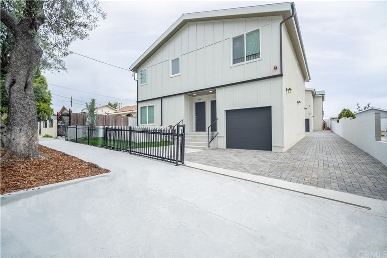
1560 Ricardo St Unit 1560
Los Angeles, CA 90033
Today
|
Edit
Favorites
818-355-2549
-
Bedrooms
3
-
Bathrooms
2
-
Square Feet
1,100 sq ft
-
Available
Available Now
1560 Ricardo St Unit 1560

Favorites
About This Home
$2,995 deposit,
Available Now
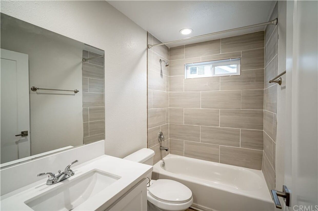
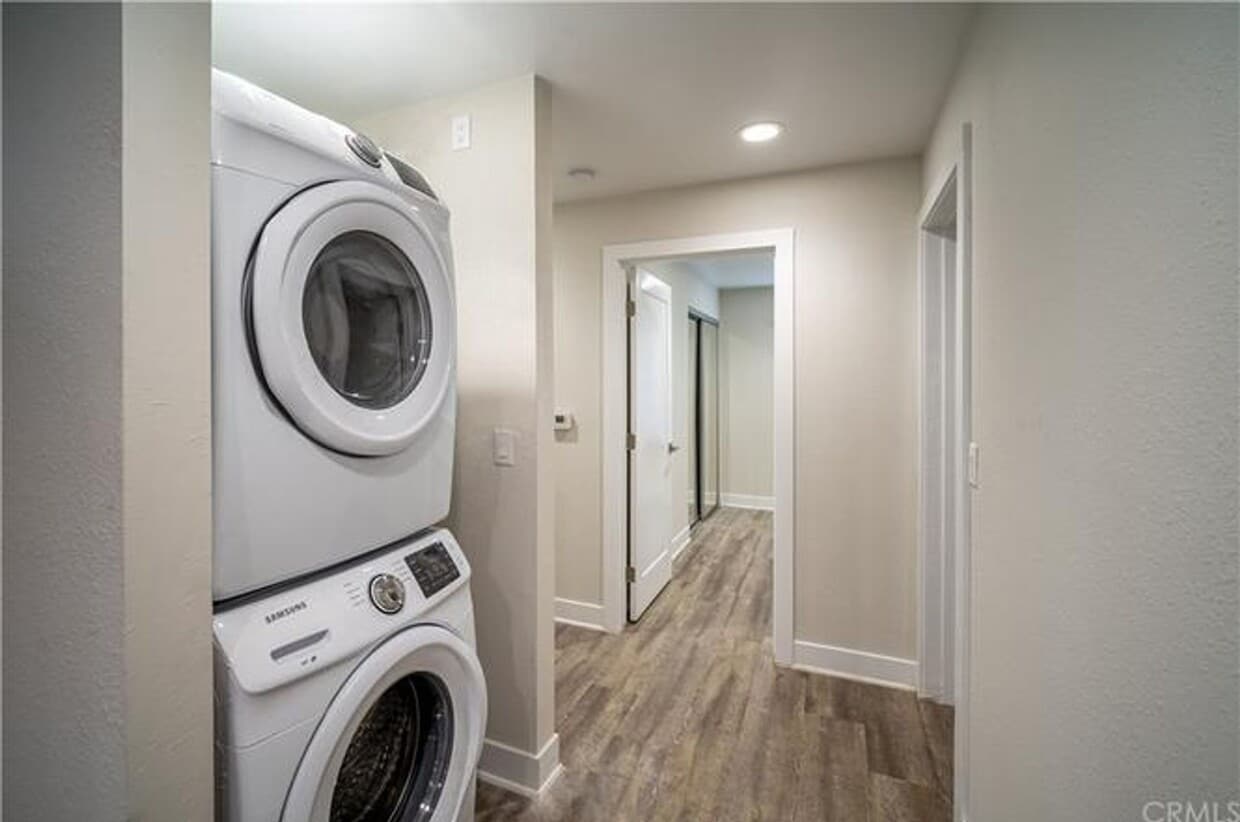
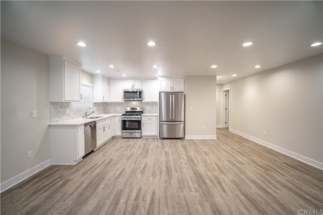
These newly built condo-style units come with new light stained flooring, new paint throughout, recessed lighting, shaker style cabinets, quartz and a backsplash to match. The unit is fully equipped with a dishwasher, stove, refrigerator, and a stackable washer/dryer. Lastly, 2 parking spaces are available. This property is closely located by: -Keck Medicine of USC Medical Center, LAC+USC Medical Center and E.R. -Bravo Medical Magnet School, Murchison Street Elementary, Santa Teresita Elementary, East Los Angeles College (ELAC) -Delicious, local restaurants & eateries -Starbucks -5,10,710,101, & 60 freeways -Public transportation nearby includes: Metro Train (Gold Line Indiana Station) and Bus Stops Utilities: Tenant pays all utilities Please contact Leticia at *We follow all Fair Housing rules and are an Equal Housing provider* This listing provided by: Rick Velasquez, Property Supervisor and Realtor DRE.01783509 LRS Realty & Mgmt Inc.
1560 Ricardo St is an apartment community located in Los Angeles County and the 90033 ZIP Code.
* Price shown is base rent. Excludes user-selected optional fees and variable or usage-based fees and required charges due at or prior to move-in or at move-out. Price, availability, fees, and any applicable rent special are subject to change without notice.
* Square footage definitions vary. Displayed square footage is approximate.
Features
- Dishwasher
Contact
- Listed by LRS Realty & Management, Inc. | LRS Realty & Management, Inc.
- Phone Number
- Contact
Location
Get Directions
Amenities
- Dishwasher
Southeast Los Angeles is directly south of the Fashion District and east of the University of Southern California (USC). This large neighborhood is minutes from downtown Los Angeles, Hollywood, and Beverly Hills, with easy access to the 110 Freeway. This great location places you near sunny beaches, nature trails, and a bevy of leading employers. Students can access both USC and California State University Long Beach from their Southeast LA apartment.
This densely populated, diverse neighborhood features everything from food trucks and corner markets to wide sidewalks and residential areas filled with bungalows, ranch, and Spanish Colonial architecture. Southeast LA features palm trees and mountain views, tampered with gritty undertones to give it a cool, funky vibe.
As for outdoor fun, take your pick between Catalina Island, Venus Beach, or the Santa Monica Pier. Nearby, you’ll find more sunny beaches like White Point, Cabrillo, and Long Beach.
Learn more about living in Southeast Los Angeles
Education
| Colleges & Universities | Distance | ||
|---|---|---|---|
| Colleges & Universities | Distance | ||
| Walk: | 15 min | 0.8 mi | |
| Drive: | 5 min | 2.2 mi | |
| Drive: | 10 min | 4.7 mi | |
| Drive: | 9 min | 5.0 mi |
1560 Ricardo St Unit 1560 is within 15 minutes or 0.8 mile from USC, Health Sciences Campus. It is also near Cal State Los Angeles and East Los Angeles College.
Transportation options available in Los Angeles include Soto, located 1.5 miles from 1560 Ricardo St Unit 1560. 1560 Ricardo St Unit 1560 is near Bob Hope, located 17.4 miles or 24 minutes away, and Los Angeles International, located 19.1 miles or 32 minutes away.
| Transit / Subway | Distance | ||
|---|---|---|---|
| Transit / Subway | Distance | ||
|
|
Drive: | 3 min | 1.5 mi |
|
|
Drive: | 4 min | 2.1 mi |
|
|
Drive: | 5 min | 2.5 mi |
|
|
Drive: | 5 min | 2.8 mi |
|
|
Drive: | 5 min | 2.8 mi |
| Commuter Rail | Distance | ||
|---|---|---|---|
| Commuter Rail | Distance | ||
|
|
Drive: | 8 min | 3.0 mi |
|
|
Drive: | 6 min | 3.0 mi |
|
|
Drive: | 12 min | 6.6 mi |
| Drive: | 10 min | 7.0 mi | |
|
|
Drive: | 16 min | 7.8 mi |
| Airports | Distance | ||
|---|---|---|---|
| Airports | Distance | ||
|
Bob Hope
|
Drive: | 24 min | 17.4 mi |
|
Los Angeles International
|
Drive: | 32 min | 19.1 mi |
Time and distance from 1560 Ricardo St Unit 1560.
| Shopping Centers | Distance | ||
|---|---|---|---|
| Shopping Centers | Distance | ||
| Drive: | 3 min | 1.8 mi | |
| Drive: | 4 min | 1.9 mi | |
| Drive: | 4 min | 2.1 mi |
1560 Ricardo St Unit 1560 has 3 shopping centers within 2.1 miles, which is about a 4-minute drive. The miles and minutes will be for the farthest away property.
| Parks and Recreation | Distance | ||
|---|---|---|---|
| Parks and Recreation | Distance | ||
|
Hollenbeck Lake
|
Drive: | 4 min | 2.1 mi |
|
Audubon Center at Debs Park
|
Drive: | 8 min | 3.8 mi |
|
Elysian Park
|
Drive: | 12 min | 4.8 mi |
|
Elyria Canyon Park
|
Drive: | 11 min | 5.3 mi |
|
Chavez Ravine Arboretum
|
Drive: | 9 min | 5.7 mi |
1560 Ricardo St Unit 1560 has 5 parks within 5.7 miles, including Hollenbeck Lake, Audubon Center at Debs Park, and Elysian Park.
| Hospitals | Distance | ||
|---|---|---|---|
| Hospitals | Distance | ||
| Walk: | 9 min | 0.5 mi | |
| Drive: | 3 min | 1.2 mi | |
| Drive: | 8 min | 3.9 mi |
1560 Ricardo St Unit 1560 has 3 hospitals within 3.9 miles, the nearest is Keck Hospital of USC which is 0.5 mile away and a 9 minute walk.
| Military Bases | Distance | ||
|---|---|---|---|
| Military Bases | Distance | ||
| Drive: | 29 min | 20.7 mi | |
| Drive: | 37 min | 25.4 mi |
1560 Ricardo St Unit 1560 is 20.7 miles from Los Angeles Air Force Base, and is convenient to other military bases, including Los Alamitos Army Airfield.
You May Also Like
Similar Rentals Nearby


What Are Walk Score®, Transit Score®, and Bike Score® Ratings?
Walk Score® measures the walkability of any address. Transit Score® measures access to public transit. Bike Score® measures the bikeability of any address.
What is a Sound Score Rating?
A Sound Score Rating aggregates noise caused by vehicle traffic, airplane traffic and local sources
1560 Ricardo St
Los Angeles, CA 90033