$1,995 / Month
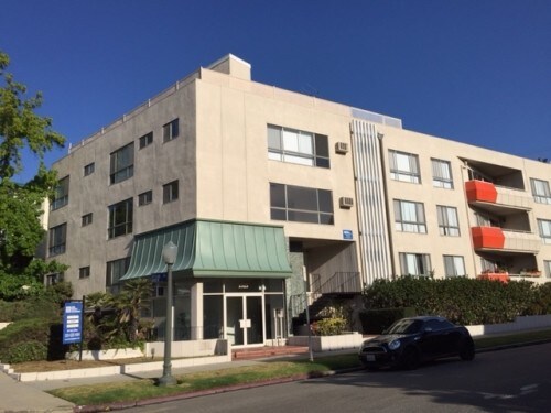
1515 Manning Ave Unit 9
Los Angeles, CA 90024
2 Weeks Ago
Favorites
1515 Manning Ave Unit 9

Favorites
Check Back Soon for Upcoming Availability
| Beds | Baths | Average SF |
|---|---|---|
| 1 Bedroom 1 Bedroom 1 Br | 1 Bath 1 Bath 1 Ba | — |
About This Property
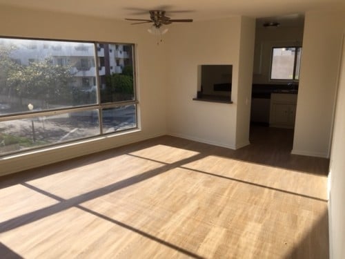
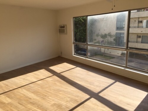
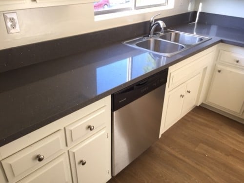
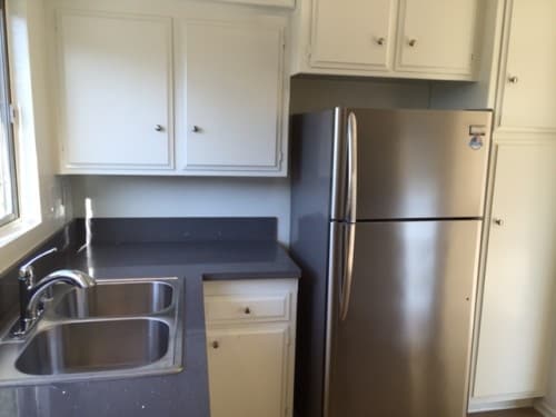
Close proximity to Westwood Village, Century City, Beverly Hills, West Hollywood, 10 and 405 freeways, Santa Monica and Brentwood. Completely remodeled corner 1 Bed and 1 Bath Unit lots of natural light. Beautiful hardwood laminate floors throughout, Recessed Lighting, Gray Quartz Counter Tops in the Kitchen and on top of the Bathroom Vanity. Stainless Steel Appliances: Refrigerator, Gas Stove and Dishwasher. Vertical Blinds through out the unit. Tenant Pays All Utilities - Including Water and Trash (Rubs). 1 Gated and Secured Parking Spot. Building has Elevator and Secured Lobby with Intercom. . Amenities: Elevator, Secured Lobby with Intercom, Gated and Secure Parking. Appliances: Gas stove, Dishwasher, Refrigerator.. Parking: 1 Spot Gated and Covered. https://sternmanagement.com/apartment-for-rent/los-angeles-1-bed-1-bath/1202/ IT490508 - IT49SM1202
1515 Manning Ave is an apartment community located in Los Angeles County and the 90024 ZIP Code.
Features
- Dishwasher
- Refrigerator
Location
Get Directions
Home to UCLA, Westwood lies on the west side of the city and is considered to be one of Los Angeles’ premier neighborhoods. Bordered by Beverly Hills, Bel Air, Brentwood, and Century City, multimillion dollar homes populate the landscape and students pay a premium to rent near campus.
The university itself serves as a major cultural center for the community, including on-campus attractions (such as the Fowler Museum and the Franklin D. Murphy Sculpture Garden) and university-affiliated venues off-campus (The Hammer Museum, the Geffen Playhouse), as well as the presence of thousands of students and faculty members throughout the neighborhood.
Directly south of campus, Westwood Village is a historic shopping district that features blocks of restaurants and businesses catering to both students and the neighborhood’s larger workforce. Many prominent corporations and law offices are found along Wilshire Boulevard, one of the busiest east-west transit corridors across the city.
Learn more about living in WestwoodBelow are rent ranges for similar nearby apartments
| Beds | Average Size | Lowest | Typical | Premium |
|---|---|---|---|---|
| Studio Studio Studio | 360-366 Sq Ft | $1,295 | $2,214 | $3,789 |
| 1 Bed 1 Bed 1 Bed | 690-692 Sq Ft | $955 | $3,234 | $8,750 |
| 2 Beds 2 Beds 2 Beds | 1113-1119 Sq Ft | $995 | $4,581 | $12,900 |
| 3 Beds 3 Beds 3 Beds | 1787-1801 Sq Ft | $1,280 | $7,718 | $27,000 |
| 4 Beds 4 Beds 4 Beds | 1461-1557 Sq Ft | $1,000 | $5,064 | $67,000 |
Amenities
- Dishwasher
- Refrigerator
Education
| Colleges & Universities | Distance | ||
|---|---|---|---|
| Colleges & Universities | Distance | ||
| Drive: | 4 min | 1.4 mi | |
| Drive: | 8 min | 3.0 mi | |
| Drive: | 10 min | 4.0 mi | |
| Drive: | 10 min | 4.0 mi |
1515 Manning Ave Unit 9 is within 4 minutes or 1.4 miles from UCLA. It is also near Santa Monica Coll., Academy and The Art Inst., Los Angeles.
Transportation options available in Los Angeles include Westwood/Rancho Park, located 1.9 miles from 1515 Manning Ave Unit 9. 1515 Manning Ave Unit 9 is near Los Angeles International, located 10.4 miles or 18 minutes away, and Bob Hope, located 18.1 miles or 28 minutes away.
| Transit / Subway | Distance | ||
|---|---|---|---|
| Transit / Subway | Distance | ||
|
|
Drive: | 5 min | 1.9 mi |
| Drive: | 5 min | 2.0 mi | |
|
|
Drive: | 8 min | 2.9 mi |
|
|
Drive: | 7 min | 3.7 mi |
|
|
Drive: | 9 min | 4.9 mi |
| Commuter Rail | Distance | ||
|---|---|---|---|
| Commuter Rail | Distance | ||
|
|
Drive: | 25 min | 13.4 mi |
|
|
Drive: | 27 min | 13.8 mi |
|
|
Drive: | 22 min | 13.8 mi |
|
|
Drive: | 22 min | 14.5 mi |
|
|
Drive: | 28 min | 18.1 mi |
| Airports | Distance | ||
|---|---|---|---|
| Airports | Distance | ||
|
Los Angeles International
|
Drive: | 18 min | 10.4 mi |
|
Bob Hope
|
Drive: | 28 min | 18.1 mi |
Time and distance from 1515 Manning Ave Unit 9.
| Shopping Centers | Distance | ||
|---|---|---|---|
| Shopping Centers | Distance | ||
| Walk: | 10 min | 0.5 mi | |
| Walk: | 15 min | 0.8 mi | |
| Walk: | 15 min | 0.8 mi |
1515 Manning Ave Unit 9 has 3 shopping centers within 0.8 mile, which is about a 15-minute walk. The miles and minutes will be for the farthest away property.
| Parks and Recreation | Distance | ||
|---|---|---|---|
| Parks and Recreation | Distance | ||
|
Mathias Botanical Garden
|
Walk: | 17 min | 0.9 mi |
|
Hannah Carter Japanese Garden
|
Drive: | 7 min | 2.3 mi |
|
Virginia Robinson Gardens
|
Drive: | 9 min | 3.3 mi |
|
Zimmer Children's Museum
|
Drive: | 9 min | 4.6 mi |
|
Franklin Canyon Park
|
Drive: | 17 min | 5.7 mi |
1515 Manning Ave Unit 9 has 5 parks within 5.7 miles, including Mathias Botanical Garden, Hannah Carter Japanese Garden, and Virginia Robinson Gardens.
| Hospitals | Distance | ||
|---|---|---|---|
| Hospitals | Distance | ||
| Drive: | 4 min | 1.3 mi | |
| Drive: | 4 min | 1.4 mi | |
| Drive: | 8 min | 3.2 mi |
1515 Manning Ave Unit 9 has 3 hospitals within 3.2 miles, the nearest is Ronald Reagan UCLA Medical Center which is 1.3 miles away and a 4 minute drive.
| Military Bases | Distance | ||
|---|---|---|---|
| Military Bases | Distance | ||
| Drive: | 18 min | 13.0 mi |
1515 Manning Ave Unit 9 is 13.0 miles and a 18 minute drive from Los Angeles Air Force Base.
You May Also Like
Similar Rentals Nearby


 - AVA Burbank")
 - Violet on Virgil")

What Are Walk Score®, Transit Score®, and Bike Score® Ratings?
Walk Score® measures the walkability of any address. Transit Score® measures access to public transit. Bike Score® measures the bikeability of any address.
What is a Sound Score Rating?
A Sound Score Rating aggregates noise caused by vehicle traffic, airplane traffic and local sources
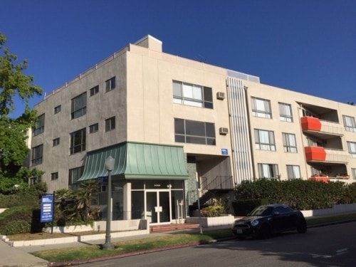
1515 Manning Ave
Los Angeles, CA 90024