
Eighty Nine Dekalb
89 Dekalb Ave,
Brooklyn, NY 11201
$3,740 - $7,845
Studio - 2 Beds


www.brooklyngroup.com Our team of dedicated, innovative real estate agents knows Brooklyn better than just about anyone. We’ll make the process of finding your next NYC home a snap. Finding your place in Brooklyn shouldn’t be a challenge, it should be your next best adventure. Just like living in one of Brooklyn’s vibrant neighborhoods can be. Between our insider knowledge of Brooklyn, exclusive listings and innovative website, you’ll be amazed at how quickly we’ll help you start living in your dream apartment.
15 Cedar St is an apartment community located in Kings County and the 11221 ZIP Code. This area is served by the New York City Geographic District #32 attendance zone.
Fitness Center
Laundry Facilities
Elevator
Roof Terrace
Air Conditioning
Dishwasher
Hardwood Floors
Island Kitchen
Neighboring Williamsburg to the east, Bushwick is a vibrant Brooklyn neighborhood known for its incredible street art, local shops, and diverse cuisine. Bushwick has historically served as a haven for immigrants, and now attracts scores of creative types to its many galleries and converted loft spaces.
In addition to a host of new local businesses, Bushwick offers residents exciting nightlife options and easy subway access. Colorful apartment buildings line quiet residential streets in Bushwick as well, providing plenty of rental opportunities to the community. Numerous neighborhood parks offer a tranquil reprieve from the big-city bustle.
Learn more about living in Bushwick| Colleges & Universities | Distance | ||
|---|---|---|---|
| Colleges & Universities | Distance | ||
| Drive: | 7 min | 2.3 mi | |
| Drive: | 8 min | 2.4 mi | |
| Drive: | 9 min | 3.1 mi | |
| Drive: | 12 min | 3.7 mi |


Transportation options available in Brooklyn include Central Avenue, located 0.2 mile from 15 Cedar St. 15 Cedar St is near LaGuardia, located 8.4 miles or 17 minutes away, and John F Kennedy International, located 11.6 miles or 20 minutes away.
| Transit / Subway | Distance | ||
|---|---|---|---|
| Transit / Subway | Distance | ||
|
|
Walk: | 3 min | 0.2 mi |
|
|
Walk: | 5 min | 0.3 mi |
|
|
Walk: | 7 min | 0.4 mi |
|
|
Walk: | 10 min | 0.5 mi |
|
|
Walk: | 14 min | 0.7 mi |
| Commuter Rail | Distance | ||
|---|---|---|---|
| Commuter Rail | Distance | ||
|
|
Drive: | 6 min | 2.6 mi |
|
|
Drive: | 8 min | 2.6 mi |
|
|
Drive: | 11 min | 3.6 mi |
|
|
Drive: | 12 min | 4.1 mi |
|
|
Drive: | 13 min | 4.4 mi |
| Airports | Distance | ||
|---|---|---|---|
| Airports | Distance | ||
|
LaGuardia
|
Drive: | 17 min | 8.4 mi |
|
John F Kennedy International
|
Drive: | 20 min | 11.6 mi |
Time and distance from 15 Cedar St.
| Shopping Centers | Distance | ||
|---|---|---|---|
| Shopping Centers | Distance | ||
| Drive: | 3 min | 1.3 mi | |
| Drive: | 7 min | 2.0 mi | |
| Drive: | 7 min | 2.7 mi |
| Parks and Recreation | Distance | ||
|---|---|---|---|
| Parks and Recreation | Distance | ||
|
Maria Hernandez Park
|
Walk: | 12 min | 0.6 mi |
|
Martinez Playground
|
Drive: | 4 min | 1.6 mi |
|
Sternberg Park
|
Drive: | 4 min | 1.7 mi |
|
Hattie Carthan Garden
|
Drive: | 6 min | 1.9 mi |
|
St. John's Park
|
Drive: | 7 min | 2.0 mi |
| Hospitals | Distance | ||
|---|---|---|---|
| Hospitals | Distance | ||
| Walk: | 15 min | 0.8 mi | |
| Walk: | 16 min | 0.9 mi | |
| Drive: | 7 min | 2.1 mi |
| Military Bases | Distance | ||
|---|---|---|---|
| Military Bases | Distance | ||
| Drive: | 19 min | 7.2 mi | |
| Drive: | 30 min | 11.5 mi |
What Are Walk Score®, Transit Score®, and Bike Score® Ratings?
Walk Score® measures the walkability of any address. Transit Score® measures access to public transit. Bike Score® measures the bikeability of any address.
What is a Sound Score Rating?
A Sound Score Rating aggregates noise caused by vehicle traffic, airplane traffic and local sources
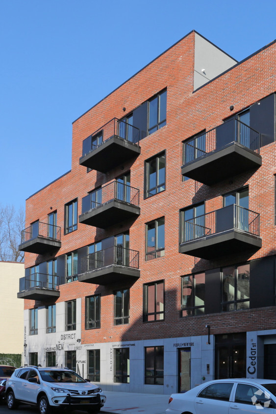
15 Cedar St
Brooklyn, NY 11221


