
Citrus Commons
14150 Riverside Dr,
Sherman Oaks, CA 91423
Studio - 2 Beds $2,995 - $6,995
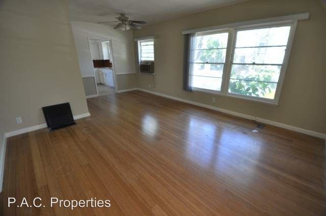
Vintage Style Apartment Just South of Ventura Blvd! Walk to Great Dining! Original Wood Floors! - This Charming Apartment is Located South Of Ventura Boulevard in the Hills of Sherman Oaks! Whether You Desire A Gorgeous View Of A Tree Lined Street Or A Five Minute Walk To Some Of Sherman Oaks Finest Restaurants And Shopping, your new home will not disappoint!
14418 Dickens St is an apartment community located in Los Angeles County and the 91423 ZIP Code. This area is served by the Los Angeles Unified attendance zone.
Air Conditioning
Dishwasher
Hardwood Floors
Tile Floors
A thriving neighborhood in the San Fernando Valley region of Los Angeles, Sherman Oaks is located 16 miles northwest of downtown Los Angeles and just 12 miles northeast of Santa Monica, housing the famous Santa Monica Pier. With other popular cities like Beverly Hills and Hollywood nearby, residents have convenient access to everything wonderful and exciting about living in Los Angeles, California.
With a portion of the Santa Monica Mountains within its boundaries, Sherman Oaks offers beautiful natural landscapes paired with modern amenities and a lively community. Sherman Oaks provides an incredible selection of restaurants, shopping, entertainment, community parks, and more.
With access to LAX, the Los Angeles International Airport, and several interstate highways, residents have convenient and easy travel options. Sherman Oaks is within a short drive of the Los Angeles Zoo, Universal Studios Hollywood, and the famous Hollywood sign.
Learn more about living in Sherman Oaks| Colleges & Universities | Distance | ||
|---|---|---|---|
| Colleges & Universities | Distance | ||
| Drive: | 8 min | 4.2 mi | |
| Drive: | 10 min | 7.4 mi | |
| Drive: | 15 min | 9.4 mi | |
| Drive: | 21 min | 10.5 mi |


Transportation options available in Sherman Oaks include Universal City/Studio City, located 5.3 miles from 14418 Dickens St. 14418 Dickens St is near Bob Hope, located 8.7 miles or 15 minutes away, and Los Angeles International, located 18.8 miles or 27 minutes away.
| Transit / Subway | Distance | ||
|---|---|---|---|
| Transit / Subway | Distance | ||
|
|
Drive: | 9 min | 5.3 mi |
|
|
Drive: | 9 min | 6.5 mi |
|
|
Drive: | 14 min | 9.4 mi |
|
|
Drive: | 13 min | 9.7 mi |
|
|
Drive: | 17 min | 11.8 mi |
| Commuter Rail | Distance | ||
|---|---|---|---|
| Commuter Rail | Distance | ||
|
|
Drive: | 9 min | 4.8 mi |
|
|
Drive: | 15 min | 9.2 mi |
|
|
Drive: | 15 min | 9.4 mi |
|
|
Drive: | 16 min | 9.7 mi |
| Drive: | 16 min | 10.1 mi |
| Airports | Distance | ||
|---|---|---|---|
| Airports | Distance | ||
|
Bob Hope
|
Drive: | 15 min | 8.7 mi |
|
Los Angeles International
|
Drive: | 27 min | 18.8 mi |
Time and distance from 14418 Dickens St.
| Shopping Centers | Distance | ||
|---|---|---|---|
| Shopping Centers | Distance | ||
| Walk: | 3 min | 0.2 mi | |
| Walk: | 5 min | 0.3 mi | |
| Walk: | 5 min | 0.3 mi |
| Parks and Recreation | Distance | ||
|---|---|---|---|
| Parks and Recreation | Distance | ||
|
The Japanese Garden
|
Drive: | 6 min | 3.8 mi |
|
Sepulveda Basin Wildlife Reserve
|
Drive: | 10 min | 4.2 mi |
|
Skirball Cultural Center
|
Drive: | 8 min | 4.9 mi |
|
Franklin Canyon Park
|
Drive: | 13 min | 4.9 mi |
|
Sooky Goldman Nature Center
|
Drive: | 14 min | 5.0 mi |
| Hospitals | Distance | ||
|---|---|---|---|
| Hospitals | Distance | ||
| Walk: | 15 min | 0.8 mi | |
| Drive: | 4 min | 2.5 mi | |
| Drive: | 7 min | 4.2 mi |
| Military Bases | Distance | ||
|---|---|---|---|
| Military Bases | Distance | ||
| Drive: | 27 min | 21.4 mi |
What Are Walk Score®, Transit Score®, and Bike Score® Ratings?
Walk Score® measures the walkability of any address. Transit Score® measures access to public transit. Bike Score® measures the bikeability of any address.
What is a Sound Score Rating?
A Sound Score Rating aggregates noise caused by vehicle traffic, airplane traffic and local sources


 - AVA Burbank")


 - Violet on Virgil")