$2,499
Total Monthly Price3 Beds, 2 Baths, 1,386 sq ft


Bedrooms
3
Bathrooms
2
Square Feet
1,400 sq ft
Available
Available Oct 25

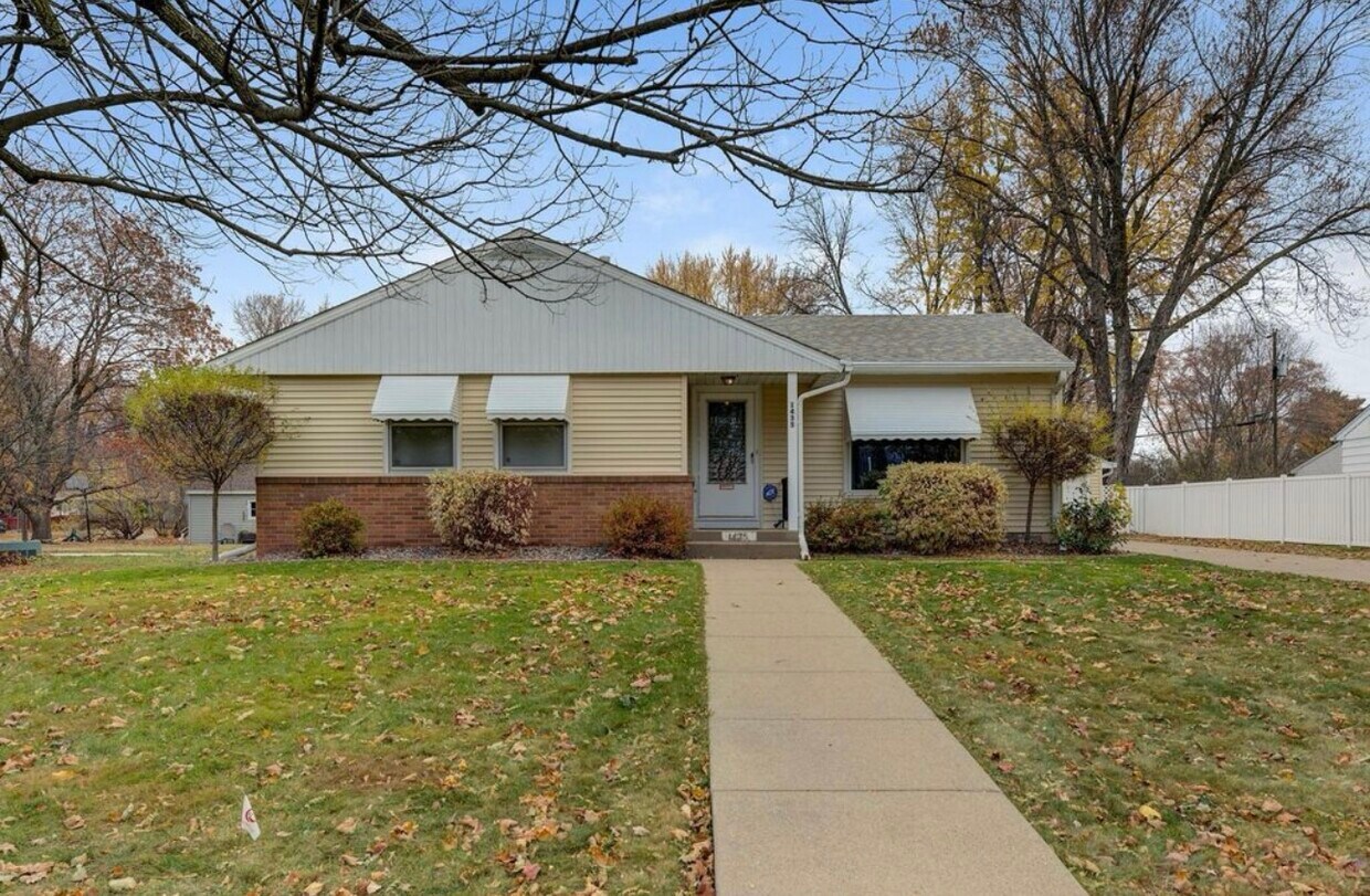
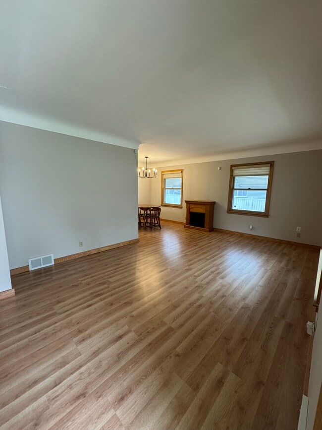
3 bedroom, 2 bathroom house in Saint Paul. Amenities included: central air, central heat, dishwasher, hardwood floors, storage, washer dryer, laundry in building, large fully fenced backyard, 4 car garage, gazebo, irrigation system, and security system. Utilities included: water and garbage/recycling. Tenants responsible for lawn care and snow removal. Pet friendly. Date Available: Oct 25th 2025. $2,500/month rent. $2,500 security deposit required. Please submit the form on this page or contact Logan Strang at to learn more. This property is managed by a responsible landlord using Avail landlord software.
1435 Price Ave is a house located in Ramsey County and the 55109 ZIP Code. This area is served by the North St Paul-Maplewood School Dist attendance zone.
The fees below are based on community-supplied data and may exclude additional fees and utilities.
Thanks to some odd geography, Maplewood has something of a split personality. This first-ring St. Paul suburb can be described as being shaped like a frying pan. The main business and residential area lies primarily to the north and east of St. Paul, while the chief amenities, such as the community center and an indoor mall, lie in the "pan." South Maplewood, or the "pan handle," runs south along Interstate 494 and has fewer business amenities. Residents of this area tend to shop in bordering Woodbury, since it takes a good half hour to get from the southern tip of Maplewood to the main northern business district.
Meanwhile, Oakdale lies between the two sections, just east of Maplewood's pan handle and north of Woodbury. This young suburb is a quiet bedroom community with a scattering of business districts. Cornfields make up its eastern portion, giving the area a distinctly rural vibe, even though it's just 10 minutes outside of downtown St. Paul.
Learn more about living in Maplewood-Oakdale| Colleges & Universities | Distance | ||
|---|---|---|---|
| Colleges & Universities | Distance | ||
| Drive: | 9 min | 3.9 mi | |
| Drive: | 10 min | 5.9 mi | |
| Drive: | 13 min | 6.6 mi | |
| Drive: | 18 min | 9.6 mi |
 The GreatSchools Rating helps parents compare schools within a state based on a variety of school quality indicators and provides a helpful picture of how effectively each school serves all of its students. Ratings are on a scale of 1 (below average) to 10 (above average) and can include test scores, college readiness, academic progress, advanced courses, equity, discipline and attendance data. We also advise parents to visit schools, consider other information on school performance and programs, and consider family needs as part of the school selection process.
Transportation options available in Saint Paul include Union Depot Station, located 4.9 miles from 1435 Price Ave. 1435 Price Ave is near Minneapolis-St Paul International/Wold-Chamberlain, located 14.4 miles or 26 minutes away.
| Transit / Subway | Distance | ||
|---|---|---|---|
| Transit / Subway | Distance | ||
| Drive: | 11 min | 4.9 mi | |
| Drive: | 11 min | 5.0 mi | |
| Drive: | 11 min | 5.4 mi | |
| Drive: | 11 min | 5.6 mi | |
| Drive: | 11 min | 5.6 mi |
| Commuter Rail | Distance | ||
|---|---|---|---|
| Commuter Rail | Distance | ||
|
|
Drive: | 11 min | 4.9 mi |
|
|
Drive: | 26 min | 15.3 mi |
|
|
Drive: | 24 min | 16.2 mi |
|
|
Drive: | 34 min | 24.3 mi |
|
|
Drive: | 35 min | 25.9 mi |
| Airports | Distance | ||
|---|---|---|---|
| Airports | Distance | ||
|
Minneapolis-St Paul International/Wold-Chamberlain
|
Drive: | 26 min | 14.4 mi |
Time and distance from 1435 Price Ave.
| Shopping Centers | Distance | ||
|---|---|---|---|
| Shopping Centers | Distance | ||
| Walk: | 17 min | 0.9 mi | |
| Drive: | 4 min | 1.7 mi | |
| Drive: | 4 min | 1.7 mi |
| Parks and Recreation | Distance | ||
|---|---|---|---|
| Parks and Recreation | Distance | ||
|
Keller Regional Park
|
Drive: | 3 min | 1.2 mi |
|
Phalen Park
|
Drive: | 6 min | 2.1 mi |
|
Phelan Regional Park
|
Drive: | 7 min | 2.3 mi |
|
Arlington/Arkwright Park
|
Drive: | 8 min | 3.4 mi |
|
Maplewood Nature Center
|
Drive: | 10 min | 5.3 mi |
| Hospitals | Distance | ||
|---|---|---|---|
| Hospitals | Distance | ||
| Drive: | 9 min | 4.2 mi | |
| Drive: | 11 min | 5.2 mi | |
| Drive: | 11 min | 5.2 mi |
| Military Bases | Distance | ||
|---|---|---|---|
| Military Bases | Distance | ||
| Drive: | 25 min | 13.2 mi |
$2,499
Total Monthly Price3 Beds, 2 Baths, 1,386 sq ft
$2,200
Total Monthly Price4 Beds, 1 Bath, 1,500 sq ft
$2,295
Total Monthly Price3 Beds, 1.5 Baths, 1,200 sq ft
$2,500
Total Monthly Price3 Beds, 2 Baths, 1,700 sq ft
$3,200
Total Monthly Price4 Beds, 1.5 Baths, 1,868 sq ft
$1,975
Total Monthly Price3 Beds, 1 Bath, 1,536 sq ft
$2,600
Total Monthly Price4 Beds, 2 Baths, 2,400 sq ft
$2,350
Total Monthly Price3 Beds, 1.5 Baths, 1,424 sq ft
$1,950
Total Monthly Price4 Beds, 2 Baths, 1,850 sq ft
What Are Walk Score®, Transit Score®, and Bike Score® Ratings?
Walk Score® measures the walkability of any address. Transit Score® measures access to public transit. Bike Score® measures the bikeability of any address.
What is a Sound Score Rating?
A Sound Score Rating aggregates noise caused by vehicle traffic, airplane traffic and local sources