$2,050 / Month
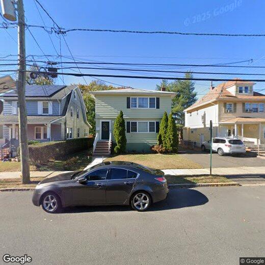
142 Walnut St Unit 2
Bloomfield, NJ 07003
2 Weeks Ago
Favorites
142 Walnut St Unit 2

Favorites
Check Back Soon for Upcoming Availability
| Beds | Baths | Average SF |
|---|---|---|
| 3 Bedrooms 3 Bedrooms 3 Br | 1 Bath 1 Bath 1 Ba | — |
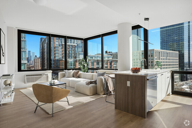
About This Property
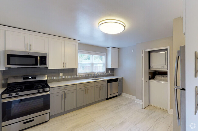
Welcome to 142 Walnut St. This charming and well maintained 3 bedroom,1 full bath apartment on 2nd floor is available and ready to move in! Very spacious 2nd floor offers living room with wood floors. The huge eat-in kitchen has lots of cabinet and counter space. HEAT and HOT WATER are included in rent. Enjoy the conveniences and updates which makes for a comfortable place to live. The proximity to bus lines, light rail and train stations to NYC makes this a commuters dream. Less than 1.3 miles to both train stations to NYC!
142 Walnut St is an apartment community located in Essex County and the 07003 ZIP Code.
Location
Get Directions
Stretched along the Garden State Parkway, the Township of Bloomfield sits in Essex County adjacent to the Township of Montclair. Bloomfield is regarded as an up-and-coming area, boasting convenient access to New York City via major roadways, highways, buses, trains, commuter rail, and light rail. Bloomfield is also close to two major airports, Newark Liberty International and LaGuardia.
In addition to its central locale, Bloomfield offers residents access to a wide range of amenities and services. Quaint shops, cafes, and restaurants line the downtown area on Broad Street in Bloomfield. Large local parks such as Brookdale and Watsessing provide plenty of options for outdoor recreation as well as the behemoth neighbors of South Mountain Reservation and Eagle Rock Reservation. Bloomfield’s appeal is as diverse as its population and offerings, with the township experiencing record growth in residential, retail, and entertainment venues.
Learn more about living in Bloomfield
Education
| Colleges & Universities | Distance | ||
|---|---|---|---|
| Colleges & Universities | Distance | ||
| Walk: | 5 min | 0.3 mi | |
| Drive: | 8 min | 4.2 mi | |
| Drive: | 9 min | 4.4 mi | |
| Drive: | 9 min | 4.7 mi |
142 Walnut St Unit 2 is within 5 minutes or 0.3 mile from Bloomfield College. It is also near Rutgers, Newark Campus and N.J. Inst. of Technology.
Transportation options available in Bloomfield include Grove Street, located 1.5 miles from 142 Walnut St Unit 2. 142 Walnut St Unit 2 is near Newark Liberty International, located 10.0 miles or 17 minutes away, and Laguardia, located 25.3 miles or 44 minutes away.
| Transit / Subway | Distance | ||
|---|---|---|---|
| Transit / Subway | Distance | ||
|
|
Drive: | 3 min | 1.5 mi |
|
|
Drive: | 4 min | 1.8 mi |
|
|
Drive: | 4 min | 1.9 mi |
|
|
Drive: | 5 min | 2.3 mi |
|
|
Drive: | 4 min | 2.4 mi |
| Commuter Rail | Distance | ||
|---|---|---|---|
| Commuter Rail | Distance | ||
|
|
Walk: | 15 min | 0.8 mi |
|
|
Walk: | 18 min | 1.0 mi |
|
|
Drive: | 3 min | 1.4 mi |
|
|
Drive: | 3 min | 1.6 mi |
|
|
Drive: | 5 min | 2.4 mi |
| Airports | Distance | ||
|---|---|---|---|
| Airports | Distance | ||
|
Newark Liberty International
|
Drive: | 17 min | 10.0 mi |
|
Laguardia
|
Drive: | 44 min | 25.3 mi |
Time and distance from 142 Walnut St Unit 2.
| Shopping Centers | Distance | ||
|---|---|---|---|
| Shopping Centers | Distance | ||
| Walk: | 12 min | 0.7 mi | |
| Drive: | 3 min | 1.2 mi | |
| Drive: | 3 min | 1.3 mi |
142 Walnut St Unit 2 has 3 shopping centers within 1.3 miles, which is about a 3-minute walk. The miles and minutes will be for the farthest away property.
| Parks and Recreation | Distance | ||
|---|---|---|---|
| Parks and Recreation | Distance | ||
|
Van Vleck House & Gardens
|
Drive: | 6 min | 3.0 mi |
|
Branch Brook Park
|
Drive: | 7 min | 3.1 mi |
|
Edison National Historic Site
|
Drive: | 9 min | 3.9 mi |
|
Newark Museum and Dreyfuss Planetarium
|
Drive: | 8 min | 4.3 mi |
|
Kearny Marsh
|
Drive: | 11 min | 5.4 mi |
142 Walnut St Unit 2 has 5 parks within 5.4 miles, including Branch Brook Park, Van Vleck House & Gardens, and Edison National Historic Site.
| Hospitals | Distance | ||
|---|---|---|---|
| Hospitals | Distance | ||
| Drive: | 6 min | 3.4 mi | |
| Drive: | 8 min | 4.2 mi | |
| Drive: | 8 min | 4.5 mi |
142 Walnut St Unit 2 has 3 hospitals within 4.5 miles, the nearest is East Orange General Hospital which is 3.4 miles away and a 6 minute drive.
| Military Bases | Distance | ||
|---|---|---|---|
| Military Bases | Distance | ||
| Drive: | 23 min | 13.9 mi | |
| Drive: | 32 min | 14.9 mi | |
| Drive: | 38 min | 22.0 mi |
142 Walnut St Unit 2 has 3 military bases within 22.0 miles, the nearest is Military Ocean Terminal which is 13.9 miles away and a 23 minute drive.
You May Also Like
Similar Rentals Nearby

What Are Walk Score®, Transit Score®, and Bike Score® Ratings?
Walk Score® measures the walkability of any address. Transit Score® measures access to public transit. Bike Score® measures the bikeability of any address.
What is a Sound Score Rating?
A Sound Score Rating aggregates noise caused by vehicle traffic, airplane traffic and local sources

142 Walnut St
Bloomfield, NJ 07003