
$3,350
/ Month
14120 Silver Teal Way
Upper Marlboro, MD 20774
Today
|
Edit
Favorites
301-237-7455
-
Bedrooms
4
-
Bathrooms
3.5
-
Square Feet
2,288 sq ft
-
Available
Available Jan 20
Highlight
- Basement
14120 Silver Teal Way

Favorites
About This Home
Available Jan 20
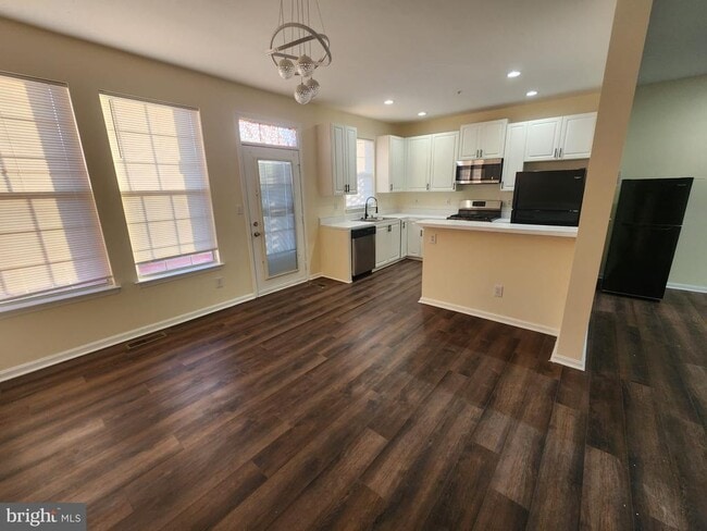
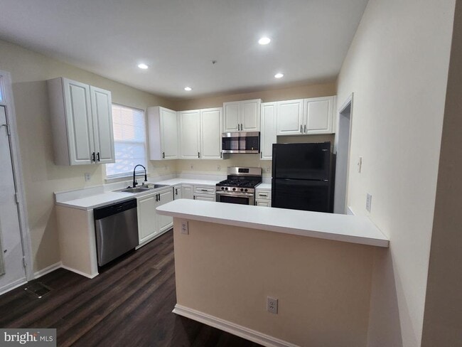
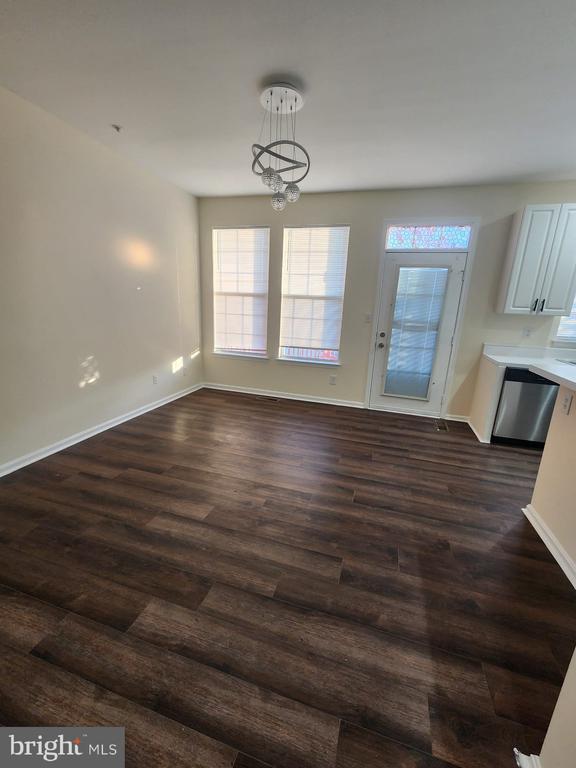
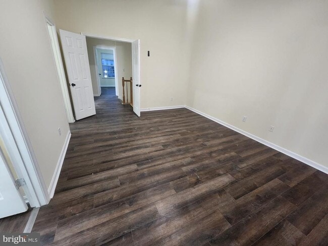
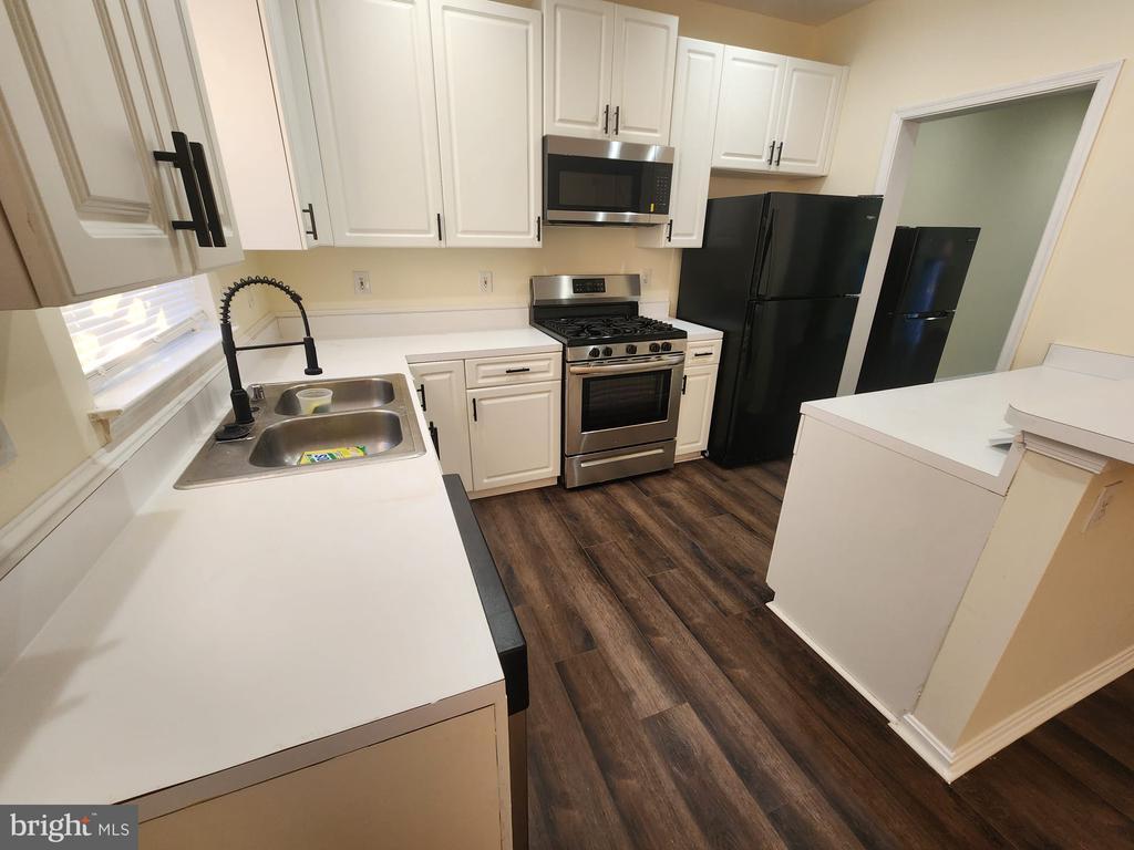
This beautifully renovated townhouse in the sought-after Perrywood subdivision offers 4 bedrooms, 3.5 bathrooms, and a garage, blending modern upgrades with comfortable living. The thoughtful layout features bright, open living and dining spaces ideal for everyday life or entertaining. Stylish updates throughout give the home a fresh, move-in-ready vibe, while spacious bedrooms provide flexibility for family, guests, or a home office. Multiple bathrooms ensure convenience and privacy. Perrywood’s amenities include a pool, tennis and basketball courts, playgrounds, and more, all in a friendly neighborhood with easy access to shopping, dining, and major commuter routes.
14120 Silver Teal Way is a townhome located in Prince George's County and the 20774 ZIP Code. This area is served by the Prince George's County Public Schools attendance zone.
* Price shown is base rent. Excludes user-selected optional fees and variable or usage-based fees and required charges due at or prior to move-in or at move-out. Price, availability, fees, and any applicable rent special are subject to change without notice.
* Square footage definitions vary. Displayed square footage is approximate.
Townhome Features
- Basement
Contact
- Listed by Adeyinka A Ogunsanya | Ultimate Properties, LLC.
- Phone Number
- Contact
-
Source
 Bright MLS, Inc.
Copyright © 2026 Bright MLS, Inc.
Location
Get Directions
Amenities
- Basement
Popularly known as a government district in Prince George’s County in the state of Maryland, Upper Marlboro offers residents a small-town vibe. Lined with an assortment of businesses, Main Street provides immediate access to the courthouse and county administrative building.
You'll find a combination of busy thoroughfares within the city and a quiet atmosphere in the residential suburbs. To the west of downtown are residential homes on quiet streets with mostly single-family homes, parks, and civic centers. Take a short walk from Main Street to access the Prince George’s County Public system. Aside from the few grocery stores and big-box retailers, the rural nature of the area is the biggest draw for residents. But it also means you might have to head to surrounding areas for more shopping and restaurant options.
Learn more about living in Greater Upper Marlboro
Education
| Colleges & Universities | Distance | ||
|---|---|---|---|
| Colleges & Universities | Distance | ||
| Drive: | 7 min | 3.6 mi | |
| Drive: | 11 min | 6.0 mi | |
| Drive: | 25 min | 13.4 mi | |
| Drive: | 24 min | 15.0 mi |
14120 Silver Teal Way is within 7 minutes or 3.6 miles from Prince George's Comm. Coll.. It is also near Univ. of Md. Univ. Coll. and Bowie State University.
Schools


Public Elementary School
Grades K-5
517 Students
Attendance Zone
Public Elementary School
Grades PK-5
746 Students
Nearby
Public Middle School
Grades 6-8
915 Students
Attendance Zone
Public High School
Grades 9-12
939 Students
Attendance Zone
Private Elementary, Middle & High School
Grades PK-12
400 Students
Nearby
Private Middle & High School
Grades 6-12
120 Students
Nearby
School data provided by
 The GreatSchools Rating helps parents compare schools within a state based on a variety of school quality indicators and provides a helpful picture of how effectively each school serves all of its students. Ratings are on a scale of 1 (below average) to 10 (above average) and can include test scores, college readiness, academic progress, advanced courses, equity, discipline and attendance data. We also advise parents to visit schools, consider other information on school performance and programs, and consider family needs as part of the school selection process.
View GreatSchools Rating Methodology
Data provided by GreatSchools.org © 2026. All rights reserved.
View GreatSchools Rating Methodology
Data provided by GreatSchools.org © 2026. All rights reserved.
Transportation options available in Upper Marlboro include Largo Town Center, located 5.3 miles from 14120 Silver Teal Way. 14120 Silver Teal Way is near Ronald Reagan Washington Ntl, located 21.7 miles or 35 minutes away, and Baltimore/Washington International Thurgood Marshall, located 31.4 miles or 47 minutes away.
| Transit / Subway | Distance | ||
|---|---|---|---|
| Transit / Subway | Distance | ||
|
|
Drive: | 11 min | 5.3 mi |
|
|
Drive: | 12 min | 7.1 mi |
|
|
Drive: | 13 min | 8.2 mi |
|
Capitol Heights, Blue/Silver Line Center Platform
|
Drive: | 15 min | 9.0 mi |
|
|
Drive: | 17 min | 10.2 mi |
| Commuter Rail | Distance | ||
|---|---|---|---|
| Commuter Rail | Distance | ||
| Drive: | 17 min | 10.2 mi | |
|
|
Drive: | 17 min | 10.2 mi |
|
|
Drive: | 18 min | 10.5 mi |
|
Bowie State Marc Sb
|
Drive: | 25 min | 13.4 mi |
|
Bowie State Marc Nb
|
Drive: | 25 min | 13.4 mi |
| Airports | Distance | ||
|---|---|---|---|
| Airports | Distance | ||
|
Ronald Reagan Washington Ntl
|
Drive: | 35 min | 21.7 mi |
|
Baltimore/Washington International Thurgood Marshall
|
Drive: | 47 min | 31.4 mi |
Time and distance from 14120 Silver Teal Way.
| Shopping Centers | Distance | ||
|---|---|---|---|
| Shopping Centers | Distance | ||
| Drive: | 6 min | 2.7 mi | |
| Drive: | 7 min | 3.0 mi | |
| Drive: | 6 min | 3.2 mi |
14120 Silver Teal Way has 3 shopping centers within 3.2 miles, which is about a 6-minute drive. The miles and minutes will be for the farthest away property.
| Parks and Recreation | Distance | ||
|---|---|---|---|
| Parks and Recreation | Distance | ||
|
Watkins Nature Center
|
Drive: | 4 min | 1.7 mi |
|
Old Maryland Farm
|
Drive: | 4 min | 1.8 mi |
|
Watkins Regional Park
|
Drive: | 8 min | 2.8 mi |
|
School House Pond
|
Drive: | 8 min | 4.7 mi |
|
Cheltenham Wetlands Park
|
Drive: | 10 min | 5.8 mi |
14120 Silver Teal Way has 5 parks within 5.8 miles, including Watkins Nature Center, Old Maryland Farm, and Watkins Regional Park.
| Hospitals | Distance | ||
|---|---|---|---|
| Hospitals | Distance | ||
| Drive: | 17 min | 10.2 mi | |
| Drive: | 19 min | 11.0 mi | |
| Drive: | 24 min | 14.8 mi |
14120 Silver Teal Way has 3 hospitals within 14.8 miles, the nearest is University of Maryland Prince George's Hospital Center which is 10.2 miles away and a 17 minute drive.
| Military Bases | Distance | ||
|---|---|---|---|
| Military Bases | Distance | ||
| Drive: | 18 min | 9.7 mi |
14120 Silver Teal Way is 9.7 miles and a 18 minute drive from Andrews Airforce Base.
You May Also Like
Similar Rentals Nearby


What Are Walk Score®, Transit Score®, and Bike Score® Ratings?
Walk Score® measures the walkability of any address. Transit Score® measures access to public transit. Bike Score® measures the bikeability of any address.
What is a Sound Score Rating?
A Sound Score Rating aggregates noise caused by vehicle traffic, airplane traffic and local sources
14120 Silver Teal Way
Upper Marlboro, MD 20774