

$3,100 / Month
13259 Maple Ave Unit Maple Ave Flushing Queens
Flushing, NY 11355
2 Weeks Ago
Favorites
917-473-9691
-
Bedrooms
3
-
Bathrooms
2
-
Square Feet
900 sq ft
-
Available
Available Now
Highlight
- Smoke Free
13259 Maple Ave Unit Maple Ave Flushing Queens

Favorites
About This Home
12 Month Lease,
$3,100 deposit,
Available Now
Beautiful & bright apt in the busy Flushing area easily accessible to the 7 train or LIRR or bus Q58. Recently renovated with modern looks. 2-3 mins by feet to the closest Supermarket. Cross streets are Main St and College Point Blvd. 2nd floor Rear apartment building, with minimal traffic noises from the busy streets. No feline pets! Thank you!
13259 Maple Ave is an apartment community located in Queens County and the 11355 ZIP Code. This area is served by the New York City Geographic District #25 attendance zone.
* Price shown is base rent and may not include non-optional fees and utilities.
Price, availability, fees, and any applicable rent special are subject to change without notice.
* Square footage definitions vary. Displayed square footage is approximate.
Apartment Features
- Smoke Free
Fees and Policies
The fees below are based on community-supplied data and may exclude additional fees and utilities.
Details
Utilities Included
-
Water
Property Information
-
3 units
Contact
- Phone Number
Location
Get Directions
Situated in Queens, Flushing is a vibrant community home to diverse attractions, architecture, and cuisine. Flushing residents enjoy access to a spectacular Chinatown that rivals the one in Manhattan in addition to a host of dynamic dining and shopping opportunities.
Flushing contains the expansive Flushing Meadows Corona Park and its numerous museums, athletic fields, lush gardens, performance venues, and notable landmarks. Located just ten miles east of Manhattan, Flushing is easy to commute and travel from with access to the subway’s 7 train, Long Island Rail Road, LaGuardia Airport, and Interstates 678 and 495.
Learn more about living in Flushing
Education
| Colleges & Universities | Distance | ||
|---|---|---|---|
| Colleges & Universities | Distance | ||
| Drive: | 5 min | 1.8 mi | |
| Drive: | 9 min | 4.2 mi | |
| Drive: | 10 min | 5.5 mi | |
| Drive: | 10 min | 5.9 mi |
13259 Maple Ave Unit Maple Ave Flushing Queens is within 5 minutes or 1.8 miles from Queens College. It is also near St. John's University and Queensborough Comm. Coll..
Schools


Public Elementary School
Grades PK-5
699 Students
Attendance Zone
Public Middle School
Grades 6-8
617 Students
Attendance Zone
Public High School
Grades 9-12
3,003 Students
Attendance Zone
Private Elementary & Middle School
Grades PK-8
269 Students
Nearby
Private Middle & High School
Grades 8-12
36 Students
Nearby
School data provided by
 The GreatSchools Rating helps parents compare schools within a state based on a variety of school quality indicators and provides a helpful picture of how effectively each school serves all of its students. Ratings are on a scale of 1 (below average) to 10 (above average) and can include test scores, college readiness, academic progress, advanced courses, equity, discipline and attendance data. We also advise parents to visit schools, consider other information on school performance and programs, and consider family needs as part of the school selection process.
View GreatSchools Rating Methodology
Data provided by GreatSchools.org © 2025. All rights reserved.
View GreatSchools Rating Methodology
Data provided by GreatSchools.org © 2025. All rights reserved.
Transportation options available in Flushing include Flushing-Main Street, located 0.5 mile from 13259 Maple Ave Unit Maple Ave Flushing Queens. 13259 Maple Ave Unit Maple Ave Flushing Queens is near LaGuardia, located 3.8 miles or 10 minutes away, and John F Kennedy International, located 9.7 miles or 14 minutes away.
| Transit / Subway | Distance | ||
|---|---|---|---|
| Transit / Subway | Distance | ||
|
|
Walk: | 8 min | 0.5 mi |
|
|
Drive: | 3 min | 1.2 mi |
|
|
Drive: | 4 min | 1.8 mi |
|
|
Drive: | 4 min | 2.1 mi |
|
|
Drive: | 5 min | 2.5 mi |
| Commuter Rail | Distance | ||
|---|---|---|---|
| Commuter Rail | Distance | ||
|
|
Walk: | 8 min | 0.5 mi |
|
|
Walk: | 17 min | 0.9 mi |
|
|
Drive: | 4 min | 1.4 mi |
|
|
Drive: | 5 min | 1.9 mi |
|
|
Drive: | 7 min | 2.7 mi |
| Airports | Distance | ||
|---|---|---|---|
| Airports | Distance | ||
|
LaGuardia
|
Drive: | 10 min | 3.8 mi |
|
John F Kennedy International
|
Drive: | 14 min | 9.7 mi |
Time and distance from 13259 Maple Ave Unit Maple Ave Flushing Queens.
| Shopping Centers | Distance | ||
|---|---|---|---|
| Shopping Centers | Distance | ||
| Walk: | 10 min | 0.5 mi | |
| Walk: | 15 min | 0.8 mi | |
| Walk: | 18 min | 0.9 mi |
13259 Maple Ave Unit Maple Ave Flushing Queens has 3 shopping centers within 0.9 mile, which is about a 18-minute walk. The miles and minutes will be for the farthest away property.
| Parks and Recreation | Distance | ||
|---|---|---|---|
| Parks and Recreation | Distance | ||
|
Queens Botanical Garden
|
Walk: | 9 min | 0.5 mi |
|
Flushing Meadows Corona Park
|
Drive: | 5 min | 1.5 mi |
|
Kissena Park
|
Drive: | 5 min | 1.9 mi |
|
Queens Zoo
|
Drive: | 5 min | 2.1 mi |
|
New York Hall of Science
|
Drive: | 6 min | 2.3 mi |
13259 Maple Ave Unit Maple Ave Flushing Queens has 5 parks within 2.3 miles, including Queens Botanical Garden, Flushing Meadows Corona Park, and Kissena Park.
| Hospitals | Distance | ||
|---|---|---|---|
| Hospitals | Distance | ||
| Walk: | 19 min | 1.0 mi | |
| Drive: | 8 min | 3.6 mi | |
| Drive: | 8 min | 3.9 mi |
13259 Maple Ave Unit Maple Ave Flushing Queens has 3 hospitals within 3.9 miles, the nearest is Flushing Hospital Medical Center which is 1.0 miles away and a 19 minute walk.
| Military Bases | Distance | ||
|---|---|---|---|
| Military Bases | Distance | ||
| Drive: | 12 min | 5.7 mi | |
| Drive: | 29 min | 14.0 mi |
13259 Maple Ave Unit Maple Ave Flushing Queens is 5.7 miles from Fort Totten US Govt Reservation, and is convenient to other military bases, including Governors Island Support Center.
Amenities
- Smoke Free
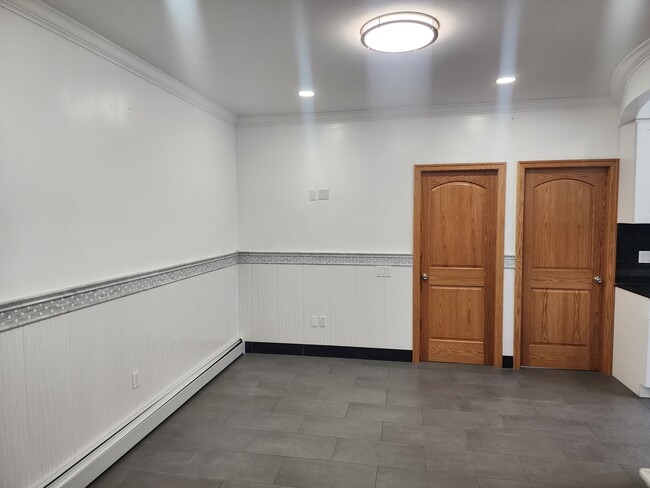
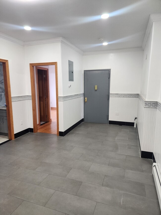
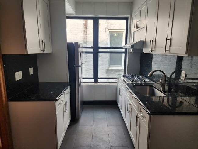
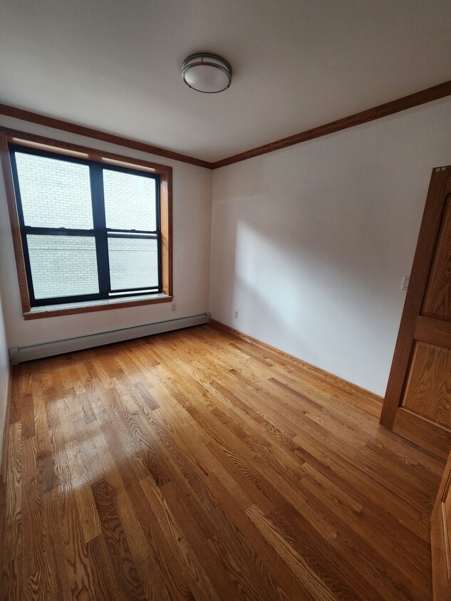
13259 Maple Ave Unit Maple Ave Flushing Queens Photos
-
2nd bedroom
-
Living room
-
Entrance to the 2R Apt
-
Living room
-
Kitchen
-
New appliance
-
Full bath
-
Master's bedroom with the 2nd full bathroom
-
What Are Walk Score®, Transit Score®, and Bike Score® Ratings?
Walk Score® measures the walkability of any address. Transit Score® measures access to public transit. Bike Score® measures the bikeability of any address.
What is a Sound Score Rating?
A Sound Score Rating aggregates noise caused by vehicle traffic, airplane traffic and local sources
13259 Maple Ave
Flushing, NY 11355