-
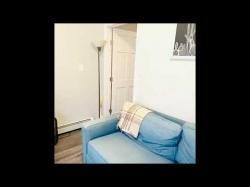
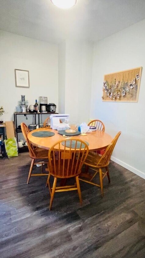
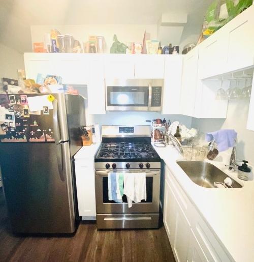
1 bedroom in East Boston MA
-
-
$1,800
Total Monthly Price
129 Eutaw St
Boston, MA 02128
2 Weeks Ago
|
Edit
Favorites
129 Eutaw St

Favorites
Check Back Soon for Upcoming Availability
| Beds | Baths | Average SF |
|---|---|---|
| 1 Bedroom 1 Bedroom 1 Br | 1 Bath 1 Bath 1 Ba | — |
About This Property
VIRTUAL TOUR:https://www.youtube.com/watch?v=t17 a9sSRcRk-------TRANSPORTATIONBus: Shuttle Airport Subway Station (0.50 mi)Bus: 116 Meridian St @ White St (0.24 mi)Subway: Blue Line Airport (0.46 mi)Bus: SL3 Airport (0.46 mi)Bus: 120 Bennington St @ Putnam St (0.23 mi)Bus: 117 Meridian St @ White St (0.24 mi)Bus: 121 Lexington St @ Brooks St (0.10 mi)Bus: 112 Chelsea St @ Eagle Sq (0.47 mi) Terms: Fee Payor: Tenant, LID: 40559383.
129 Eutaw St is a condo located in Suffolk County and the 02128 ZIP Code. This area is served by the Boston Public Schools attendance zone.
129 Eutaw St,
Boston,
MA
02128
Eagle Hill is one of Boston’s most historic neighborhoods, with many well-preserved Victorian homes scattered around the community. Bordered on two sides by water, numerous marinas are close at hand in this triangular neighborhood, making it a popular area among boaters and fishermen.
The local dining scene offers plenty to please every taste, representing every corner of Boston’s diverse cultural landscape. With Logan International Airport positioned just a few streets away, Eagle Hill is an excellent location for folks who work at the airport or for the airlines.
Learn more about living in Eagle HillBelow are rent ranges for similar nearby apartments
| Beds | Average Size | Lowest | Typical | Premium |
|---|---|---|---|---|
| Studio Studio Studio | 450 Sq Ft | $1,900 | $2,048 | $2,295 |
| 1 Bed 1 Bed 1 Bed | 1995 Sq Ft | $1,175 | $2,221 | $3,300 |
| 2 Beds 2 Beds 2 Beds | 1837 Sq Ft | $2,025 | $2,939 | $5,250 |
| 3 Beds 3 Beds 3 Beds | 2406 Sq Ft | $2,800 | $3,348 | $4,600 |
| 4 Beds 4 Beds 4 Beds | 4328 Sq Ft | $2,800 | $4,194 | $7,200 |
Education
| Colleges & Universities | Distance | ||
|---|---|---|---|
| Colleges & Universities | Distance | ||
| Drive: | 7 min | 2.7 mi | |
| Drive: | 9 min | 3.2 mi | |
| Drive: | 8 min | 3.6 mi | |
| Drive: | 9 min | 4.7 mi |
129 Eutaw St is within 7 minutes or 2.7 miles from Suffolk University. It is also near Emerson College and Tufts University, Boston.
Schools


Public Elementary & Middle School
Grades PK-8
Nearby
Public Elementary School
Grades PK-5
Nearby
Public Middle & High School
Grades 6-12
Nearby
Private Elementary & Middle School
Grades PK-8
Nearby
Private High School
Grades 9-12
Nearby
School data provided by
 The GreatSchools Rating helps parents compare schools within a state based on a variety of school quality indicators and provides a helpful picture of how effectively each school serves all of its students. Ratings are on a scale of 1 (below average) to 10 (above average) and can include test scores, college readiness, academic progress, advanced courses, equity, discipline and attendance data. We also advise parents to visit schools, consider other information on school performance and programs, and consider family needs as part of the school selection process.
View GreatSchools Rating Methodology
Data provided by GreatSchools.org © 2026. All rights reserved.
View GreatSchools Rating Methodology
Data provided by GreatSchools.org © 2026. All rights reserved.
Transportation options available in Boston include Maverick Station, located 0.9 mile from 129 Eutaw St. 129 Eutaw St is near General Edward Lawrence Logan International, located 2.3 miles or 6 minutes away.
| Transit / Subway | Distance | ||
|---|---|---|---|
| Transit / Subway | Distance | ||
|
|
Walk: | 18 min | 0.9 mi |
|
|
Drive: | 3 min | 1.2 mi |
|
|
Drive: | 5 min | 1.9 mi |
|
|
Drive: | 5 min | 2.2 mi |
|
|
Drive: | 6 min | 2.6 mi |
| Commuter Rail | Distance | ||
|---|---|---|---|
| Commuter Rail | Distance | ||
| Drive: | 5 min | 1.7 mi | |
|
|
Drive: | 6 min | 2.4 mi |
|
|
Drive: | 7 min | 3.2 mi |
|
|
Drive: | 12 min | 4.4 mi |
|
|
Drive: | 10 min | 4.7 mi |
| Airports | Distance | ||
|---|---|---|---|
| Airports | Distance | ||
|
General Edward Lawrence Logan International
|
Drive: | 6 min | 2.3 mi |
Walkability Near 129 Eutaw St Boston, MA 02128
Getting Around
 What do Walkability, Transit, Drivability, and Bikeability mean?
Walkability measures the walking distance to day-to-day needs.
Transit measures access to public transportation.
Drivability measures congestion, parking availability, and access to major roads.
Bikeability measures the suitability for cycling.
How It Works
What do Walkability, Transit, Drivability, and Bikeability mean?
Walkability measures the walking distance to day-to-day needs.
Transit measures access to public transportation.
Drivability measures congestion, parking availability, and access to major roads.
Bikeability measures the suitability for cycling.
How It Works
Exceptionally Walkable
Walkability
100
/ 100
Exceptional Public Transit
Transit
90
/ 100
Fairly Drivable
Drivability
50
/ 100
Moderately Bikeable
Bikeability
70
/ 100
Scores provided by
Busy
Soundscore™
61
/ 100
Traffic
ActiveAirport
BusyBusinesses
BusyScores provided by
HowLoud What is a Sound Score Rating? A Sound Score Rating aggregates noise caused by vehicle traffic, airplane traffic and local sources. How It WorksTime and distance from 129 Eutaw St.
| Shopping Centers | Distance | ||
|---|---|---|---|
| Shopping Centers | Distance | ||
| Walk: | 10 min | 0.6 mi | |
| Drive: | 4 min | 1.6 mi | |
| Drive: | 6 min | 2.3 mi |
129 Eutaw St has 3 shopping centers within 2.3 miles, which is about a 6-minute drive. The miles and minutes will be for the farthest away property.
| Parks and Recreation | Distance | ||
|---|---|---|---|
| Parks and Recreation | Distance | ||
|
Boston National Historical Park
|
Drive: | 7 min | 2.6 mi |
|
New England Aquarium
|
Drive: | 7 min | 2.8 mi |
|
Boston African American National Historic Site
|
Drive: | 8 min | 2.9 mi |
|
Boston Harbor Islands National Recreation Area
|
Drive: | 7 min | 2.9 mi |
|
Museum of Science
|
Drive: | 8 min | 3.0 mi |
129 Eutaw St has 5 parks within 3.0 miles, including New England Aquarium, Boston National Historical Park, and Boston African American National Historic Site.
| Hospitals | Distance | ||
|---|---|---|---|
| Hospitals | Distance | ||
| Drive: | 7 min | 2.7 mi | |
| Drive: | 7 min | 2.7 mi | |
| Drive: | 9 min | 3.7 mi |
129 Eutaw St has 3 hospitals within 3.7 miles, the nearest is Shriners Hospital for Children - Boston which is 2.7 miles away and a 7 minute drive.
| Military Bases | Distance | ||
|---|---|---|---|
| Military Bases | Distance | ||
| Drive: | 27 min | 14.8 mi | |
| Drive: | 28 min | 15.6 mi |
129 Eutaw St is 14.8 miles from Fort Pickering, and is convenient to other military bases, including Fort Miller.
You May Also Like
Similar Rentals Nearby


What Are Walk Score®, Transit Score®, and Bike Score® Ratings?
Walk Score® measures the walkability of any address. Transit Score® measures access to public transit. Bike Score® measures the bikeability of any address.
What is a Sound Score Rating?
A Sound Score Rating aggregates noise caused by vehicle traffic, airplane traffic and local sources.

129 Eutaw St
Boston, MA 02128