
$4,300
/ Month
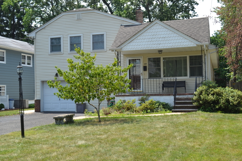
129 Beech St
Cranford, NJ 07016
2 Weeks Ago
|
Edit
Favorites
129 Beech St

Favorites
Check Back Soon for Upcoming Availability
| Beds | Baths | Average SF |
|---|---|---|
| 4 Bedrooms 4 Bedrooms 4 Br | 3 Baths 3 Baths 3 Ba | — |
Fees and Policies
The fees below are based on community-supplied data and may exclude additional fees and utilities.
- Parking
-
Garage--
About This Property
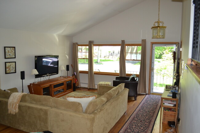
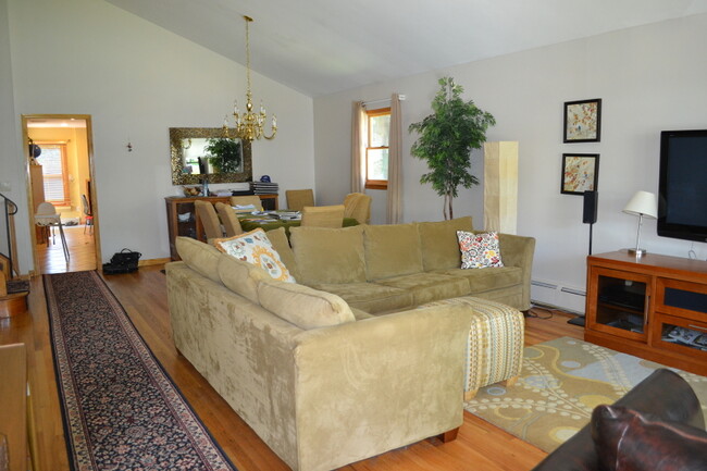
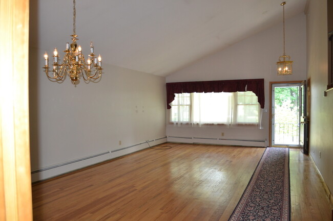
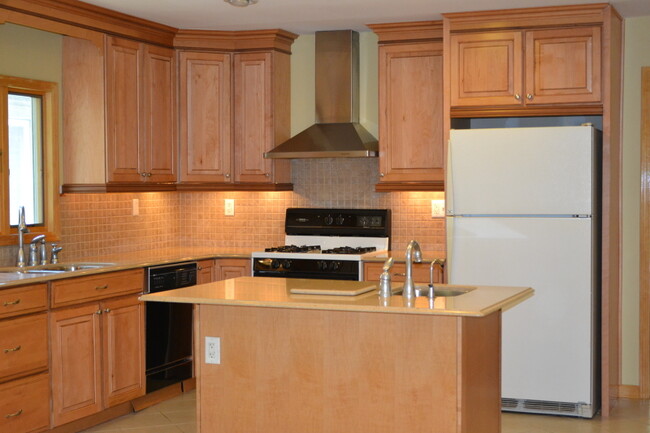
Not an ordinary split level home - you have to seriously see this one - living room/dining rm combo with high ceilings, updated gourmet kitchen plus additional prep sink in center island complete
129 Beech St is a house located in Union County and the 07016 ZIP Code. This area is served by the Cranford Public attendance zone.
House Features
- Dishwasher
- Carpet
- Deck
Location
Get Directions
Cranford is a peaceful suburb situated in the heart of Union County. Lush with township and county parks as well as the Rahway River Parkway, Cranford offers ample opportunities to engage in outdoor recreation and connect with nature. Cranford is also home to the last working farm in Union County, Dreyer Farms, which provides fresh produce in addition to hosting a variety of special events.
Cranford’s vibrant downtown area contains a slew of restaurants, specialty shops, cafes, and art galleries in colorful buildings, serving as a gathering place for the close-knit community. Commuting and traveling from Cranford is easy with access to the NJ Transit bus, Raritan Valley train line, and the Garden State Parkway. New York City and its many dynamic amenities are less than an hour’s drive or train ride away from Cranford.
Learn more about living in Cranford
Amenities
- Dishwasher
- Carpet
- Deck
Education
| Colleges & Universities | Distance | ||
|---|---|---|---|
| Colleges & Universities | Distance | ||
| Walk: | 16 min | 0.8 mi | |
| Drive: | 14 min | 6.0 mi | |
| Drive: | 18 min | 7.0 mi | |
| Drive: | 15 min | 7.3 mi |
129 Beech St is within 16 minutes or 0.8 mile from Union County College, Cranford. It is also near Kean University and Union County Coll., Elizabeth.
Schools


Public Elementary & Middle School
Grades PK-8
357 Students
Nearby
Public Elementary School
Grades K-5
355 Students
Nearby
Public High School
Grades 9-12
1,095 Students
Attendance Zone
Private Elementary, Middle & High School
Grades PK-12
Nearby
Private Elementary & Middle School
Grades PK-8
234 Students
Nearby
School data provided by
 The GreatSchools Rating helps parents compare schools within a state based on a variety of school quality indicators and provides a helpful picture of how effectively each school serves all of its students. Ratings are on a scale of 1 (below average) to 10 (above average) and can include test scores, college readiness, academic progress, advanced courses, equity, discipline and attendance data. We also advise parents to visit schools, consider other information on school performance and programs, and consider family needs as part of the school selection process.
View GreatSchools Rating Methodology
Data provided by GreatSchools.org © 2025. All rights reserved.
View GreatSchools Rating Methodology
Data provided by GreatSchools.org © 2025. All rights reserved.
Transportation options available in Cranford include Warren Street, located 11.1 miles from 129 Beech St. 129 Beech St is near Newark Liberty International, located 12.8 miles or 19 minutes away, and LaGuardia, located 32.1 miles or 54 minutes away.
| Transit / Subway | Distance | ||
|---|---|---|---|
| Transit / Subway | Distance | ||
|
|
Drive: | 19 min | 11.1 mi |
|
|
Drive: | 19 min | 11.2 mi |
|
|
Drive: | 19 min | 11.3 mi |
|
|
Drive: | 19 min | 11.6 mi |
|
|
Drive: | 19 min | 11.9 mi |
| Commuter Rail | Distance | ||
|---|---|---|---|
| Commuter Rail | Distance | ||
|
|
Walk: | 20 min | 1.1 mi |
|
|
Walk: | 20 min | 1.1 mi |
|
|
Drive: | 6 min | 2.0 mi |
|
|
Drive: | 10 min | 3.8 mi |
|
|
Drive: | 12 min | 4.2 mi |
| Airports | Distance | ||
|---|---|---|---|
| Airports | Distance | ||
|
Newark Liberty International
|
Drive: | 19 min | 12.8 mi |
|
LaGuardia
|
Drive: | 54 min | 32.1 mi |
Time and distance from 129 Beech St.
| Shopping Centers | Distance | ||
|---|---|---|---|
| Shopping Centers | Distance | ||
| Walk: | 17 min | 0.9 mi | |
| Drive: | 4 min | 1.1 mi | |
| Drive: | 4 min | 1.2 mi |
129 Beech St has 3 shopping centers within 1.2 miles, which is about a 4-minute drive. The miles and minutes will be for the farthest away property.
| Parks and Recreation | Distance | ||
|---|---|---|---|
| Parks and Recreation | Distance | ||
|
William Miller Sperry Observatory
|
Walk: | 13 min | 0.7 mi |
|
Trailside Museum Watchung Reservation
|
Drive: | 11 min | 4.0 mi |
|
Cora Hartshorn Arboretum
|
Drive: | 16 min | 6.2 mi |
|
Reeves-Reed Arboretum
|
Drive: | 16 min | 6.7 mi |
|
Hawk Rise Sanctuary
|
Drive: | 17 min | 7.0 mi |
129 Beech St has 5 parks within 7.0 miles, including William Miller Sperry Observatory, Trailside Museum Watchung Reservation, and Cora Hartshorn Arboretum.
| Hospitals | Distance | ||
|---|---|---|---|
| Hospitals | Distance | ||
| Drive: | 12 min | 5.4 mi | |
| Drive: | 14 min | 6.2 mi | |
| Drive: | 16 min | 6.4 mi |
129 Beech St has 3 hospitals within 6.4 miles, the nearest is Robert Wood Johnson University Hospital at Rahway which is 5.4 miles away and a 12 minute drive.
| Military Bases | Distance | ||
|---|---|---|---|
| Military Bases | Distance | ||
| Drive: | 14 min | 3.6 mi | |
| Drive: | 15 min | 6.2 mi | |
| Drive: | 25 min | 16.6 mi |
129 Beech St has 3 military bases within 16.6 miles, the nearest is Tamdques Reservation which is 3.6 miles away and a 14 minute drive.
You May Also Like
How do I access Social Services in New Jersey?
Statewide service is free, confidential, multilingual and always open. Three easy ways to reach Social Services in NJ: Dial 2-1-1; text your zip code to 898-211; or chat at https://www.nj211.org
Similar Rentals Nearby


What Are Walk Score®, Transit Score®, and Bike Score® Ratings?
Walk Score® measures the walkability of any address. Transit Score® measures access to public transit. Bike Score® measures the bikeability of any address.
What is a Sound Score Rating?
A Sound Score Rating aggregates noise caused by vehicle traffic, airplane traffic and local sources

129 Beech St
Cranford, NJ 07016