
$2,500 / Month
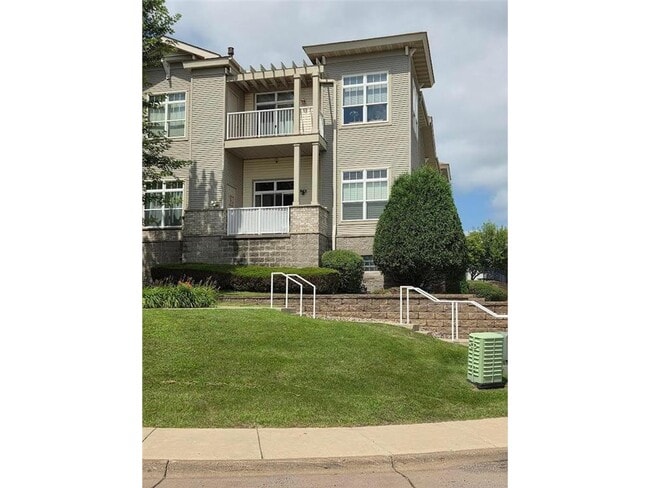
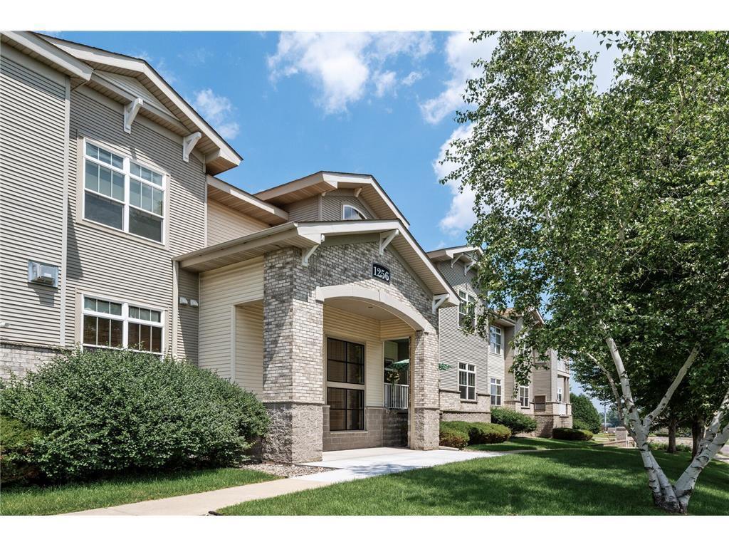
1256 County Rd D E Unit 103
Maplewood, MN 55109
Today
Favorites
651-295-2553
-
Bedrooms
3
-
Bathrooms
2
-
Square Feet
1,720 sq ft
-
Available
Available Now
Highlights
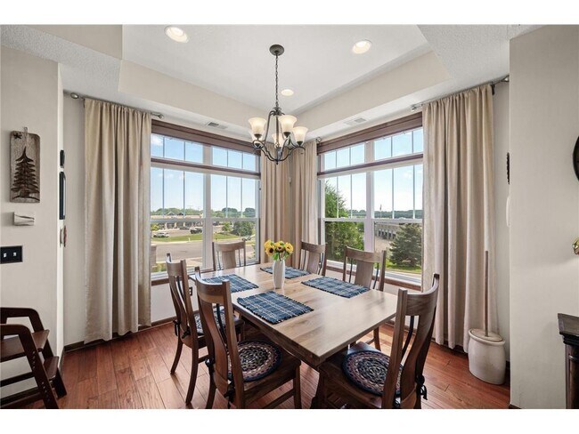
- City View
- Stainless Steel Appliances
- The kitchen features windows
- Walk-In Closet
- Entrance Foyer
- Guest Parking
1256 County Rd D E Unit 103

Favorites
About This Home
$2,500 deposit,
Available Now
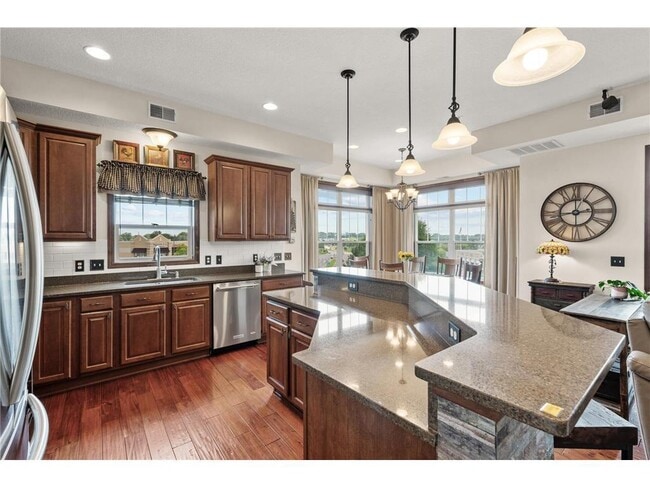
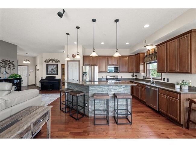
Luxurious one-level, gourmet kitchen with Stainless appliances. 10 foot ceilings and large windows with custom blinds and fabulous views. Primary bedroom suite with walk in closet & private bath with separate shower, soaking tub and double sinks. Gleaming hardwood floors in the living area, Nice cozy fireplace and sliding doors to covered deck. Heated and air conditioned underground parking for 2 cars, plus a storage locker. Quiet building with a security system. Close to freeways, walking paths and shopping. A must see!
1256 County Rd D E is an apartment community located in Ramsey County and the 55109 ZIP Code.
* Price shown is base rent and may not include non-optional fees and utilities.
Price, availability, fees, and any applicable rent special are subject to change without notice.
* Square footage definitions vary. Displayed square footage is approximate.
Home Details
Home Type
Condominium
Year Built
Built in 2007
Basement
Basement Fills Entire Space Under The House
Shared Basement
Bedrooms and Bathrooms
Walk-In Closet
2 Full Bathrooms
3 Bedrooms
Interior Spaces
Living Room with Fireplace
Entrance Foyer
1-Story Property
Electric Fireplace
1,720 Sq Ft Home
Utility Room Floor Drain
Kitchen
Stainless Steel Appliances
The kitchen features windows
Range
Microwave
Dishwasher
Disposal
Laundry
Dryer
Washer
Listing and Financial Details
Property Available on 8/16/25
Tenant pays for cable TV, gas, heat
The owner pays for trash collection, water
Lot Details
Zero Lot Line
Parking
Guest Parking
2 Car Garage
Heated Garage
Garage Door Opener
Utilities
Forced Air Heating and Cooling System
Cable TV Available
100 Amp Service
Views
City Views
Community Details
Overview
No Home Owners Association
Low-Rise Condominium
Cic 668 Heritage Square 4Th Add Subdivision
Association fees include maintenance structure, hazard insurance, lawn care, professional mgmt, trash, security, sewer, snow removal
Fees and Policies
The fees below are based on community-supplied data and may exclude additional fees and utilities.
- Parking
-
Garage--Assigned Parking
-
Other--Assigned Parking
Contact
- Listed by James M. Prescott | JPS Pro Realty
- Phone Number
- Contact
-
Source
 NorthstarMLS®
Copyright © 2025 Regional Multiple Listing Service of Minnesota [NorthStarMLS]. All rights reserved. All information provided by the listing agent/broker is deemed reliable but is not guaranteed and should be independently verified.
Location
Get Directions
Amenities
- Washer/Dryer
- Washer/Dryer Hookup
- Air Conditioning
- Heating
- Ceiling Fans
- Security System
- Fireplace
- Sprinkler System
- Wheelchair Accessible (Rooms)
- Dishwasher
- Disposal
- Island Kitchen
- Kitchen
- Microwave
- Range
- Refrigerator
- Hardwood Floors
- Dining Room
- Basement
- Vaulted Ceiling
- Walk-In Closets
- Elevator
- Deck
Thanks to some odd geography, Maplewood has something of a split personality. This first-ring St. Paul suburb can be described as being shaped like a frying pan. The main business and residential area lies primarily to the north and east of St. Paul, while the chief amenities, such as the community center and an indoor mall, lie in the "pan." South Maplewood, or the "pan handle," runs south along Interstate 494 and has fewer business amenities. Residents of this area tend to shop in bordering Woodbury, since it takes a good half hour to get from the southern tip of Maplewood to the main northern business district.
Meanwhile, Oakdale lies between the two sections, just east of Maplewood's pan handle and north of Woodbury. This young suburb is a quiet bedroom community with a scattering of business districts. Cornfields make up its eastern portion, giving the area a distinctly rural vibe, even though it's just 10 minutes outside of downtown St. Paul.
Learn more about living in Maplewood-Oakdale
Education
| Colleges & Universities | Distance | ||
|---|---|---|---|
| Colleges & Universities | Distance | ||
| Drive: | 6 min | 4.1 mi | |
| Drive: | 11 min | 5.7 mi | |
| Drive: | 13 min | 8.2 mi | |
| Drive: | 14 min | 8.7 mi |
1256 County Rd D E Unit 103 is within 6 minutes or 4.1 miles from Century College. It is also near Metropolitan State University and Northwestern College.
Transportation options available in Maplewood include Robert St Station, located 7.7 miles from 1256 County Rd D E Unit 103. 1256 County Rd D E Unit 103 is near Minneapolis-St Paul International/Wold-Chamberlain, located 17.4 miles or 27 minutes away.
| Transit / Subway | Distance | ||
|---|---|---|---|
| Transit / Subway | Distance | ||
| Drive: | 11 min | 7.7 mi | |
| Drive: | 12 min | 7.8 mi | |
| Drive: | 11 min | 7.9 mi | |
| Drive: | 12 min | 7.9 mi | |
| Drive: | 12 min | 8.0 mi |
| Commuter Rail | Distance | ||
|---|---|---|---|
| Commuter Rail | Distance | ||
|
|
Drive: | 12 min | 8.0 mi |
|
|
Drive: | 19 min | 13.6 mi |
|
|
Drive: | 23 min | 14.6 mi |
|
|
Drive: | 29 min | 21.7 mi |
|
|
Drive: | 30 min | 23.4 mi |
| Airports | Distance | ||
|---|---|---|---|
| Airports | Distance | ||
|
Minneapolis-St Paul International/Wold-Chamberlain
|
Drive: | 27 min | 17.4 mi |
Time and distance from 1256 County Rd D E Unit 103.
| Shopping Centers | Distance | ||
|---|---|---|---|
| Shopping Centers | Distance | ||
| Drive: | 4 min | 1.5 mi | |
| Drive: | 5 min | 1.8 mi | |
| Drive: | 5 min | 1.8 mi |
1256 County Rd D E Unit 103 has 3 shopping centers within 1.8 miles, which is about a 5-minute drive. The miles and minutes will be for the farthest away property.
| Parks and Recreation | Distance | ||
|---|---|---|---|
| Parks and Recreation | Distance | ||
|
Phelan Regional Park
|
Drive: | 8 min | 3.8 mi |
|
Keller Regional Park
|
Drive: | 7 min | 3.8 mi |
|
Phalen Park
|
Drive: | 8 min | 3.9 mi |
|
Arlington/Arkwright Park
|
Drive: | 8 min | 4.4 mi |
|
Harriet Alexander Nature Center
|
Drive: | 9 min | 5.6 mi |
1256 County Rd D E Unit 103 has 5 parks within 5.6 miles, including Keller Regional Park, Phelan Regional Park, and Phalen Park.
| Hospitals | Distance | ||
|---|---|---|---|
| Hospitals | Distance | ||
| Drive: | 3 min | 1.3 mi | |
| Drive: | 11 min | 7.5 mi | |
| Drive: | 11 min | 7.5 mi |
1256 County Rd D E Unit 103 has 3 hospitals within 7.5 miles, the nearest is Healtheast St. John's Hospital which is 1.3 miles away and a 3 minute drive.
| Military Bases | Distance | ||
|---|---|---|---|
| Military Bases | Distance | ||
| Drive: | 26 min | 16.1 mi |
1256 County Rd D E Unit 103 is 16.1 miles and a 26 minute drive from Fort Snelling Military Reservation.
You May Also Like
Similar Rentals Nearby


What Are Walk Score®, Transit Score®, and Bike Score® Ratings?
Walk Score® measures the walkability of any address. Transit Score® measures access to public transit. Bike Score® measures the bikeability of any address.
What is a Sound Score Rating?
A Sound Score Rating aggregates noise caused by vehicle traffic, airplane traffic and local sources
1256 County Rd D E
Maplewood, MN 55109