
$1,945
/ Month
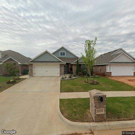
12332 SW 31st St
Yukon, OK 73099
Favorites
12332 SW 31st St

Favorites
Check Back Soon for Upcoming Availability
| Beds | Baths | Average SF |
|---|---|---|
| 3 Bedrooms 3 Bedrooms 3 Br | 3 Baths 3 Baths 3 Ba | 1,750 SF |
Fees and Policies
The fees listed below are community-provided and may exclude utilities or add-ons. All payments are made directly to the property and are non-refundable unless otherwise specified.
- Dogs Allowed
-
Fees not specified
- Cats Allowed
-
Fees not specified
About This Property
This large, and open floor plan features 1,905 Sqft of total living space, which includes 1,750 Sqft of indoor living & 155 Sqft of outdoor living space. Home offers 3 beds, 2 full baths, wood blinds throughout, & a 2-car garage with storm shelter installed. The spacious living room has a stack stone surround corner fireplace & great large windows perfect for entertaining guests and family. Kitchen is spacious with a large pantry, cabinets to the ceiling, 3 CM countertops, stainless-steel appliances & decorative backsplash. Primary bedroom provides a sloped ceiling detail and has an attached private bathroom with a Jetted tub, spacious walk-in shower & a huge closet with access to the utility room. Outdoor living has a fireplace, a gas line hook-up, a cable outlet, & full fencing. Pets case by case. ***Home is marketed for both lease or sale???*** Tenant is responsible for refrigerator, washer, and dryer. Gas range, microwave, and dishwasher are built in.
12332 Sw 31st St is a house located in Canadian County and the 73099 ZIP Code. This area is served by the Mustang School District attendance zone.
12332 SW 31st St,
Yukon,
OK
73099
As its name suggests, Southwest Oklahoma City is a neighborhood west of Oklahoma City that stretches from the Canadian River to Highway 66. Most of this community includes open spaces and farmland, but the closer to the city you travel, the more populated the area becomes. Residential neighborhoods and modern shops and restaurants can be found in the eastern sections of town. Renters can find several options for affordable apartments, single-family homes, and townhomes here too. Major roads like Interstate 40 allow for easy travel in and out of the neighborhood, and the Will Rogers World Airport, located just outside of the southeastern corner of the neighborhood, makes farther travel accessible.
Learn more about living in Southwest Oklahoma CityBelow are rent ranges for similar nearby apartments
| Beds | Average Size | Lowest | Typical | Premium |
|---|---|---|---|---|
| Studio Studio Studio | 1381 Sq Ft | $894 | $1,769 | $4,000 |
| 1 Bed 1 Bed 1 Bed | 748-749 Sq Ft | $865 | $1,142 | $1,700 |
| 2 Beds 2 Beds 2 Beds | 1116 Sq Ft | $1,025 | $1,322 | $2,350 |
| 3 Beds 3 Beds 3 Beds | 1392 Sq Ft | $1,196 | $1,583 | $2,400 |
| 4 Beds 4 Beds 4 Beds | 1766 Sq Ft | $1,470 | $1,945 | $3,200 |
Education
| Colleges & Universities | Distance | ||
|---|---|---|---|
| Colleges & Universities | Distance | ||
| Drive: | 17 min | 11.7 mi | |
| Drive: | 16 min | 11.7 mi | |
| Drive: | 20 min | 13.4 mi | |
| Drive: | 24 min | 15.5 mi |
12332 SW 31st St is within 17 minutes or 11.7 miles from OSU-Oklahoma City. It is also near Southern Nazarene University and Okla. City Comm. Coll..
Schools


Public Elementary School
Grades K-5
804 Students
Nearby
Public Elementary School
Grades PK-5
693 Students
Nearby
Public Elementary School
Grades PK-5
516 Students
Attendance Zone
Public Middle School
Grades 6-8
679 Students
Attendance Zone
Public High School
Grades 9-12
3,829 Students
Attendance Zone
Private Elementary, Middle & High School
Grades PK-12
Nearby
School data provided by
 The GreatSchools Rating helps parents compare schools within a state based on a variety of school quality indicators and provides a helpful picture of how effectively each school serves all of its students. Ratings are on a scale of 1 (below average) to 10 (above average) and can include test scores, college readiness, academic progress, advanced courses, equity, discipline and attendance data. We also advise parents to visit schools, consider other information on school performance and programs, and consider family needs as part of the school selection process.
View GreatSchools Rating Methodology
Data provided by GreatSchools.org © 2026. All rights reserved.
View GreatSchools Rating Methodology
Data provided by GreatSchools.org © 2026. All rights reserved.
Walkability Near 12332 SW 31st St Yukon, OK 73099
Getting Around
 What do Walkability, Transit, Drivability, and Bikeability mean?
Walkability measures the walking distance to day-to-day needs.
Transit measures access to public transportation.
Drivability measures congestion, parking availability, and access to major roads.
Bikeability measures the suitability for cycling.
How It Works
What do Walkability, Transit, Drivability, and Bikeability mean?
Walkability measures the walking distance to day-to-day needs.
Transit measures access to public transportation.
Drivability measures congestion, parking availability, and access to major roads.
Bikeability measures the suitability for cycling.
How It Works
Somewhat Walkable
Walkability
20
/ 100
Exceptionally Drivable
Drivability
100
/ 100
Fairly Bikeable
Bikeability
40
/ 100
Scores provided by
-
Soundscore™
-
/ 100
Traffic
-Airport
-Businesses
-Scores provided by
HowLoud What is a Sound Score Rating? A Sound Score Rating aggregates noise caused by vehicle traffic, airplane traffic and local sources. How It WorksYou May Also Like
Similar Rentals Nearby
-
-
1 / 26

-
-
-

-

-

-

-

-


What Are Walk Score®, Transit Score®, and Bike Score® Ratings?
Walk Score® measures the walkability of any address. Transit Score® measures access to public transit. Bike Score® measures the bikeability of any address.
What is a Sound Score Rating?
A Sound Score Rating aggregates noise caused by vehicle traffic, airplane traffic and local sources.
12332 SW 31st St
Yukon, OK 73099