
$2,100
/ Month
1222 W Silver St
Philadelphia, PA 19133
Today
|
Edit
Favorites
267-508-7781
-
Bedrooms
3
-
Bathrooms
3
-
Square Feet
--
-
Available
Available Now
1222 W Silver St

Favorites
About This Home
Available Now
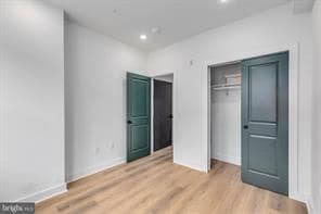
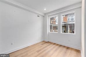
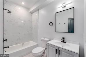
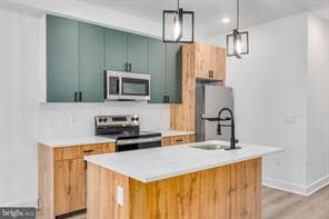
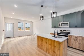
A 1 MONTH DEPOSIT TAKES THE PROPERTY OFF THE MARKET (due within 3 business days of application approval) THE REMAINING 2 MONTHS ARE NOT DUE UNTIL MOVE IN. Welcome home to your newly constructed unit! Featuring a contemporary design with a thoughtful layout and high-end finishes throughout. The kitchen is appointed with brand new stainless steel appliances, and quartz countertops, ideal for both cooking and entertaining. An open-concept floor plan provides abundant natural light and a seamless flow between living and dining areas. Residents in unit 1 will enjoy access to your own PRIVATE OUTDOOR SPACE, perfect for outdoor relaxation and entertaining. Additional highlights include energy-efficient systems, in unit washer/ dryer, modern fixtures, and ample storage. Schedule your tour today! Tenants are responsible for the following utilities: Water $50/mo flat fee (subject to change) Electric (based on usage) No GAS Internet Text the listing agent for a video tour!
1222 W Silver St is a townhome located in Philadelphia County and the 19133 ZIP Code. This area is served by the Mastery Cs-Clymer Elementary attendance zone.
* Price shown is base rent. Excludes user-selected optional fees and variable or usage-based fees and required charges due at or prior to move-in or at move-out. Price, availability, fees, and any applicable rent special are subject to change without notice.
* Square footage definitions vary. Displayed square footage is approximate.
Townhome Features
Washer/Dryer
Dishwasher
Microwave
Refrigerator
- Washer/Dryer
- Dishwasher
- Microwave
- Refrigerator
Contact
- Listed by Keller Williams Main Line
- Phone Number
- Contact
Location
Get Directions
Not to be confused with Northeast Philadelphia, North Philadelphia East encompasses the smaller subsets of Ludlow, Yorktown, West Kensington, Poplar, and Callowhill. This composite area runs from the Vine Street Expressway, stretching north to Erie Avenue. Broad Street acts as its eastern border, and the western edge runs a jagged line separating North Philadelphia East from the nearby Kensington, Port Richmond, and Fishtown neighborhoods. With such a long stretch of city, the neighborhood offers a diverse blend of important city landmarks, such as renowned musical venues the Electric Factory and Union Transfer, and Temple University, North Philadelphia's premiere site of higher learning.
Learn more about living in North Philadelphia East
Amenities
- Washer/Dryer
- Dishwasher
- Microwave
- Refrigerator
Education
| Colleges & Universities | Distance | ||
|---|---|---|---|
| Colleges & Universities | Distance | ||
| Walk: | 17 min | 0.9 mi | |
| Drive: | 4 min | 1.6 mi | |
| Drive: | 9 min | 3.1 mi | |
| Drive: | 9 min | 3.1 mi |
1222 W Silver St is within 17 minutes or 0.9 mile from Temple Univ., Health Center. It is also near Temple University, Main Campus and C.C. of Philadelphia.
Schools


Charter Elementary School
Grades K-6
448 Students
Attendance Zone
Public Elementary & Middle School
Grades PK-8
478 Students
Nearby
Charter Middle & High School
Grades 7-12
1,160 Students
Attendance Zone
Private Elementary & Middle School
Grades 5-8
37 Students
Nearby
Private High School
Grades 9-12
Nearby
School data provided by
 The GreatSchools Rating helps parents compare schools within a state based on a variety of school quality indicators and provides a helpful picture of how effectively each school serves all of its students. Ratings are on a scale of 1 (below average) to 10 (above average) and can include test scores, college readiness, academic progress, advanced courses, equity, discipline and attendance data. We also advise parents to visit schools, consider other information on school performance and programs, and consider family needs as part of the school selection process.
View GreatSchools Rating Methodology
Data provided by GreatSchools.org © 2026. All rights reserved.
View GreatSchools Rating Methodology
Data provided by GreatSchools.org © 2026. All rights reserved.
Transportation options available in Philadelphia include Allegheny - Bsl, located 0.7 mile from 1222 W Silver St. 1222 W Silver St is near Philadelphia International, located 16.2 miles or 28 minutes away, and Trenton Mercer, located 33.0 miles or 50 minutes away.
| Transit / Subway | Distance | ||
|---|---|---|---|
| Transit / Subway | Distance | ||
| Walk: | 12 min | 0.7 mi | |
|
|
Walk: | 12 min | 0.7 mi |
|
|
Drive: | 3 min | 1.2 mi |
|
|
Drive: | 4 min | 1.5 mi |
|
|
Drive: | 4 min | 1.8 mi |
| Commuter Rail | Distance | ||
|---|---|---|---|
| Commuter Rail | Distance | ||
|
|
Walk: | 4 min | 0.2 mi |
|
|
Walk: | 6 min | 0.3 mi |
|
|
Walk: | 8 min | 0.4 mi |
|
|
Drive: | 3 min | 1.2 mi |
|
|
Drive: | 4 min | 1.4 mi |
| Airports | Distance | ||
|---|---|---|---|
| Airports | Distance | ||
|
Philadelphia International
|
Drive: | 28 min | 16.2 mi |
|
Trenton Mercer
|
Drive: | 50 min | 33.0 mi |
Time and distance from 1222 W Silver St.
| Shopping Centers | Distance | ||
|---|---|---|---|
| Shopping Centers | Distance | ||
| Walk: | 9 min | 0.5 mi | |
| Walk: | 10 min | 0.6 mi | |
| Walk: | 17 min | 0.9 mi |
1222 W Silver St has 3 shopping centers within 0.9 mile, which is about a 17-minute walk. The miles and minutes will be for the farthest away property.
| Parks and Recreation | Distance | ||
|---|---|---|---|
| Parks and Recreation | Distance | ||
|
Wagner Free Institute of Science
|
Drive: | 5 min | 1.5 mi |
|
Edgar Allan Poe Nat'l Historic Site
|
Drive: | 8 min | 2.7 mi |
|
The Academy of Natural Sciences
|
Drive: | 9 min | 3.6 mi |
|
Franklin Institute
|
Drive: | 9 min | 3.8 mi |
|
Fels Planetarium
|
Drive: | 10 min | 3.8 mi |
1222 W Silver St has 5 parks within 3.8 miles, including Wagner Free Institute of Science, Edgar Allan Poe Nat'l Historic Site, and The Academy of Natural Sciences.
| Hospitals | Distance | ||
|---|---|---|---|
| Hospitals | Distance | ||
| Walk: | 16 min | 0.9 mi | |
| Walk: | 19 min | 1.0 mi | |
| Drive: | 5 min | 1.9 mi |
1222 W Silver St has 3 hospitals within 1.9 miles, the nearest is Temple University Hospital which is 0.9 mile away and a 16 minute walk.
| Military Bases | Distance | ||
|---|---|---|---|
| Military Bases | Distance | ||
| Drive: | 18 min | 10.5 mi |
1222 W Silver St is 10.5 miles and a 18 minute drive from Philadelphia Naval Busi Center.
You May Also Like
Similar Rentals Nearby
-
-
-
-
-
-
-
3 Beds$1,699+Total Monthly PriceTotal Monthly Price NewPrices include all required monthly fees.
-
1 / 24

-
-


What Are Walk Score®, Transit Score®, and Bike Score® Ratings?
Walk Score® measures the walkability of any address. Transit Score® measures access to public transit. Bike Score® measures the bikeability of any address.
What is a Sound Score Rating?
A Sound Score Rating aggregates noise caused by vehicle traffic, airplane traffic and local sources
1222 W Silver St
Philadelphia, PA 19133