$2,288
/ Month
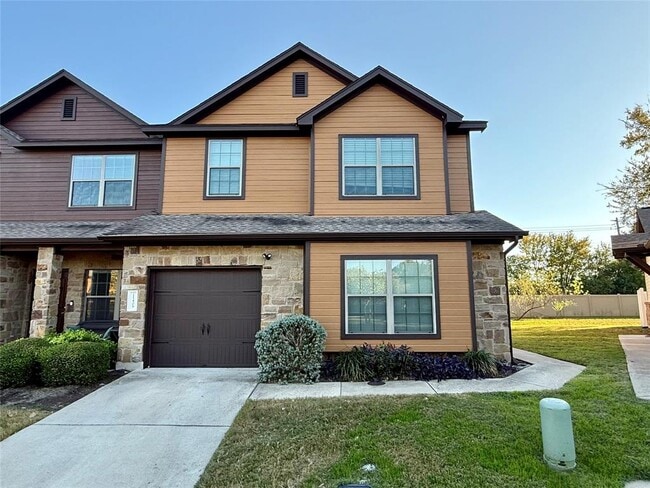
11409 Lost Maples Trail
Austin, TX 78748
Today
|
Edit
Favorites
512-565-5593
-
Bedrooms
3
-
Bathrooms
3
-
Square Feet
1,922 sq ft
-
Available
Available Now
Highlights
- Wooded Lot
- Cathedral Ceiling
- Wood Flooring
- Main Floor Primary Bedroom
- Park or Greenbelt View
- Community Pool
11409 Lost Maples Trail

Favorites
About This Home
Available Now
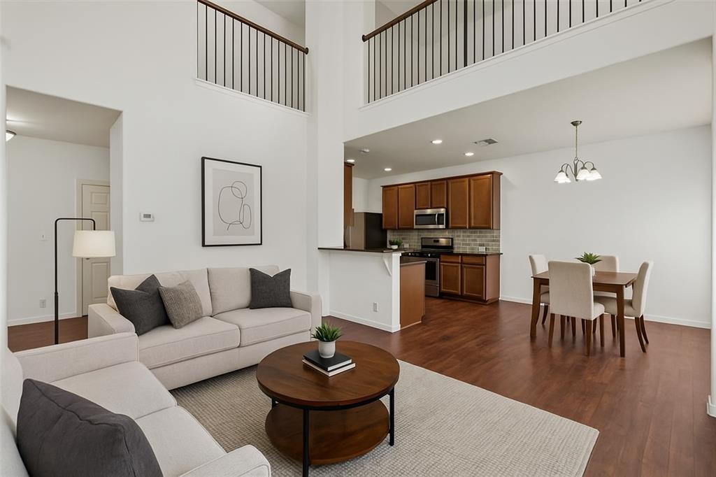
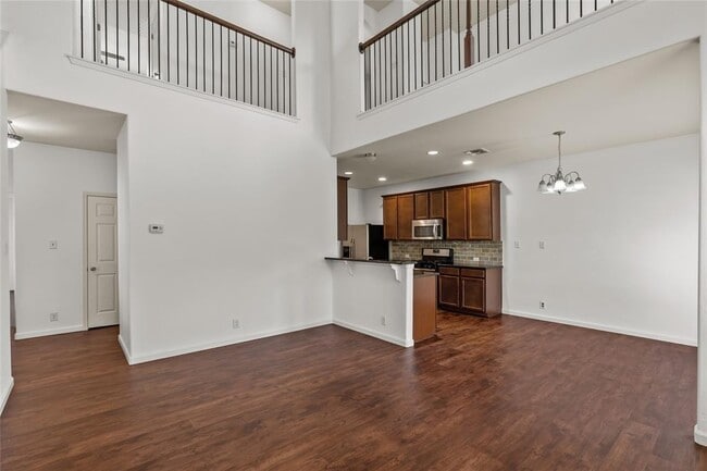
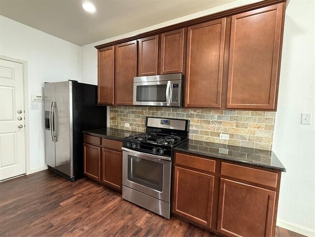
Beautiful spacious South Austin townhome with 3-bedrooms, 2.5-baths offering 1922 sqft in a highly desirable South Austin community. The primary bedroom is located on the main level with tray ceilings, an adorable bench seat, beautiful built-ins, a walk in closet and an en-suite bath. Also on the first floor is hard flooring throughout, several windows which allow for the natural light to shine through and an open-concept layout that flows from the living room to the dining area and kitchen. The kitchen is equipped with granite countertops, stainless steel appliances, and ample cabinet space. Upstairs, you’ll find 2bedrooms plus a bright loft space ,ideal for a home office, second living area or playroom. Enjoy the convenience of an attached garage plus included refrigerator, washer, and dryer for easy move-in. The community also offers a community pool. Located in a prime location, this home is just minutes from everyday essentials. Enjoy close proximity to Southpark Meadows, dozens of restaurants, coffee shops, boutiques, and big-box stores. You're also near H-E-B, local parks, and plenty of walking paths—perfect for those who love having plenty to do just moments from home. Pet-friendly! Up to 2 pets allowed—any breed, any weight. MLS ID 1262477
11409 Lost Maples Trail is a townhome located in Travis County and the 78748 ZIP Code. This area is served by the Austin Independent attendance zone.
* Price shown is base rent. Excludes user-selected optional fees and variable or usage-based fees and required charges due at or prior to move-in or at move-out. Price, availability, fees, and any applicable rent special are subject to change without notice.
* Square footage definitions vary. Displayed square footage is approximate.
Home Details
Home Type
Townhome
Year Built
Built in 2013
Bedrooms and Bathrooms
3 Bedrooms | 1 Primary Bedroom on Main
Walk-In Closet
Walk-in Shower
2.5 Bathrooms
Flooring
Wood
Carpet
Home Design
Brick Exterior Construction
Stone Siding
HardiePlank Type
Slab Foundation
Frame Construction
Interior Spaces
Cathedral Ceiling
Tray Ceiling
Wet Bar
Ceiling Fan
Bookcases
1,922 Sq Ft Home
2-Story Property
Kitchen
Free-Standing Range
Microwave
Dishwasher
Disposal
Laundry
Dryer
Washer
Listing and Financial Details
Security Deposit $2,299
12 Month Lease Term
$40 Application Fee
Assessor Parcel Number 04362321940000
Tax Block 27
Tenant pays for all utilities, cable TV, internet
Lot Details
5,140 Sq Ft Lot
Wooded Lot
West Facing Home
Parking
1 Car Attached Garage
Schools
Menchaca Elementary School
Paredes Middle School
Akins High School
Utilities
Central Heating and Cooling System
Heating System Uses Natural Gas
Views
Park or Greenbelt Views
Community Details
Amenities
Common Area
Overview
78 Units
Property has a Home Owners Association
Property managed by Property Management Ease
Ravenscroft Twnhms Amd Subdivision
Pet Policy
Dogs and Cats Allowed
Pet Deposit $350
Recreation
Community Pool
Fees and Policies
The fees below are based on community-supplied data and may exclude additional fees and utilities.
-
Dogs
-
Allowed
-
-
Cats
-
Allowed
-
Property Fee Disclaimer: Based on community-supplied data and independent market research. Subject to change without notice. May exclude fees for mandatory or optional services and usage-based utilities.
Contact
- Listed by Jessica Garcia | Ready Real Estate LLC
- Phone Number
- Contact
-
Source
 Austin Board of REALTORS®
The information included in this listing is provided exclusively for consumers’ personal, non-commercial use and may not be used for any purpose other than to identify prospective properties consumers may be interested in purchasing. The information on each listing is furnished by the owner and deemed reliable to the best of his/her knowledge, but should be verified by the purchaser. ABoR, ACTRIS and Estately assume no responsibility for typographical errors, misprints or misinformation. This property listing is offered without respect to any protected classes in accordance with the law. Copyright © 2026.
Location
Get Directions
Amenities
- Dishwasher
- Disposal
- Microwave
- Refrigerator
- Hardwood Floors
- Carpet
Slaughter Creek refers to a South Austin community surrounding the vibrant intersection of Manchaca Road and West Slaughter Lane, where suburban shopping centers abound. Outside of this intersection, Slaughter Creek is largely a residential community, offering residents a quiet hometown atmosphere within minutes of numerous desirable amenities.
Slaughter Creek renters have their choice of various apartments, townhomes, and houses available for rent. Renting in Slaughter Creek places you within close proximity of countless options for outdoor recreation, with convenience to sprawling destinations like Bauerle Ranch Park and Mary Moore Searight Metropolitan Park. Commuting and traveling from Slaughter Creek is simple with access to I-35, MoPac Expressway, and Austin-Bergstrom International Airport.
Learn more about living in Slaughter Creek
Education
| Colleges & Universities | Distance | ||
|---|---|---|---|
| Colleges & Universities | Distance | ||
| Drive: | 9 min | 5.1 mi | |
| Drive: | 11 min | 6.1 mi | |
| Drive: | 16 min | 9.0 mi | |
| Drive: | 15 min | 9.1 mi |
11409 Lost Maples Trail is within 9 minutes or 5.1 miles from Austin C.C., South Austin. It is also near USAHS and Austin C.C., Pinnacle Campus.
Schools


Public Elementary School
Grades PK-5
758 Students
Attendance Zone
Public Middle School
Grades 6-8
657 Students
Attendance Zone
Public High School
Grades 9-12
2,613 Students
Attendance Zone
Private Elementary, Middle & High School
Grades K-10
Nearby
Private Elementary School
Grades PK-6
93 Students
Nearby
Private Elementary School
Grades PK-5
296 Students
Nearby
Private Middle & High School
Grades 6-12
Nearby
School data provided by
 The GreatSchools Rating helps parents compare schools within a state based on a variety of school quality indicators and provides a helpful picture of how effectively each school serves all of its students. Ratings are on a scale of 1 (below average) to 10 (above average) and can include test scores, college readiness, academic progress, advanced courses, equity, discipline and attendance data. We also advise parents to visit schools, consider other information on school performance and programs, and consider family needs as part of the school selection process.
View GreatSchools Rating Methodology
Data provided by GreatSchools.org © 2026. All rights reserved.
View GreatSchools Rating Methodology
Data provided by GreatSchools.org © 2026. All rights reserved.
Transportation options available in Austin include Downtown Station, located 11.8 miles from 11409 Lost Maples Trail. 11409 Lost Maples Trail is near Austin-Bergstrom International, located 15.9 miles or 31 minutes away.
| Transit / Subway | Distance | ||
|---|---|---|---|
| Transit / Subway | Distance | ||
| Drive: | 18 min | 11.8 mi | |
| Drive: | 19 min | 12.5 mi |
| Commuter Rail | Distance | ||
|---|---|---|---|
| Commuter Rail | Distance | ||
|
|
Drive: | 20 min | 10.0 mi |
|
|
Drive: | 31 min | 24.6 mi |
| Airports | Distance | ||
|---|---|---|---|
| Airports | Distance | ||
|
Austin-Bergstrom International
|
Drive: | 31 min | 15.9 mi |
Time and distance from 11409 Lost Maples Trail.
| Shopping Centers | Distance | ||
|---|---|---|---|
| Shopping Centers | Distance | ||
| Walk: | 6 min | 0.3 mi | |
| Walk: | 6 min | 0.3 mi | |
| Walk: | 17 min | 0.9 mi |
11409 Lost Maples Trail has 3 shopping centers within 0.9 mile, which is about a 17-minute walk. The miles and minutes will be for the farthest away property.
| Parks and Recreation | Distance | ||
|---|---|---|---|
| Parks and Recreation | Distance | ||
|
Slaughter Creek at Bauerle Ranch
|
Walk: | 16 min | 0.9 mi |
|
Goat Cave Nature Preserve
|
Drive: | 9 min | 4.9 mi |
|
Circle C Ranch Metropolitan Park
|
Drive: | 11 min | 6.1 mi |
|
Dick Nichols Park
|
Drive: | 11 min | 6.3 mi |
|
Lady Bird Johnson Wildflower Center
|
Drive: | 12 min | 6.4 mi |
11409 Lost Maples Trail has 5 parks within 6.4 miles, including Slaughter Creek at Bauerle Ranch, Lady Bird Johnson Wildflower Center, and Goat Cave Nature Preserve.
| Hospitals | Distance | ||
|---|---|---|---|
| Hospitals | Distance | ||
| Drive: | 6 min | 3.3 mi | |
| Drive: | 10 min | 5.4 mi | |
| Drive: | 12 min | 7.0 mi |
11409 Lost Maples Trail has 3 hospitals within 7.0 miles, the nearest is Texas Star Recovery which is 3.3 miles away and a 6 minute drive.
| Military Bases | Distance | ||
|---|---|---|---|
| Military Bases | Distance | ||
| Drive: | 74 min | 59.6 mi | |
| Drive: | 103 min | 87.1 mi |
11409 Lost Maples Trail is 59.6 miles from Randolph Air Force Base, and is convenient to other military bases, including Camp Bullis Military Training Reservation.
You May Also Like
Similar Rentals Nearby


What Are Walk Score®, Transit Score®, and Bike Score® Ratings?
Walk Score® measures the walkability of any address. Transit Score® measures access to public transit. Bike Score® measures the bikeability of any address.
What is a Sound Score Rating?
A Sound Score Rating aggregates noise caused by vehicle traffic, airplane traffic and local sources

11409 Lost Maples Trail
Austin, TX 78748