
The Dutton Apartments
25800 Industrial Blvd,
Hayward, CA 94545
$2,418 - $3,128 Total Monthly Price
1-2 Beds

Experience Hayward living at 1050 Forselles Way. You'll find this community in the Harder Tennyson area of Hayward. From pricing to features, the leasing staff will assist you in finding the perfect apartment. It's time to love where you live. Stop by for a visit today.
1050 Forselles Way is an apartment community located in Alameda County and the 94544 ZIP Code. This area is served by the Hayward Unified School District attendance zone.
Recycling
Gated
Pet Play Area
Trash Pickup - Curbside
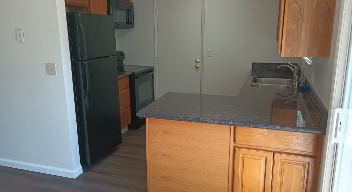
Dishwasher
Washer/Dryer Hookup
Granite Countertops
Yard
Microwave
Refrigerator
Tub/Shower
Disposal
Harder-Tennyson is a quaint, Bay Area neighborhood in the city of Hayward. The neighborhood is conveniently located along Interstate 880 and is about 10 minutes from the parks and beaches along the San Francisco Bay, such as the Eden Landing Ecological Reserve. Hayward Executive Airport is just a short drive away, as is Southland Mall and sprawling golf courses. Inside the neighborhood, ranch-style houses and green spaces like Weekes Community Center Park make up the area. While residents can easily travel to world-class restaurants in the Bay Area, the neighborhood has a variety of restaurants situated along Tennyson Road. Harder-Tennyson’s rental market is made up of a variety of low-rise apartments as well as a few condos situated along the eastern side of town.
Learn more about living in Harder-TennysonCompare neighborhood and city base rent averages by bedroom.
| Harder-Tennyson | Hayward, CA | |
|---|---|---|
| Studio | - | $2,059 |
| 1 Bedroom | $1,766 | $2,130 |
| 2 Bedrooms | $1,895 | $2,396 |
| 3 Bedrooms | $2,746 | $2,808 |
| Colleges & Universities | Distance | ||
|---|---|---|---|
| Colleges & Universities | Distance | ||
| Drive: | 7 min | 2.7 mi | |
| Drive: | 8 min | 3.2 mi | |
| Drive: | 15 min | 10.5 mi | |
| Drive: | 23 min | 15.9 mi |


Transportation options available in Hayward include South Hayward Station, located 1.5 miles from 1050 Forselles Way. 1050 Forselles Way is near Metro Oakland International, located 12.3 miles or 17 minutes away, and San Francisco International, located 22.9 miles or 30 minutes away.
| Transit / Subway | Distance | ||
|---|---|---|---|
| Transit / Subway | Distance | ||
|
|
Drive: | 4 min | 1.5 mi |
|
|
Drive: | 7 min | 3.8 mi |
|
|
Drive: | 12 min | 5.5 mi |
|
|
Drive: | 10 min | 6.3 mi |
|
|
Drive: | 13 min | 7.4 mi |
| Commuter Rail | Distance | ||
|---|---|---|---|
| Commuter Rail | Distance | ||
| Drive: | 7 min | 4.2 mi | |
|
|
Drive: | 7 min | 4.2 mi |
| Drive: | 13 min | 7.8 mi | |
| Drive: | 14 min | 8.0 mi | |
| Drive: | 27 min | 18.3 mi |
| Airports | Distance | ||
|---|---|---|---|
| Airports | Distance | ||
|
Metro Oakland International
|
Drive: | 17 min | 12.3 mi |
|
San Francisco International
|
Drive: | 30 min | 22.9 mi |
Scores provided by
Traffic
-Airport
-Businesses
-Scores provided by
HowLoud What is a Sound Score Rating? A Sound Score Rating aggregates noise caused by vehicle traffic, airplane traffic and local sources. How It WorksTime and distance from 1050 Forselles Way.
| Shopping Centers | Distance | ||
|---|---|---|---|
| Shopping Centers | Distance | ||
| Walk: | 2 min | 0.0 mi | |
| Walk: | 5 min | 0.3 mi | |
| Walk: | 10 min | 0.5 mi |
| Parks and Recreation | Distance | ||
|---|---|---|---|
| Parks and Recreation | Distance | ||
|
Garin/Dry Creek Pioneer Parks
|
Drive: | 10 min | 4.4 mi |
|
Sulphur Creek Nature Center
|
Drive: | 11 min | 4.9 mi |
|
Hayward Shoreline Interpretive Center
|
Drive: | 10 min | 5.0 mi |
|
Don Castro Regional Recreation Area
|
Drive: | 11 min | 5.8 mi |
|
Hayward Regional Shoreline
|
Drive: | 16 min | 8.0 mi |
| Hospitals | Distance | ||
|---|---|---|---|
| Hospitals | Distance | ||
| Drive: | 3 min | 1.2 mi | |
| Drive: | 11 min | 7.2 mi | |
| Drive: | 12 min | 8.7 mi |
| Military Bases | Distance | ||
|---|---|---|---|
| Military Bases | Distance | ||
| Drive: | 29 min | 19.8 mi | |
| Drive: | 30 min | 20.0 mi | |
| Drive: | 35 min | 23.9 mi |
Pets Allowed Fitness Center In Unit Washer & Dryer Stainless Steel Appliances Business Center Package Service Elevator
What Are Walk Score®, Transit Score®, and Bike Score® Ratings?
Walk Score® measures the walkability of any address. Transit Score® measures access to public transit. Bike Score® measures the bikeability of any address.
What is a Sound Score Rating?
A Sound Score Rating aggregates noise caused by vehicle traffic, airplane traffic and local sources.

1050 Glad Tidings Way
Hayward, CA 94544


