
Adara
888 N 4th St,
Phoenix, AZ 85004
$824 - $3,400
Studio - 4 Beds

Bedrooms
1 bd
Bathrooms
1 ba
Square Feet
650 sq ft
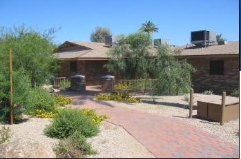
Welcome to West Rose Lane apartments, conveniently located in Uptown Phoenix! Just minutes away from shopping, entertainment, and dining at the nearby Spectrum Mall and quick access to the Black Canyon Freeway,Our charming, single-level community offers one, two and three-bedroom apartments. Come visit us today and discover the comfort and convenience of life at West Rose Lane!
Welcome to West Rose Lane apartments, conveniently located in Uptown Phoenix! Just minutes away from shopping, entertainment, and dining at the nearby Spectrum Mall and quick access to the Black Canyon Freeway,Our charming, single-level community offers one, two and three-bedroom apartments. Come visit us today and discover the comfort and convenience of life at West Rose Lane!
West Rose Lane is an apartment community located in Maricopa County and the 85013 ZIP Code. This area is served by the Washington Elementary attendance zone.
Washer/Dryer
Air Conditioning
Dishwasher
Refrigerator
North Phoenix refers to the vast swath of land that stretches from Bethany Home Road up towards the Phoenix mountains. Bounded to the east by State Route 51 and to the west by 51st Avenue, North Phoenix is home a slew of diverse communities and neighborhoods all offering a variety of rentals ranging from the upscale to the more affordable. There are numerous golf courses and of course the mountains that offer residents a number of outdoor activities to engage in. For shopping and dining, residents head to Desert Ridge Marketplace on High Street, which is filled with upscale boutiques, nightlife hotspots, restaurants, and more. Interstate 17 and Route 101 make commuting around this desirable area simple.
Learn more about living in North Phoenix| Colleges & Universities | Distance | ||
|---|---|---|---|
| Colleges & Universities | Distance | ||
| Drive: | 8 min | 3.3 mi | |
| Drive: | 9 min | 3.7 mi | |
| Drive: | 8 min | 4.0 mi | |
| Drive: | 9 min | 4.1 mi |


Transportation options available in Phoenix include 7Th Ave/Camelback, located 1.3 miles from West Rose Lane. West Rose Lane is near Phoenix Sky Harbor International, located 10.9 miles or 19 minutes away, and Phoenix-Mesa Gateway, located 37.7 miles or 51 minutes away.
| Transit / Subway | Distance | ||
|---|---|---|---|
| Transit / Subway | Distance | ||
|
|
Drive: | 2 min | 1.3 mi |
|
|
Drive: | 3 min | 1.5 mi |
|
|
Drive: | 3 min | 1.7 mi |
|
|
Drive: | 3 min | 1.9 mi |
|
|
Drive: | 4 min | 2.2 mi |
| Commuter Rail | Distance | ||
|---|---|---|---|
| Commuter Rail | Distance | ||
|
|
Drive: | 51 min | 38.8 mi |
| Airports | Distance | ||
|---|---|---|---|
| Airports | Distance | ||
|
Phoenix Sky Harbor International
|
Drive: | 19 min | 10.9 mi |
|
Phoenix-Mesa Gateway
|
Drive: | 51 min | 37.7 mi |
Time and distance from West Rose Lane.
| Shopping Centers | Distance | ||
|---|---|---|---|
| Shopping Centers | Distance | ||
| Walk: | 14 min | 0.8 mi | |
| Walk: | 15 min | 0.8 mi | |
| Walk: | 16 min | 0.8 mi |
| Parks and Recreation | Distance | ||
|---|---|---|---|
| Parks and Recreation | Distance | ||
|
Steele Indian School Park
|
Drive: | 7 min | 3.1 mi |
|
Desert Storm Park
|
Drive: | 6 min | 3.2 mi |
|
Granada Park
|
Drive: | 8 min | 3.9 mi |
|
North Mountain Park
|
Drive: | 9 min | 4.8 mi |
|
Dreamy Draw Recreation Area
|
Drive: | 13 min | 8.2 mi |
| Hospitals | Distance | ||
|---|---|---|---|
| Hospitals | Distance | ||
| Drive: | 3 min | 1.3 mi | |
| Drive: | 2 min | 1.4 mi | |
| Drive: | 7 min | 3.5 mi |
| Military Bases | Distance | ||
|---|---|---|---|
| Military Bases | Distance | ||
| Drive: | 19 min | 10.8 mi | |
| Drive: | 32 min | 16.7 mi | |
| Drive: | 104 min | 77.8 mi |
What Are Walk Score®, Transit Score®, and Bike Score® Ratings?
Walk Score® measures the walkability of any address. Transit Score® measures access to public transit. Bike Score® measures the bikeability of any address.
What is a Sound Score Rating?
A Sound Score Rating aggregates noise caused by vehicle traffic, airplane traffic and local sources
703-707 W Rose Ln
Phoenix, AZ 85013


