")
The Lofts (WV)
5000 Station St,
Morgantown, WV 26508
$587 - $2,444
2-4 Beds
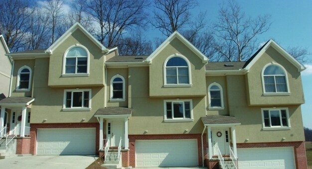
West Point in Morgantown, WV is ready for you to move in. The location in Morgantown's 26505 area is an ideal place to live. The leasing team is ready and waiting for you to come by to check us out. Come by to see the current floorplan options. Stop by West Point today.
West Point is an apartment community located in Monongalia County and the 26505 ZIP Code. This area is served by the Monongalia County Schools attendance zone.
Hardwood Floors
Walk-In Closets
Vaulted Ceiling
Heating
From white-water rafting on the Cheat River to rock climbing at Coopers Rock to shopping for antiques, there's good reason Morgantown is the most popular destination in West Virginia -- add in West Virginia University and the reasons just become more impressive. Morgantown, situated along the Monongahela River, provides stunning views of the Appalachian Mountains -- especially from vantage points like Dorsey Knob. This park covers 71 acres, and the mountain is 1,398 feet high.
Considered a top-ranking research university, WVU was established in 1867 and features several buildings listed on the National Register of Historic Places. Residents of Morgantown can visit the university's Core Arboretum, which is free and open to the public. Residents can also cheer on the West Virginia Mountaineers at various sports events. The Mountaineers compete in NCAA Division I as part of the Big 12 Conference.
Learn more about living in Morgantown| Colleges & Universities | Distance | ||
|---|---|---|---|
| Colleges & Universities | Distance | ||
| Drive: | 6 min | 2.1 mi | |
| Drive: | 7 min | 2.5 mi | |
| Drive: | 38 min | 25.5 mi | |
| Drive: | 39 min | 27.3 mi |


Transportation options available in Morgantown include Hsc, located 1.9 miles from West Point. West Point is near North Central West Virginia, located 37.2 miles or 49 minutes away.
| Transit / Subway | Distance | ||
|---|---|---|---|
| Transit / Subway | Distance | ||
| Drive: | 7 min | 1.9 mi | |
| Drive: | 8 min | 2.6 mi | |
| Drive: | 7 min | 2.6 mi | |
| Drive: | 8 min | 3.0 mi | |
| Drive: | 9 min | 4.5 mi |
| Commuter Rail | Distance | ||
|---|---|---|---|
| Commuter Rail | Distance | ||
|
|
Drive: | 48 min | 38.6 mi |
| Airports | Distance | ||
|---|---|---|---|
| Airports | Distance | ||
|
North Central West Virginia
|
Drive: | 49 min | 37.2 mi |
Time and distance from West Point.
| Shopping Centers | Distance | ||
|---|---|---|---|
| Shopping Centers | Distance | ||
| Drive: | 4 min | 1.1 mi | |
| Drive: | 4 min | 1.4 mi | |
| Drive: | 4 min | 1.5 mi |
| Parks and Recreation | Distance | ||
|---|---|---|---|
| Parks and Recreation | Distance | ||
|
Tomchin Planetarium & Observatory
|
Drive: | 8 min | 3.0 mi |
|
The Core Arboretum
|
Drive: | 10 min | 3.7 mi |
|
West Virginia Botanic Garden
|
Drive: | 20 min | 8.5 mi |
|
Friendship Hill National Historic Site
|
Drive: | 22 min | 11.5 mi |
|
Coopers Rock State Forest
|
Drive: | 28 min | 11.9 mi |
| Hospitals | Distance | ||
|---|---|---|---|
| Hospitals | Distance | ||
| Drive: | 4 min | 1.3 mi |
| Military Bases | Distance | ||
|---|---|---|---|
| Military Bases | Distance | ||
| Drive: | 100 min | 77.3 mi |
What Are Walk Score®, Transit Score®, and Bike Score® Ratings?
Walk Score® measures the walkability of any address. Transit Score® measures access to public transit. Bike Score® measures the bikeability of any address.
What is a Sound Score Rating?
A Sound Score Rating aggregates noise caused by vehicle traffic, airplane traffic and local sources

W Run Rd
Morgantown, WV 26505


